Alpine Rhine

The Alpine Rhine Valley (German: Alpenrheintal) is a glacial alpine valley, formed by the part of the Alpine Rhine (German: ![]() Alpenrhein ) between the confluence of the Anterior Rhine and Posterior Rhine at Reichenau and the Alpine Rhine's mouth at Lake Constance.
From Reichenau, the Alpine Rhine flows east, passing Chur and turning north, forms the border between the canton of St. Gallen of Switzerland on the left, west side and first Liechtenstein and then Vorarlberg, Austria on the right, east side.
The Swiss-Austrian border follows the historical bed of the Rhine, but today the river follows an artificial canal within Austria for the final 5 kilometres (3 mi).
Alpenrhein ) between the confluence of the Anterior Rhine and Posterior Rhine at Reichenau and the Alpine Rhine's mouth at Lake Constance.
From Reichenau, the Alpine Rhine flows east, passing Chur and turning north, forms the border between the canton of St. Gallen of Switzerland on the left, west side and first Liechtenstein and then Vorarlberg, Austria on the right, east side.
The Swiss-Austrian border follows the historical bed of the Rhine, but today the river follows an artificial canal within Austria for the final 5 kilometres (3 mi).

The Rhine Valley in this area extends to about 80 kilometres (50 mi). Its upper third has the character of an Alpine valley, enclosing a bottom plain of about 1 to 4 kilometres (0.6 to 2.5 mi) across. Downstream of Vaduz, the valley widens considerably, developing into a broad plain, measuring some 10 kilometres (6 mi) across at its lower end along the southern shores of Lake Constance. From the point of the Rhine's emergence from Lake Constance, it is known as High Rhine.
Tributaries of the Alpine Rhine are the Plessur, Landquart, Ill and Frutz rivers on the right side. It has no major left tributaries; streams joining it from the left are the Oldisbach at Chur, Cosenz at Untervaz, Säge at Tardisbrücke, Tamina at Bad Ragaz, Tobelbach at Burchs, Simml at Gams.
Geography

Subdivisions
The Alpine Rhine forms the eastern boundary of the Swiss cantons of Grisons and St. Gallen to Austria and Liechtenstein.
Administrative parts of the Rhine Valley are:
- left bank (Switzerland)
- Churer Rheintal (Grisons)
- St. Galler Rheintal, East Switzerland
- Rheintal (Wahlkreis), Canton St. Gallen
- right bank (Austria and Liechtenstein)
- Liechtenstein
- Rheintal (Austria), a region in Austria
The Rhine
The Alpine Rhine is formed near Tamins-Reichenau by the confluence of the Anterior Rhine and the Posterior Rhine. The river makes a distinctive turn to the north near Chur. This section is nearly 86 kilometres (53 mi) long and descends from an elevation of 599 to 396 metres (1,965 to 1,299 ft). Near Sargans a natural dam, only a few metres high, prevents it from flowing into the open Seeztal valley and then through Lake Walen and Lake Zurich into the river Aare. The Alpine Rhine begins in the centre of the Swiss canton of Grisons, and later forms the border between Switzerland to the west and Liechtenstein and later Austria to the east.
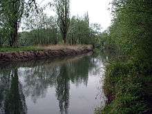
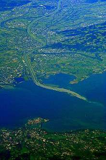
The mouth of the Rhine into Lake Constance forms an inland delta. The delta is delimited in the west by the Old Rhine and in the east by a modern canalized section. Most of the delta is a nature reserve and bird sanctuary. It includes the Austrian towns of Gaißau, Höchst and Fußach. The natural Rhine originally branched into at least two arms and formed small islands by precipitating sediments.
A regulation of the Rhine was called for, with an upper canal near Diepoldsau and a lower canal at Fußach, in order to counteract the constant flooding and strong sedimentation in the western Rhine Delta. The Dornbirner Ach had to be diverted, too, and it now flows parallel to the canalized Rhine into the lake. Its water has a darker color than the Rhine; the latter's lighter suspended load comes from higher up the mountains. It is expected that the continuous input of sediment into the lake will silt up the lake. This has already happened to the former Lake Tuggenersee.
The cut-off Old Rhine at first formed a swamp landscape. Later an artificial ditch of about 2 kilometres (1.2 mi) was dug. It was made navigable to the Swiss town of Rheineck.
History
Middle Ages
The valley was part of the ancient Roman province of Raetia. The Alemannic people settled the lower Rhine Valley in the early Middle Ages. Under the Frankish Empire, the Rheintal between Montstein and Hirschensprung was given to the Rhinegraviate (the county of the Rheingau), and its first recorded mention is in 891; the area between Lake Constance and Montstein was a part of the Thurgau.
Rule of the Rhine Valley was fragmented throughout the Middle Ages, with the Holy Roman Emperor, the Bishop of Constance, the Abbot of St Gall and the counts of Bregenz and Werdenberg all claiming various portions of the valley. It was not until 1348 that the Rheintal was united, under the county of Werdenberg-Heiligenberg. From when the Habsburgs acquired the county of Tyrol in 1363, they gradually began to gain control of the Rhine Valley, gaining the whole valley through a combination of conquest and purchase by 1395.
Vogtei Rheintal
By 1424, the Rhine Valley was largely in the hands of the counts of Toggenburg. After their extinction, Appenzell reconquered the Rheintal with Rheineck in the Old Zürich War in 1445. In 1464, Appenzell protected the Rheintal from the territorial claims of the prince-abbot of St Gall, particularly in a series of battles at the time of the "Rorschacher Klosterbruch", the casus belli for the St Gallerkrieg between 28 July 1489 and the spring of 1490. Nevertheless, Appenzell was forced to cede the governing protectorship of the Valley to the warring powers—the Abbey and the four cantons of Glarus, Lucerne, Schwyz and Zürich—bringing the bailiwick into the ambit of the Old Swiss Confederation as a Gemeine Herrschaft (condominium).
Early modern history
Swiss Reformation
In 1528, the Protestant Reformation was accepted in the Vogtei Rheintal; whilst Roman Catholic minorities remained, only Altstätten, Widnau, Kriessern and Rüthi had a Catholic majority. Through the defeat of the Catholic hegemony over Switzerland and the end of the lengthy religious disputes that had riven the Confederacy, the 11 August 1712 Peace of Aarau (German: Frieden von Aarau) established confessional parity, allowing both faiths to coexist in legal equality—a concept relatively common to the Holy Roman Empire since the Peace of Westphalia in 1648.
Liechtenstein
The Liechtenstein dynasty was able to arrange the purchase of the minuscule Herrschaft ("Lordship") of Schellenberg and county of Vaduz (in 1699 and 1712 respectively) from the Hohenems. On 23 January 1719, after the lands had been purchased, Charles VI, Holy Roman Emperor, decreed that Vaduz and Schellenberg were united and elevated the newly formed territory to the dignity of Fürstentum (principality) with the name "Liechtenstein" in honour of "[his] true servant, Anton Florian of Liechtenstein". It was on this date that Liechtenstein became a sovereign member state of the Holy Roman Empire. It is a testament to the pure political expediency of the purchases that the Princes of Liechtenstein did not set foot in their new principality for over 120 years.
Napoleonic era
As a result of the Napoleonic Wars, by 1806 the Holy Roman Empire was under the control of French emperor Napoleon I. Napoleon dissolved the empire; this had broad consequences for Liechtenstein: imperial, legal and political mechanisms broke down. The state ceased to owe obligations to any feudal lord beyond its borders.
In 1798, the Vogtei Rheintal unilaterally declared its independence. In the aftermath of the collapse of the Old Swiss Confederation (resulting from it being completely overrun by the French Revolutionary Armies), on 26 March 1798, a Landsgemeinde in Altstätten promulgated a constitution and elected both a magistrate (German: Landammann) and a council (German: Landsrat). Within weeks, however, this nascent independence was quashed with the inclusion of the Rheintal into the Helvetic canton of Säntis, with the exception of Rüthi and Lienz, assigned to Linth.
With Napoleon's Act of Mediation on 19 February 1803, the Helvetic Republic and its cantonal boundaries were abolished, with the Rheintal reunited as a district of the canton of St. Gallen, stretching from Staad to Lienz and with its capital alternating monthly between Altstätten and Rheineck.
Modern history
The Bezirk was split in twain in 1831, creating Oberrheintal, with its capital in Altstätten, and Unterrheintal, with its capital alternating between Rheineck and Berneck. This division persisted until 2003, when a constitutional revision created the modern constituency (Wahlkreis), with the loss of Thal to the adjacent Wahlkreis of Rorschach.
See also
References
| Wikimedia Commons has media related to Alpine Rhine Valley. |
- Lorenz Hollenstein: Rheintal in German, French and Italian in the online Historical Dictionary of Switzerland.