Alos, Ariège
| Alos | |
|---|---|
|
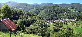
A general view of Alos | |
 Alos | |
|
Location within Occitanie region  Alos | |
| Coordinates: 42°54′33″N 1°08′45″E / 42.9092°N 1.1458°ECoordinates: 42°54′33″N 1°08′45″E / 42.9092°N 1.1458°E | |
| Country | France |
| Region | Occitanie |
| Department | Ariège |
| Arrondissement | Saint-Girons |
| Canton | Saint-Girons |
| Intercommunality | Val-Couserans |
| Government | |
| • Mayor (2014–2020) | Alain Tortet |
| Area1 | 24.26 km2 (9.37 sq mi) |
| Population (2010)2 | 130 |
| • Density | 5.4/km2 (14/sq mi) |
| Time zone | CET (UTC+1) |
| • Summer (DST) | CEST (UTC+2) |
| INSEE/Postal code | 09008 / 09200 |
| Elevation |
553–1,874 m (1,814–6,148 ft) (avg. 650 m or 2,130 ft) |
|
1 French Land Register data, which excludes lakes, ponds, glaciers > 1 km² (0.386 sq mi or 247 acres) and river estuaries. 2 Population without double counting: residents of multiple communes (e.g., students and military personnel) only counted once. | |
Alos is a French commune in the Ariège department in the Occitanie region of southwestern France.
The inhabitants of the commune are known as Alosiens or Alosiennes[1]
Geography
Alos is located some 100 km south by south-west of Toulouse, about 40 km west of Foix, and about 10 km north of the Spanish border. It is a high mountain commune with only three tortuous access roads: the D37 branching west from the D3 south of Lacourt enters the commune in the northeast and continues to the village before continuing south-east to join the D17 road north of Seix. There is also the D137 road coming south-west from Moulis which enters the commune in the north and joins the D37 near the village. Apart from Alos there are the hamlets of Artiguenard and La Riviere in the commune. There are numerous small country roads throughout much of the commune which consists mainly of mountain slopes and forests.[2]
The Riviere d'Alois flows out of the north-east to join the Salat river to the east. Numerous streams feed into the Alois including the Raven de Guerbrens which forms part of the eastern border and the Ruisseau de Argeniere which flows from the south of the commune. Many other streams flow into the Alois from all corners of the commune.[2]
Neighbouring communes and villages[2]
 |
Moulis | Saint-Girons | Lacourt | |
| Castillon-en-Couserans | |
Soueix-Rogalle | ||
| ||||
| | ||||
| Bethmale | Seix |
Administration
List of Successive Mayors of Alos[3]
| From | To | Name | Party | Position |
|---|---|---|---|---|
| 2001 | 2014 | André Pujol | ||
| 2014 | 2020 | André Pujol |
(Not all data is known)
Demography
In 2010, the commune had 130 inhabitants. The evolution of the number of inhabitants is known through the population censuses conducted in the town since 1793. From the 21st century, a census of municipalities with fewer than 10,000 inhabitants is held every five years, unlike larger towns that have a sample survey every year.[Note 1]
| 1793 | 1800 | 1806 | 1821 | 1831 | 1836 | 1841 | 1846 | 1851 |
|---|---|---|---|---|---|---|---|---|
| 789 | 752 | 925 | 990 | 1,005 | 1,214 | 1,210 | 1,258 | 1,173 |
| 1856 | 1861 | 1866 | 1872 | 1876 | 1881 | 1886 | 1891 | 1896 |
|---|---|---|---|---|---|---|---|---|
| 987 | 1,035 | 1,009 | 1,060 | 1,109 | 1,112 | 1,109 | 1,088 | 1,062 |
| 1901 | 1906 | 1911 | 1921 | 1926 | 1931 | 1936 | 1946 | 1954 |
|---|---|---|---|---|---|---|---|---|
| 1,028 | 1,023 | 885 | 779 | 722 | 625 | 546 | 463 | 365 |
| 1962 | 1968 | 1975 | 1982 | 1990 | 1999 | 2006 | 2009 | 2010 |
|---|---|---|---|---|---|---|---|---|
| 305 | 260 | 212 | 173 | 136 | 131 | 114 | 128 | 130 |
Sources : Ldh/EHESS/Cassini until 1962, INSEE database from 1968 (population without double counting and municipal population from 2006)

See also
External links
- Alos on the old National Geographic Institute website (French)
- Alos on Lion1906
- on Google Maps
- Alos on Géoportail, National Geographic Institute (IGN) website (French)
- Alos on the 1750 Cassini Map
- Alos on the INSEE website (French)
- INSEE (French)
Notes and references
Notes
- ↑ At the beginning of the 21st century, the methods of identification have been modified by law No. 2002-276 of 27 February 2002 , the so-called "law of local democracy" and in particular Title V "census operations" which allow, after a transitional period running from 2004 to 2008, the annual publication of the legal population of the different French administrative districts. For municipalities with a population greater than 10,000 inhabitants, a sample survey is conducted annually, the entire territory of these municipalities is taken into account at the end of the period of five years. The first "legal population" after 1999 under this new law came into force on 1 January 2009 and was based on the census of 2006.
References
- ↑ Inhabitants of Ariège (French)
- 1 2 3 Google Maps
- ↑ List of Mayors of France (French)
| Wikimedia Commons has media related to Alos, Ariège. |