Aldenham Reservoir
| Aldenham Reservoir | |
|---|---|
 | |
| Location | Hertfordshire |
| Coordinates | 51°38′45″N 0°18′40″W / 51.64583°N 0.31111°WCoordinates: 51°38′45″N 0°18′40″W / 51.64583°N 0.31111°W |
| Type | reservoir |
| Basin countries | United Kingdom |
| Surface area | 55 acres (220,000 m2) |

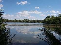
Aldenham Reservoir is situated in the parish of Elstree and Borehamwood in Hertfordshire, England, about one mile (1.6 km) to the west of the village of Elstree.
Originally, it was 65 acres (260,000 m2) in extent [now 55 acres (220,000 m2) after repairs to the dam] and was built by the Grand Junction Canal Company to control the water levels in the River Colne following the construction of the Grand Junction Canal. It was hand dug by French prisoners of war between 1795 and 1797.[1][2]
It is the source of the stream, Tykes Water, that runs north through Radlett. Nearby is the much larger Hilfield Park Reservoir, a nature reserve owned by Veolia Water.
It now forms the centre piece of the Aldenham Country Park and is used for recreational purposes, fishing and sailing. Aldenham Sailing Club is based here. Aldenham SC is a dinghy racing club, sailing mostly Laser, Enterprise, and RS300 dinghies.
-

Aldenham Sailing Club, Aldenham Reservoir, Elstree, Herts.
The very active club is also home to one of the largest fleets of Illusion mini-keelboats and it has a substantial Optimist ('Oppie') fleet. Aldenham SC is RYA affiliated, an RYA Volvo Champion Club and a recognized RYA Training Centre, providing a valuable service to the local community (see webcam and weather station: ).
References
- ↑ Hertsmere Borough Council: tourism and travel
- ↑ Herts Direct: Borehamwood Plateau: Physical Influences: Hydrology