Albert I Land
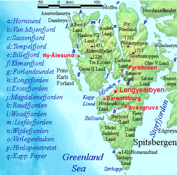
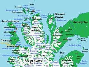

Albert I Land is the land area of the northwestern part of Spitsbergen, Svalbard.[1] It is bordered by Haakon VII Land[2] to the southeast. To the northeast lies Raudfjorden and its inner branch, Klinckowströmfjorden, to the southeast Krossfjorden and its inner branch, Lilliehöökfjorden, to the west and north the Arctic Ocean.
Albert I Land is the part of Spitsbergen that was first observed by Willem Barentz in 1596. Currently uninhabited, several geographical names stem from the history of whaling in the area during the 17th century. The area is named after Albert I, Prince of Monaco,[3] in honor of his exploration of Spitsbergen, and in particular this area in 1898-1907.
The Hornemantoppen mountain is the highest peak in Albert I Land.[4]
References
- ↑ Henriksen, Petter (ed.). "Albert I Land". Store norske leksikon (in Norwegian). Oslo: Kunnskapsforlaget. Retrieved 12 November 2011.
- ↑ "Haakon VII Land". Norwegian Polar Institute. Retrieved 12 November 2011.
- ↑ "Albert I Land". Norwegian Polar Institute. Retrieved 12 November 2011.
- ↑ Lauritzen, Per Roger, ed. (2009). "Albert I Land". Norsk Fjelleksikon (in Norwegian). Arendal: Friluftsforlaget. ISBN 978-82-91-49547-7.
.jpg)
Coordinates: 79°33′08″N 11°28′10″E / 79.55222°N 11.46944°E