Albert Canal
| Albert Canal | |
|---|---|
|
| |
| Specifications | |
| Length | 80.5 miles (129.6 km) |
| Locks | 6 |
| History | |
| Construction began | 1930 |
| Date of first use | 1939 |
| Geography | |
| Start point | Liège |
| End point | Antwerp |


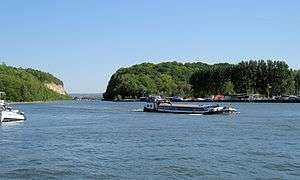
The Albert Canal (Dutch: Albertkanaal, French: Canal Albert) is a canal located in northeastern Belgium, which was named for King Albert I of Belgium. The Albert Canal connects Antwerp with Liège, and also the Meuse River with the Scheldt River. It also connects with the Canal Dessel-Turnhout-Schoten, and its total length is 129.5 kilometres (80.5 mi).
Size and geography
The Albert Canal has a standard depth of 3.4 metres (11 ft) and an overhead clearance of 6.7 metres (22 ft). To allow four-stacked container traffic, bridges over the canal are currently being heightened to allow for a 9.1 metres (30 ft) overhead.
The largest vessels that can use this canal are barges of just 10,000 tons - much smaller than the ones on the Rhine or the Danube or the ones in the waterways of the United States and Canada.
Between Antwerp and Liège, there is a difference in elevation of 56 metres (184 ft), and six sets of canal locks were needed to overcome this difference. Five canal locks each have a lift of 10 metres (33 ft), and these are located in Genk, Diepenbeek, Hasselt, Kwaadmechelen, and Olen, Belgium. The sixth lock at Wijnegem has a lift of 5.45 metres (17.9 ft).
During most of the 1930s, before the completion of the Albert Canal, it took about seven days to travel from Antwerp to Liege by water. In the 21st century, that same distance can be covered in about 18 hours.
History


The Albert Canal was constructed from 1930 through 1939. The German construction company Hochtief AG worked on the canal between 1930 and 1934, but it was completed by Belgian companies. The Albert Canal was used for the first time in 1940 but, because of World War II and the German occupation, intensive use only began later, in 1946.
During World War II, the Albert Canal functioned as a defense line. The crossing of the canal by the German forces and the destruction of Fort Eben-Emael on 11 May 1940 was a milestone in the German invasion of Belgium.
During the Liberation of Belgium by the Allies in September 1944, the Second Canadian Division was the first Allied unit to cross the Albert Canal. The British Army also crossed the Albert Canal on its way north across Belgium and into The Netherlands and the U.S. Army entered Belgium further to the east on its way to liberate the rest of Belgium, and Luxembourg, and then proceed east to invade Nazi Germany. Hence, Belgium was liberated from the south by three different armies, two of which needed to cross the Albert Canal.
Today
In 2002, the canal carried a record 43 million tons of goods of various kinds, amounting to more than half the Belgian waterway total. [1]
The canal is also a popular leisure and cycling destination, with well paved service roads on both sides traversing picturesque farm land, particularly around Smeermass, Lanaken and Maasmechelen. [1]
Notes
- 1 2 "Cycling Belgium's Waterways: Albert Canal", Gamber.net, retrieved 10 October 2015
Coordinates: 51°04′03″N 5°11′27″E / 51.0674°N 5.1907°E