Ajaokuta
| Ajaokuta Ajaokuta, Kogi State. | |
|---|---|
|
Ajaokuta Steel Rolling Mill, which manufactures iron materials | |
 | |
| Coordinates: 7°33′22″N 6°39′18″E / 7.55611°N 6.65500°E | |
| Country |
|
| State | Kogi State |
| Area | |
| • Total | 1,362 km2 (526 sq mi) |
| Population (2006 Census) | |
| • Total | 122,321 |
| Time zone | WAT (UTC+1) |
| 3-digit postal code prefix | 263 |
| ISO 3166 code | NG.KO.AJ |

Ajaokuta is a Local Government Area in Kogi State, Nigeria and a town within it on the left bank of the Niger River. The headquarters of the LGA are in the town of Egayin in the south of the area at 6°40′11″N 8°48′19″E / 6.66972°N 8.80528°E.
It has an area of 1,362 km² and a population of 122,321 at the 2006 census.
The postal code of the area is 263.[1]
As of 2008 Ajaokuta, the town, had an estimated population of 16,039.[2]
It is the home of the multibillion-dollar Ajaokuta Steel Rolling Mill. Ajaokuta Steel Project is located on 24,000 hectares of sprawling green-field land-mass. The Steel Plant itself is built on 800-hectares of land. The chosen Technology for Steel Production is the time tested Blast-Furnace – Basic Oxygen Furnace route for Steel Production. The complex is meant to be used to generate important upstream and downstream industrial and economic activities that are critical to the diversification of the Nigerian economy into an industrial one. Ajaokuta Steel Plant is therefore aptly tagged as the “Bedrock of Nigeria’s industrialization”.[3]
Transport
It is not as yet connected to the main railway system of Nigeria, except by river. An isolated standard gauge railway connects the steelworks to its source of iron ore at Itakpe. A connection of this railway to the port of Warri is unfinished.
See also
References
- ↑ "Post Offices- with map of LGA". NIPOST. Archived from the original on 7 October 2009. Retrieved 2009-10-20.
- ↑ "The World Gazetteer". Archived from the original on 2012-02-24. Retrieved 2007-04-03.
- ↑ Reviving Ajaokuta Steel Mill Archived April 13, 2014, at the Wayback Machine.
External links
Coordinates: 07°33′22″N 06°39′18″E / 7.55611°N 6.65500°E
State capital: Lokoja | ||
| LGAs | 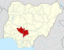 | |