Aith

Coordinates: 60°17′02″N 1°22′44″W / 60.284°N 1.379°W
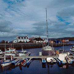
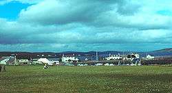
Aith, (Shetland dialect: Eid, Old Norse: Eið, meaning Isthmus, cf Eday), is a village on the Northern coast of the West Shetland Mainland at the southern end of Aith Voe, some 21 miles west of Lerwick.[1][2]
Aith lies on the B9071 that runs south to the junction with the A971 (which links Lerwick to the west of Shetland) at the village of Bixter and North East via East Burrafirth to the junction with the A970 (which links Lerwick to the North) at the village of Voe. A single track road leads north from Aith along the west shoreline of Aith Voe to Vementry.[3]
Every year in early June the Aith Lifeboat Gala is held to raise money for the Royal National Lifeboat Institution, featuring a jarl squad and displays by the Shetland Coastguard among other activities.[4][5]
History
The modern settlement occupies an area originally named Aithsting during the period of Norse occupation. The surrounding Parish is still known as Aithsting.[6][7]
Buildings and structures
- Aith Lifeboat Station is most northerly in Britain, established in 1933.[8]
- Aith Junior High School is situated in the centre of the village. The school has nursery, primary, and secondary departments with a combined roll of around 190 - 200. The secondary roll includes pupils from Sandness, Skeld, Happyhansel and Aith primary schools. The original school building, which opened in 1922 and became a Junior High in 1970, was located on the east of the main settlement, below the junction of the B9071 and Whitelaw Road. The school relocated to a new building in the more central location in 1982[3][9][10] 60°17′02″N 1°22′39″W / 60.28389°N 1.37750°W
- West Mainland Leisure Centre, opened on 7 September 2002 and is operated by Shetland Recreational Trust. Facilities include a main hall, squash court, swimming pool with paddling pool, fitness suite and health suite.[11]
- Aith Marina
- Aith Community Hall, incorporating the Rankin Lounge.
Notable residents
John Nicolson was a late 19th / early 20th century writer and political activist. His first book was entitled Sprigs o' Aithstin Heather[12] was published in Lerwick in 1898. He wrote the words for The Galley Song which is sung annually at Up-Helly-Aa.[13][14]
Notable events
On 20 February 2008 several houses in Aith were evacuated due to a fire in the local garage prompting fears that oxyacetylene canisters stored there may explode. The garage was destroyed and the site later cleared.[15]
References
- ↑ Groome, Francis Hindes, ed. (1901) [1901]. "Ordnance gazetteer of Scotland : a graphic and accurate description of every place in Scotland". National Library of Scotland. Edinburgh: National Library of Scotland. pp. 38–39. Retrieved 2016-01-23.
- ↑ Ordnance Survey. "View: Sheet 2, Shetland Islands (North Mainland) - Ordnance Survey One-inch to the mile maps of Great Britain, Seventh Series, 1952-1961". National Library of Scotland. National Library of Scotland. Retrieved 2016-01-23.
- 1 2 "Aith Junior High School - Travel Plan" (PDF). Shetland Islands Council. Archived from the original (PDF) on 19 February 2012. Retrieved 6 April 2009.
- ↑ "Lifeboat Gala day a huge success in Aith". RNLI. Retrieved 27 August 2013.
- ↑ "Sun shines on Aith lifeboat gala". Shetland News. Shetland News. 3 June 2013. Retrieved 2016-01-23.
- ↑ Holman, Katherine (2007). The Northern Conquest: Vikings in Britain and Ireland. Signal Books. p. 169. ISBN 9781904955344.
- ↑ "Sandsting & Aithsting Proposals Map" (PDF). Shetland Islands Council. Retrieved 6 April 2009.
- ↑ "Lifeboat Station: Aith". RNLI. Archived from the original on 3 January 2009. Retrieved 6 April 2009.
- ↑ "Welcome to Aith Junior High School". Aith Junior High School. Retrieved 6 April 2009.
- ↑ "Aith Junior High School, Bixter". Schoolsnet. Retrieved 6 April 2009.
- ↑ "West Mainland Leisure centre". Shetland Recreational Trust. Retrieved 6 April 2009.
- ↑ NICOLSON, John (1898). Sprigs o'Aithstin' Heather. [Tales.].
- ↑ "History and Culture - Up Helly Aa" (PDF). Shetland Guide. Retrieved 6 April 2009.
- ↑ Nicolson, John. "The Galley Song". Tobar an Dualchais. Retrieved 2016-01-23.
- ↑ "Aith citizens forced to evacuate village". STV. Archived from the original on 25 October 2008. Retrieved 21 February 2008.
External links
| Wikimedia Commons has media related to Aith. |
| Inhabited islands | ||
|---|---|---|
| Other islands | ||
| Towns and villages | ||
| Mainland Parishes | ||
| Maritime features | ||
Extreme points
| ||
| Topics | ||