Aiguille du Tour
| Aiguille du Tour | |
|---|---|
|
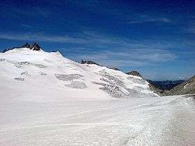
Aiguille du Tour (left) from the east side | |
| Highest point | |
| Elevation | 3,540 m (11,610 ft) |
| Prominence | 259 m (850 ft) [1] |
| Coordinates | 45°59′39.9″N 7°0′35.4″E / 45.994417°N 7.009833°ECoordinates: 45°59′39.9″N 7°0′35.4″E / 45.994417°N 7.009833°E |
| Geography | |
 Aiguille du Tour Location in the Alps | |
| Location |
Valais, Switzerland Haute-Savoie, France |
| Parent range | Mont Blanc Massif |
| Climbing | |
| First ascent | M. Dreyfus, R. Duval, P. Henry, and M. Ichac in 1926 |
The Aiguille du Tour (3,540 metres (11,614 ft)) is a mountain in the Mont Blanc massif, located on the border between Switzerland and France. The voie normale on the mountain is graded F (facile) and can be climbed from either the Albert Premier Hut on the French side or the Trient Hut on the Swiss side.
The Aiguille du Pissoir (3,440 m) and the Aiguille Purtscheller (3,475 m) are secondary summits located respectively north and south of the Aiguille du Tour.
References
External links
This article is issued from Wikipedia - version of the 5/23/2016. The text is available under the Creative Commons Attribution/Share Alike but additional terms may apply for the media files.