Aidanfield
| Aidanfield | |
|---|---|
 Location of Aidanfield within Christchurch | |
| Basic information | |
| Local authority | Christchurch City Council |
| Electoral ward | Riccarton-Wigram |
| Date established | 2001 |
| Population | 2400 (2010) |
| Surrounds | |
| North | Middleton |
| Northeast | Hillmorton |
| Southeast | Halswell |
| South | Oaklands |
| Northwest | Wigram |
Aidanfield is a new suburb in the south-west of Christchurch, New Zealand, about 8 kilometres (5.0 mi) from the city centre. The land, which had been owned by the Good Shepherd Sisters since 1886[1] now incorporates the Mount Magdala Institute and the St John of God Chapel, which has a Category I heritage listing by the New Zealand Historic Places Trust. The first residents moved into the suburb in 2002. The developer caused controversy in 2007–2008 by applying to have a group of farm buildings demolished to allow for further subdivision. Christchurch City Council was widely criticised for approving the demolition despite the buildings having had a heritage listing in the Christchurch City Plan.
Geography
Aidanfield is located between Halswell Road (State Highway 75), Dunbars Road, the Christchurch Southern Motorway, the Canterbury Agricultural Park (home of the Canterbury A&P Show) and Templetons Road.[2]
The centre of Aidanfield is about 8 kilometres (5.0 mi) from Christchurch city centre.[3]
Historic background
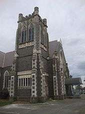
Father Laurence Ginaty established the Mount Magdala Institute in 1886 to provide a home for women and girls. It developed into an institution caring for women recently released from prison, orphans, and "unruly girls". Numerous buildings were constructed, and at its peak in the 1930s, 500 people lived on the complex. The St John of God Chapel, designed by Sidney and Alfred Luttrell and now listed as a Category I heritage structure by the New Zealand Historic Places Trust, was completed in 1912.[4]
The Catholic order owned all the land around Mount Magdala, and decided to develop most of it as a subdivision to provide them with financial support.[5] The Press first reported in mid-2000 on the subdivision plans.[6]
Naming
The suburb is named after Mother Aidan Phelan (1858–1958), the Superior at Mount Magdala from 1907 to 1920 and again from 1929 to 1936. Mother Aidan was herself named after the Irish saint Aidan of Lindisfarne. The name Aidanfield was approved on 31 January 2001.[7][8]
Subdivision development and amenities
The first residents moved into Aidanfield in 2002, and by 2011 some 400 sections had been built on;[9] when the subdivision is fully developed, more than 50 new roads will have been created.[7] The 2006 census reported 1320 residents in the Aidanfield area unit.[10] Statistics New Zealand have estimated the suburb's 2010 population at 2400 residents.[11]

The subdivision developer caused controversy in 2007 after applying to have four of the five historic Madgala Farm buildings demolished to make way for further subdivision.[12] Although the buildings were protected in the Christchurch City Council District Plan, councillors voted eight to four in favour of granting demolition consent.[13] Staff advice to councillors had been that the "farm buildings in their current form have high regional and moderate national heritage significance and therefore should be considered with the Deans’ farm buildings to be the most significant heritage farm buildings remaining in Christchurch."[14] The consent was appealed by Environment Canterbury and the Halswell Residents' Association to the Environment Court, with the New Zealand Historic Places Trust as a supporting party, but the demolition went ahead.[15]
The Halswell Residential College is a school for boys with learning difficulties, from years 7 to 10. Located on Mount Magdala land, the school had a roll of 74 in 2011 and is decile 2.[16][17] Since the 2011 Christchurch earthquake, Discovery 1 School and Unlimited Paenga Tawhiti (UPT) have also been using the campus of this school, as they were displaced from the central city. UPT will move to Ilam in 2013, whilst Discovery 1 will remain at the Halswell Residential College.[18]
Aidanfield Christian School is a state-integrated school for years 1 to 10. Also on Mount Magdala land, it had a roll of 169 in 2011 and is decile 7.[19][20]
There are no shopping facilities in Aidanfield; the nearest shops are in neighbouring Halswell, about 2.5 kilometres (1.6 mi) away.[21]
References
- ↑ ,"The Good Shepherd Sisters in Australia". Congregation of Our Lady of Charity of the Good Shepherd. Retrieved 12 October 2011.
- ↑ "Location". Aidanfield. Retrieved 2 October 2011.
- ↑ "Get directions". Google Maps. Retrieved 2 October 2011.
- ↑ "St John of God Chapel". Register of Historic Places. Heritage New Zealand. Retrieved 2 October 2011.
- ↑ Harper, Margaret (July 2011). "Christchurch Place Names" (PDF). Christchurch City Libraries. p. 5. Retrieved 2 October 2011.
- ↑ "Catholic land may become suburb". The Press. 28 July 2000. p. 6.
- 1 2 Pritchard, Bob (31 January 2001). "Proposed New Road Names" (PDF). Christchurch City Council. Retrieved 28 July 2015.
- ↑ "Minutes of a Meeting of the Christchurch City Council held at 2pm on Thursday 22 February 2001" (PDF). Christchurch City Council. 22 February 2001. p. 6. Retrieved 28 July 2015.
- ↑ "About Aidanfield". Aidanfield. Retrieved 2 October 2011.
- ↑ "QuickStats About Aidanfield". Statistics New Zealand. Retrieved 2 October 2011.
- ↑ "Interactive Boundary Maps". Statistics New Zealand. Retrieved 2 October 2011.
- ↑ "Developers target farm buildings". stuff.co.nz. 12 September 2007. Retrieved 2 October 2011.
- ↑ "Decision angers heritage campaigners". The Press. 25 April 2008. Retrieved 2 October 2011.
- ↑ Carrie, Neil (27 September 2007). "Aidanfield Heritage Farm Buildings" (PDF). Christchurch City Council. p. 3. Retrieved 27 July 2015.
- ↑ Carrie, Neil (24 April 2008). "Aidanfield Farm Buildings" (PDF). Christchurch City Council. Retrieved 27 July 2015.
- ↑ "Halswell Residential College". Te Kete Ipurangi. Retrieved 2 October 2011.
- ↑ "Welcome to Halswell Residential College". Halswell Residential College. Retrieved 2 October 2011.
- ↑ Mann, Charley (14 November 2012). "Unlimited to move to uni campus". The Press. Retrieved 15 November 2012.
- ↑ "Aidanfield Christian School". Te Kete Ipurangi. Retrieved 2 October 2011.
- ↑ "About Aidanfield Christian School". Halswell Residential College. Retrieved 2 October 2011.
- ↑ "Get directions". Google Maps. Retrieved 2 October 2011.
External links
Coordinates: 43°33′54″S 172°34′08″E / 43.565°S 172.569°E