Agrifina Circle
| Agrifina Circle | |
|---|---|
| Teodoro F. Valencia Circle (official) | |
 | |
| Location | |
| Rizal Park, Ermita, Manila, Philippines | |
| Roads at junction: |
General Luna Street Minor roads inside Rizal Park |
| Construction | |
| Type: | Traffic circle |
The Agrifina Circle, officially the Teodoro F. Valencia Circle is a traffic circle within the eastern portion of Rizal Park in Manila, the Philippines.[1]
Etymology
The name "Agrifina" is a portmanteau of the words "Agriculture" and "Finance" since two neoclassical buildings located on opposite ends of the circle formerly housed the Departments of Agriculture and Finance. The former building of the Department of Agriculture today houses the Museum of the Filipino People, while the former building of the Department of Finance formerly housed the Department of Tourism until 2015, when the building was vacated to make way for the new Museum of Natural History.
The circle was officially renamed to Teodoro F. Valencia Circle in January 5, 1990 through Republic Act No. 6836.[2]
History
The Agrifina Circle was intended to be a grand civic plaza linking the planned National Capital Building to five wedge shaped buildings which included the Finance and Agriculture Buildings.
After World War II, when it was decided that the capital of the Philippines was to be moved to Quezon City, the then-plaza was converted into a rotonda. Vehicular traffic was allowed in road until the late 1960s when Rizal Park was consolidated and most roads going through the park were pedestrianized. A fountain and skating rink was installed at the central island.[3]
There were plans to construct a 390 metres (1,280 ft) observation tower, the Luneta Tower at the Agrifina Circle for the Centennial celebration of Philippine Independence in 1998. The decision to build the tower at the site, however, was controversial and the plan was eventually shelved.
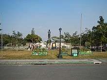
By the year 2000, the Binhi ng Kalayaan Monument was at the former site of the fountain with the skating rink still present.[1]
The Sentinel of Freedom, a monument dedicated to Lapu-Lapu replaced the structure in 2004.
Layout
| Eastern side | ||||
| Taft Avenue | ||||
| Binhi ng Kalayaan Garden |
* |  Relief Map of the Philippines |
* |  Children's Park |
| Road | Agrifina Circle | General Luna Street | ||
Museum of the Filipino People |
 Sentinel of Freedom |
 Department of Tourism Building | ||
| Road | Agrifina Circle | Road | ||
 Orchidarium |
* |  Bisig Marker |
* | National Parks Development Committee Compound |
| Maria Y. Orosa Street | ||||
| Rest of Rizal Park | ||||
| Western side | ||||
| Note: (*) Footpath | ||||
References
- 1 2 Aning, Jerome; Rivera, Blanche (7 May 2000). "Blast rocks Rizal Park". Philippine Daily Inquirer. Retrieved 29 July 2016.
- ↑ "REPUBLIC ACT NO. 6836 - AN ACT CHANGING THE NAME OF THE AGRIFINA CIRCLE, A CIRCULAR ROAD NEAR THE LUNETA PARK IN THE CITY OF MANILA, TO TEODORO F. VALENCIA CIRCLE". Chan Robles Virtual Law Library. 5 January 1990. Retrieved 29 July 2016.
- ↑ Alcazaren, Paulo (14 July 2001). "Rotundas: Circles of urban life". City Sense. Philippine Daily Inquirer. Retrieved 29 July 2016.
Luneta National Park | ||||||||||||
| Features |
|  | ||||||||||
| Neighboring features |
| |||||||||||
| Events | ||||||||||||
| Miscellaneous | ||||||||||||