Agra, Kansas
| Agra, Kansas | |
|---|---|
| City | |
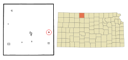 Location within Phillips County and Kansas | |
 KDOT map of Phillips County (legend) | |
| Coordinates: 39°45′38″N 99°7′11″W / 39.76056°N 99.11972°WCoordinates: 39°45′38″N 99°7′11″W / 39.76056°N 99.11972°W | |
| Country | United States |
| State | Kansas |
| County | Phillips |
| Area[1] | |
| • Total | 0.27 sq mi (0.70 km2) |
| • Land | 0.27 sq mi (0.70 km2) |
| • Water | 0 sq mi (0 km2) |
| Elevation | 1,850 ft (564 m) |
| Population (2010)[2] | |
| • Total | 267 |
| • Estimate (2015)[3] | 247 |
| • Density | 990/sq mi (380/km2) |
| Time zone | Central (CST) (UTC-6) |
| • Summer (DST) | CDT (UTC-5) |
| ZIP code | 67621 |
| Area code(s) | 785 |
| FIPS code | 20-00550 [4] |
| GNIS feature ID | 0471935 [5] |
Agra is a city in Phillips County, Kansas, United States. As of the 2010 census, the city population was 267.[6]
History
Agra was first settled in 1888, and incorporated in 1904.[7] Agra was a station on the Chicago, Rock Island and Pacific Railroad.[8]
Geography
Agra is located at 39°45′38″N 99°7′11″W / 39.76056°N 99.11972°W (39.760686, -99.119592).[9] According to the United States Census Bureau, the city has a total area of 0.27 square miles (0.70 km2), all land.[1]
Demographics
| Historical population | |||
|---|---|---|---|
| Census | Pop. | %± | |
| 1910 | 347 | — | |
| 1920 | 361 | 4.0% | |
| 1930 | 408 | 13.0% | |
| 1940 | 406 | −0.5% | |
| 1950 | 354 | −12.8% | |
| 1960 | 277 | −21.8% | |
| 1970 | 294 | 6.1% | |
| 1980 | 321 | 9.2% | |
| 1990 | 322 | 0.3% | |
| 2000 | 306 | −5.0% | |
| 2010 | 267 | −12.7% | |
| Est. 2015 | 247 | [3] | −7.5% |
| U.S. Decennial Census | |||
2010 census
As of the census[2] of 2010, there were 267 people, 116 households, and 78 families residing in the city. The population density was 988.9 inhabitants per square mile (381.8/km2). There were 162 housing units at an average density of 600.0 per square mile (231.7/km2). The racial makeup of the city was 95.1% White, 0.4% African American, 1.9% Native American, 0.4% Asian, and 2.2% from two or more races. Hispanic or Latino of any race were 2.2% of the population.
There were 116 households of which 25.0% had children under the age of 18 living with them, 56.0% were married couples living together, 6.0% had a female householder with no husband present, 5.2% had a male householder with no wife present, and 32.8% were non-families. 30.2% of all households were made up of individuals and 13.8% had someone living alone who was 65 years of age or older. The average household size was 2.30 and the average family size was 2.86.
The median age in the city was 49.4 years. 23.2% of residents were under the age of 18; 6.4% were between the ages of 18 and 24; 14.6% were from 25 to 44; 36.7% were from 45 to 64; and 19.1% were 65 years of age or older. The gender makeup of the city was 51.3% male and 48.7% female.
2000 census
As of the census[4] of 2000, there were 306 people, 131 households, and 89 families residing in the city. The population density was 1,099.6 people per square mile (422.0/km²). There were 173 housing units at an average density of 621.7 per square mile (238.6/km²). The racial makeup of the city was 98.69% White, 0.33% Native American, and 0.98% from two or more races. Hispanic or Latino of any race were 0.65% of the population.
There were 131 households out of which 31.3% had children under the age of 18 living with them, 56.5% were married couples living together, 9.9% had a female householder with no husband present, and 31.3% were non-families. 29.8% of all households were made up of individuals and 14.5% had someone living alone who was 65 years of age or older. The average household size was 2.34 and the average family size was 2.89.
In the city the population was spread out with 28.4% under the age of 18, 3.9% from 18 to 24, 24.5% from 25 to 44, 26.5% from 45 to 64, and 16.7% who were 65 years of age or older. The median age was 39 years. For every 100 females there were 91.3 males. For every 100 females age 18 and over, there were 90.4 males.
The median income for a household in the city was $27,250, and the median income for a family was $36,250. Males had a median income of $26,944 versus $16,429 for females. The per capita income for the city was $16,960. About 8.5% of families and 10.7% of the population were below the poverty line, including 11.3% of those under the age of eighteen and 7.7% of those sixty five or over.
References
- 1 2 "US Gazetteer files 2010". United States Census Bureau. Archived from the original on 2012-01-24. Retrieved 2012-07-06.
- 1 2 "American FactFinder". United States Census Bureau. Retrieved 2012-07-06.
- 1 2 "Annual Estimates of the Resident Population for Incorporated Places: April 1, 2010 to July 1, 2015". Retrieved July 2, 2016.
- 1 2 "American FactFinder". United States Census Bureau. Archived from the original on 2013-09-11. Retrieved 2008-01-31.
- ↑ "US Board on Geographic Names". United States Geological Survey. 2007-10-25. Retrieved 2008-01-31.
- ↑ "2010 City Population and Housing Occupancy Status". U.S. Census Bureau. Archived from the original on July 21, 2011. Retrieved September 18, 2011.
- ↑ Blackmar, Frank Wilson (1912). Kansas: A Cyclopedia of State History, Embracing Events, Institutions, Industries, Counties, Cities, Towns, Prominent Persons, Etc. Standard Publishing Company. p. 32.
- ↑ Gannett, Henry (1898). A Gazetteer of Kansas. Govt. Print. Off. p. 24.
- ↑ "US Gazetteer files: 2010, 2000, and 1990". United States Census Bureau. 2011-02-12. Retrieved 2011-04-23.
External links
| Wikimedia Commons has media related to Agra, Kansas. |
- City
- Schools
- USD 110, local school district
- Maps
- Agra City Map, KDOT
Municipalities and communities of Phillips County, Kansas, United States | ||
|---|---|---|
| Cities | 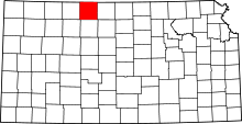 | |
| Unincorporated communities | ||