Agistri
| Agistri Αγκίστρι | |
|---|---|
|
Beach of Skala | |
 Agistri | |
|
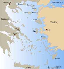
Location within the region  | |
| Coordinates: 37°42′N 23°20′E / 37.700°N 23.333°ECoordinates: 37°42′N 23°20′E / 37.700°N 23.333°E | |
| Country | Greece |
| Administrative region | Attica |
| Regional unit | Islands |
| Government | |
| • Mayor | Ioannis Athanasiou (Ind.) |
| Area | |
| • Municipality | 13.37 km2 (5.16 sq mi) |
| Population (2011)[1] | |
| • Municipality | 1,142 |
| • Municipality density | 85/km2 (220/sq mi) |
| Time zone | EET (UTC+2) |
| • Summer (DST) | EEST (UTC+3) |
| Postal code | 180 10 |
| Area code(s) | 22970 |
| Vehicle registration | Z |
| Website |
agistri-island |

Agistri, also Angistri or Agkistri (Greek: Αγκίστρι [aɲˈɟistɾi ~ aˈɟistɾi], English: "fishing hook"), is a small island and municipality in the Saronic Gulf in the Islands regional unit, Greece.
Settlements

There are only three settlements on Agistri - Milos (Megalochori), Skala and Limenaria. Milos (pop. 566) is the main village where the majority of the Greek population of the island lives. Skala (pop. 448) is a twenty-minute walk from Milos along the coastal road. Skala is where most of the tourist facilities and hotels are. Limenaria (pop. 128) is a very small village on the other side of the island with very little tourism. The island's population is 1,142 inhabitants according to the 2011 Greek census. Its land area is 13.367 km2 (5.161 sq mi).[2]
Geography
Agistri is a pine-covered island in the Saronic Islands group.
Agistri is very close to the larger Saronic island of Aegina. The island can be reached from Aegina by a number of boats in just ten minutes. These boats include the Agistri Express and a number of small "water taxis". The island is also an hour's boat ride from the large Athenian port of Piraeus.
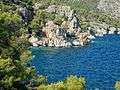
Gallery
-

Path at Mareza
-
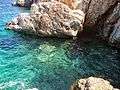
Mareza,Agistri island
-

Μareza,Agistri
-

Mareza,Agistri
-
Mareza,Agistri
-
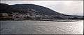
Panoramic image of the harbor of Agistri island.
-

The harbor/beach of Skala, Agistri island.
-

Panoramic image of the beach of Skala and the harbor of Agistri island.
-

Village Limenaria / Agistri island.
-

Fishing boat and nets at Megalochori, Agkistri Island, Greece.
-

The Church of Agioi Anargyroi from the beach located near the small port town of Skala
-
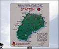
Map of Agistri on a forest fire warning sign
References
- ↑ "Απογραφή Πληθυσμού - Κατοικιών 2011. ΜΟΝΙΜΟΣ Πληθυσμός" (in Greek). Hellenic Statistical Authority.
- ↑ "Population & housing census 2001 (incl. area and average elevation)" (PDF) (in Greek). National Statistical Service of Greece.
External links
| Wikimedia Commons has media related to Angistri. |
Administrative division of the Attica Region | ||
|---|---|---|
| Regional unit of Central Athens |  | |
| Regional unit of North Athens | ||
| Regional unit of West Athens | ||
| Regional unit of South Athens | ||
| Regional unit of Piraeus | ||
| Regional unit of East Attica | ||
| Regional unit of West Attica | ||
| Regional unit of Islands | ||
| ||