Achterveld
| Achterveld | |
|---|---|
| Village | |
 | |
 The village centre (dark green) and the statistical district (light green) of Achterveld in the municipality of Leusden. | |
| Coordinates: 52°8′10″N 5°29′49″E / 52.13611°N 5.49694°ECoordinates: 52°8′10″N 5°29′49″E / 52.13611°N 5.49694°E | |
| Country | Netherlands |
| Province | Utrecht |
| Municipality | Leusden |
| Population (2008)[1] | |
| • Total | 2,520 |
| Time zone | CET (UTC+1) |
| • Summer (DST) | CEST (UTC+2) |
| Website | www.achterveld.net |
Achterveld is a village in the central Netherlands. It is a part of the municipality of Leusden, Utrecht and is located about 8 km east of Amersfoort.
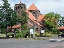
The village is a catholic enclave in a protestant region. It has a neo-romanic church.
In 2001, the village of Achterveld had 1616 inhabitants. The built-up area of the village was 0.50 km², and contained 651 residences.[2] The statistical area "Achterveld", which also can include the peripheral parts of the village, as well as the surrounding countryside, has a population of around 2570.[3]
On April 28 and 30, 1945, Achterveld was the scene of high-ranking talks now known as 'The Achterveld Conference' between the Allied command - a.o. the generals Bedell Smith of the United States), Foulkes of Canada), Sir Francis de Guingand of the United Kingdom, Prince Bernhard of the Netherlands, Ivan Susloparov of the Soviet Union and the occupying German government of the Netherlands, headed by 'Reichskomissar' Arthur Seyss-Inquart, and his aides. They discussed urgent food-help for the starving cities in the west of Holland, which Seyss-Inquart allowed, and which started the day after, April 29, by plane from England, code-named Operation Manna.
The Allies tried to start negotiations about an unconditional German surrender. Seyss-Inquart did not want to comply there and then, although a general cease-fire was convened. The Germans ceased their resistance only on May 5 following, in Wageningen. (Source: Dr Loe de Jong: Het Koninkrijk der Nederlanden in de Tweede Wereldoorlog ('The Kingdom of the Netherlands during the Second World War'), SDU, 1966–81).
References
- ↑ CBS Statline
- ↑ Statistics Netherlands (CBS), Bevolkingskernen in Nederland 2001 Archived March 19, 2006, at the Wayback Machine.. (Statistics are for the continuous built-up area).
- ↑ Statistics Netherlands (CBS), Statline: Kerncijfers wijken en buurten 2003-2005 Archived 2006-07-24 at WebCite. As of 1 January 2005.