Abusir
 Shown within Egypt | |
| Location | Egypt |
|---|---|
| Region | Cairo Governorate |
| Coordinates | 29°54′N 31°12′E / 29.9°N 31.2°E |
| |||||
| Busiri in hieroglyphs |
|---|
Abusir (Arabic: ابو صير Egyptian Arabic pronunciation: [æbuˈsˤiːɾ]; Egyptian pr wsjr; Coptic: ⲃⲟⲩⲥⲓⲣⲓ busiri, "the House or Temple of Osiris"; Ancient Greek: Βούσιρις) is the name given to an Egyptian archaeological locality – specifically, an extensive necropolis of the Old Kingdom period, together with later additions – in the vicinity of the modern capital Cairo. The name is also that of a neighbouring village in the Nile Valley, whence the site takes its name. Abusir is located several kilometres north of Saqqara and, like it, served as one of the main elite cemeteries for the ancient Egyptian capital city of Memphis. Several other villages in northern and southern Egypt are named Abusir or Busiri.
Abusir is one relatively small segment of the extensive "pyramid field" that extends from north of Giza to below Saqqara. The locality of Abusir took its turn as the focus of the prestigious western burial rites operating out of the then-capital of Memphis during the Old Kingdom 5th Dynasty. As an elite cemetery, neighbouring Giza had by then "filled up" with the massive pyramids and other monuments of the 4th Dynasty, leading the 5th Dynasty pharaohs to seek sites elsewhere for their own funerary monuments.
Abusir was the origin of the largest find of Old Kingdom papyri to date — the Abusir Papyri. In the late nineteenth century, a number of Western museums acquired collections of fragmentary papyri from the administrative (temple) records of one Abusir funerary cult, that of king Neferirkare Kakai. This discovery was supplemented in the late twentieth century when excavations by a Czech expedition to the site revealed papyri from two other cult complexes, that of the pharaoh Neferefre (also read Raneferef) and for the king's mother Khentkaus II.
The Czech Institute of Egyptology of the Faculty of Arts, Charles University in Prague has been conducting excavations at Abusir since 1976. They are presently directed by Miroslav Bárta.
There are considerable catacombs near the ancient town of Busiris (Pliny xxxvi. 12. s. 16). To the south of Busiris one great cemetery appears to have stretched over the plain. The Heptanomite Busiris was in fact a hamlet standing at one extremity of the necropolis of Memphis.
Necropolis
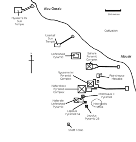
There are a total of 14 pyramids at this site, which served as the main royal necropolis during the Fifth dynasty. The quality of construction of the Abusir pyramids is inferior to those of the Fourth Dynasty; perhaps signalling a decrease in royal power or a less vibrant economy. They are smaller than their predecessors, and are built of low quality local stone. All of the major pyramids at Abusir were built as step pyramids, although the largest of them — the Pyramid of Neferirkare — is believed to have originally been built as a step pyramid some seventy metres in height and then later transformed into a "true" pyramid by having its steps filled in with loose masonry.
Major pyramids
The three major pyramids are
- the Pyramid of Neferirkare Kakai, the tallest pyramid at the site
- the Pyramid of Niuserre, the most intact pyramid at the site
- the Pyramid of Sahure known for its finely carved reliefs
Smaller pyramids
- the incomplete Pyramid of Neferefre
- the pyramid of Queen Khentkaus II, wife of Neferirkare and mother of Neferefre and Niuserre
- the unfinished pyramid of Shepseskaf? [1]
- Lepsius Pyramid no. 24 — The pyramid belonged to a woman, likely a queen. The name of the vizier Ptahshepses appears among builders' marks, which dates the pyramid to the time of Pharaoh Nyuserre [1]
- Lepsius Pyramid no. 25 — Likely the pyramid of a queen from the Fifth dynasty [1]
Mastabas of courtiers
The tombs of several high officials and family members are located in the direct vicinity of their king's pyramid:
- the mastaba of Ptahshepses (vizier under Nyuserre)
- the mastaba of Prince Nakhtkare (son of Raneferef or Nyuserre)
Abusir-south
Directly north of Saqqara is a cemetery of lower-ranking officials of the Old Kingdom, including the following tombs:
- the tomb of Ity (Dynasty 3)
- the tomb of Hetepi (priest, beginning of Dynasty 3)
- the tomb of Kaaper (architect and priest, Dynasty 4)
- the tomb of Rahotep (priest, end of Dynasty 5)
- the tomb of Fetekti (priest, end of Dynasty 5)
- the tomb of Qar and his sons (vizier, Dynasty 6)
- the rock cut tomb of Nakhtmin (charioteer)
Saite-Persian cemetery
On a small hill directly south of the pyramid of Neferefre is a cemetery of tombs from the Saite period:
- the tomb of Udjahorresnet
- the tomb of Iufaa
- the tomb of Menekhibneko
- the tomb of Padihor
- tomb R3
Site looting during 2011 protests
Abusir, Saqqara and Dahshur suffered damage by looters during the 2011 Egyptian protests. Part of the false door from the tomb of the priest Rahotep was stolen, and store rooms were broken into.[2][3]
Systematic looting continues into 2013 with organized digging and destruction of tombs and mummies.[4]
Climate
Köppen-Geiger climate classification system classifies it climate as hot desert (BWh),[5] as the rest of Egypt.
| Climate data for Abusir | |||||||||||||
|---|---|---|---|---|---|---|---|---|---|---|---|---|---|
| Month | Jan | Feb | Mar | Apr | May | Jun | Jul | Aug | Sep | Oct | Nov | Dec | Year |
| Average high °C (°F) | 19.6 (67.3) |
21.2 (70.2) |
24.5 (76.1) |
29 (84) |
32.9 (91.2) |
35.3 (95.5) |
35.5 (95.9) |
35.2 (95.4) |
32.9 (91.2) |
30.7 (87.3) |
25.9 (78.6) |
21.4 (70.5) |
28.67 (83.6) |
| Daily mean °C (°F) | 13.5 (56.3) |
14.5 (58.1) |
17.5 (63.5) |
21.1 (70) |
24.8 (76.6) |
27.5 (81.5) |
28.4 (83.1) |
28.3 (82.9) |
26.2 (79.2) |
24.1 (75.4) |
19.8 (67.6) |
15.4 (59.7) |
21.76 (71.16) |
| Average low °C (°F) | 7.4 (45.3) |
7.9 (46.2) |
10.6 (51.1) |
13.3 (55.9) |
16.8 (62.2) |
19.8 (67.6) |
21.3 (70.3) |
21.4 (70.5) |
19.5 (67.1) |
17.5 (63.5) |
13.7 (56.7) |
9.4 (48.9) |
14.88 (58.78) |
| Average precipitation mm (inches) | 4 (0.16) |
3 (0.12) |
2 (0.08) |
1 (0.04) |
0 (0) |
0 (0) |
0 (0) |
0 (0) |
0 (0) |
0 (0) |
2 (0.08) |
4 (0.16) |
16 (0.64) |
| Source: Climate-Data.org, altitude: 18m[5] | |||||||||||||
See also
| Wikimedia Commons has media related to Abusir. |
References
- 1 2 3 Verner, Miroslav. The Pyramids: The Mystery, Culture, and Science of Egypt's Great Monuments. Grove Press. 2001 (1997). ISBN 0-8021-3935-3
- ↑ "Egyptological Looting Database 2011".
- ↑ "iDNES.cz".
- ↑ Disaster of Abusir: Government neglicence wastes an historical era (Arabic)
- 1 2 "Climate: Abu Sir - Climate graph, Temperature graph, Climate table". Climate-Data.org. Retrieved 28 October 2013.
External links
| Wikivoyage has a travel guide for Abusir. |
- Czech Institute of Egyptology: Abúsír, the site
- Egyptian monuments: Abusir Necropolis
- Waseda University Expedition to Abusir South
Coordinates: 29°54′N 31°12′E / 29.900°N 31.200°E