Aberlour
| Aberlour | |
| Scottish Gaelic: Obar Lobhair | |
 Aberlour |
|
| Population | 972 (2011 census) |
|---|---|
| OS grid reference | NJ271433 |
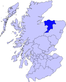
| Council area | Moray |
| Country | Scotland |
| Sovereign state | United Kingdom |
| Post town | ABERLOUR |
| Postcode district | AB38 9xx |
| Dialling code | 01340 |
| Police | Scottish |
| Fire | Scottish |
| Ambulance | Scottish |
| EU Parliament | Scotland |
| UK Parliament | Moray |
| Scottish Parliament | Moray |
Coordinates: 57°28′26″N 3°13′01″W / 57.474°N 3.217°W
Aberlour (Scottish Gaelic: Obar Lobhair[1]), is the name of a town in Moray, Scotland, 12 miles (20 km) south of Elgin on the road to Grantown. A burn (stream), the Lour burn is a tributary of the River Spey, and the surrounding parish, are both named Aberlour, but the name is most commonly used in reference to the village which straddles the stream and flanks the Spey – although the full name of the village is Charlestown of Aberlour.
History
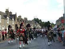
A site noted as Abirlaur is shown in this location on maps in Joan Blaeu's Atlas of Scotland, from 1654.[2][3] The current village, Charlestown of Aberlour, was "founded by Mr. Charles Grant of Elchies in 1812 - with the name of Charlestown of Aberlour after his son Charles."[4] It is commonly referred to simply as Aberlour. A grant of land from Charles Grant senior feued 100 plots along the south bank of the river and saw the start of the High Street (formerly Main Street) and parish church. The three locations are close enough in definition, for there to be little distinction between them. The town was granted its feu charter in 1814 and began to operate its own markets. Whisky was a major industry even then and once the 1823 licensing act was passed and a longer warehousing process introduced it began to take on the more mature characteristics that we are familiar with today.[5]
According to the 1846 A Topographical Dictionary of Scotland, "This parish, formerly called Skirdustan, signifying, in the Gaelic tongue, 'the division of Dustan,' its tutelary saint, derived its present name from its situation at the mouth of a noisy burn, which discharges itself into the river Spey."[6]
Aberlour once was the site of an orphanage which was founded by a minister called Charles Jupp. It is said by many who were brought up in the orphanage, that Canon Jupp 'walked' the buildings on 30 November. His tomb lies in St Margaret's Episcopal Church which was the church used by the children of the orphanage. The orphanage was split into two separate units - one for the girls and the other for the boys. Between the two buildings was the school where the children were taught. Aberlour Child Care Trust is now one of Scotland's main children's charities with services throughout Scotland.[7]
Aberlour also is the place where the famous Walkers[8] shortbread is made. Walkers own the woods behind the factory - Fisherton woods. Until 2004, Aberlour was the site of Aberlour House prep school for Gordonstoun. Aberlour Golf Club (now defunct) first appeared in 1905 and continued until the late 1930s.[9]
Thomas Telford, the renowned civil engineer designed Craigellachie Bridge spanning the River Spey about 2 miles (3 km) to the north of the town. It was built after the Great Spate in the 19th century destroyed an earlier bridge. Craigellachie Bridge is now open only to foot and cycle traffic. A new bridge has superseded it.
Alexander Cameron Sim, a pharmacist who introduced lemonade (locally called ramune) to Japan, was born in the town. The area was once served by Aberlour railway station, but this closed as a result of the Beeching Axe.
See also
References
- ↑ "Rannsaich an Stòr-dàta Briathrachais Gàidhlig" (in Scottish Gaelic). Smo.uhi.ac.uk. 2010-11-10. Retrieved 2011-12-11.
- ↑ Archived 24 March 2007 at the Wayback Machine.
- ↑ "Maps of Scotland - National Library of Scotland". Nls.uk. Retrieved 2011-12-11.
- ↑ "The history of Aberlour as seen by Dr B M Sellar". Speyside.moray.org. Archived from the original on 4 February 2012. Retrieved 2011-12-11.
- ↑ Dyer, Fraser (2012). Old Aberlour. Catrine, Ayrshire: Stenlake Publishing. p. 3. ISBN 9781840336108.
- ↑ "Aberdour - Anderston | A Topographical Dictionary of Scotland (pp. 23-45)". British-history.ac.uk. 2003-06-22. Retrieved 2011-12-11.
- ↑ "Scotland's Children's Charity. Aberlour supports children, young people and families throughout Scotland". Aberlour. 2011-04-08. Retrieved 2011-12-11.
- ↑ "Home". Walkersshortbread.com. Retrieved 2011-12-11.
- ↑ "Aberlour Golf Club, Moray", "Golf’s Missing Links".
External links
| Wikimedia Commons has media related to Aberlour. |
Places in Moray | ||
|---|---|---|
|  | |