Abansky District
| Abansky District Абанский район (Russian) | |
|---|---|
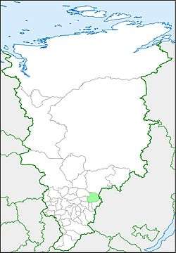 Location of Abansky District in Krasnoyarsk Krai | |
| Coordinates: 56°N 96°E / 56°N 96°ECoordinates: 56°N 96°E / 56°N 96°E | |
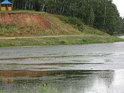 The Aban River near the settlement of Aban in Abansky District | |
 | |
|
| |
| Location | |
| Country | Russia |
| Federal subject | Krasnoyarsk Krai[1] |
| Administrative structure (as of December 2011) | |
| Administrative center | settlement of Aban[1] |
| Administrative divisions:[1] | |
| selsoviet | 16 |
| Inhabited localities:[1] | |
| Rural localities | 64 |
| Municipal structure (as of December 2008) | |
| Municipally incorporated as | Abansky Municipal District[2] |
| Municipal divisions:[2] | |
| Urban settlements | 0 |
| Rural settlements | 16 |
| Local government: | |
| Head[3] | Mikhail I. Krivitsky[4] |
| Representative body | Abansky District Council of Deputies[3] |
| Statistics | |
| Area (municipal district) | 9,512 km2 (3,673 sq mi)[5] |
| Population (2010 Census) | 22,577 inhabitants[6] |
| • Urban | 0% |
| • Rural | 100% |
| Density | 2.37/km2 (6.1/sq mi)[7] |
| Time zone | KRAT (UTC+07:00)[8] |
| Established | April 4, 1924[5] |
| Official website | |
| Abansky District on WikiCommons | |
Abansky District (Russian: А́банский райо́н) is an administrative[1] and municipal[2] district (raion), one of the forty-three in Krasnoyarsk Krai, Russia. It is located in the southeast of the krai and borders with Boguchansky District in the north, Irkutsk Oblast in the east, Nizhneingashsky District in the southeast, Ilansky District in the south, Kansky District in the southwest, Dzerzhinsky District in the west, and with Taseyevsky District in the west and northwest. The area of the district is 9,512 square kilometers (3,673 sq mi).[5] Its administrative center is the rural locality (a settlement) of Aban.[1] Population: 22,577 (2010 Census);[6] 26,783 (2002 Census);[9] 32,501 (1989 Census).[10]
Geography
The district lies between the forest steppe and taiga zones. It stretches for 124 kilometers (77 mi) from west to east and for 120 kilometers (75 mi) from north to south.
History
The district was founded on April 4, 1924.[5]
Abansky District is characterized by a diversity of its population. Many people voluntarily migrated to this area, but some were exiled here as well. During the 18th–19th centuries, the region was a common destination for exiled insurgents and revolutionaries, including Poles and the Decembrists. Most, however, migrated here voluntarily in the beginning of the 20th century, after the revolutionary events of 1905 and as a result of the agrarian reforms by Pyotr Stolypin.
Migrants typically traveled by rail and arrived in big groups to Kansk. From there, they transported by horses to Aban. The majority of the farms and villages in the area appeared in the first two or three decades of the 20th century. Various ethnic groups tended to stick together for the reasons of common language, traditions, customs, and religious beliefs. This led to the establishment of villages populated mostly by the members of a single ethnic group; for example, Sterlitamak was predominantly Tatar, Vostok was a village of the Chuvash people, while Vorobyovka was populated by the Mordvins.
The second wave of migrants rushed in during the late 1920s, as the area was subject to collectivization on a lesser scale than other regions of the country. New migrants usually moved with their fellow countrymen who had already been well-settled in the area and were able to provide the newcomers with support and assistance. The aspiration to "stick together" further strengthened and unified already tight ethnic communities. Even after settling in, people continued to speak their native language and maintained their customs and traditions, passing them on to the new generations. However, they also had to master Russian, as it was the language of communication between various ethnic groups and the language of the government.
Various ethnic communities lived in peace and friendship, respecting each other's customs and sharing the best practices and experiences. Eventually, over time, the cultures blended together, creating a group which is now described by the term "Siberians".
After World War II, many people exiled here started families; many remained to live and work in the district.
In the 1960s, Aban became a destination for people exiled from the big cities under the "Decree of 1961"—people were sent here for their religious beliefs, for drunkenness, and for parasitism. As a result, the social composition of the population changed significantly. While the 1930s–1940s saw an influx of educated people and intellectuals sent here for political reasons, a significant portion of the exiles of the 1960s consisted of the people genuinely unwilling to work and "re-educated" by means of forcing them to work on forest plots. Five commandants were assigned to Abansky District to oversee the forced labor.
The villages of Machino, Tagashi, Noshino, and Beryozovka housed Germans who were deported here after the end of World War II. The deported Germans were required to register with the local commandant twice a month and were prohibited from leaving their assigned residences. Many Germans were separated from their families, and only in the 1980s they were allowed to leave.
Economy

Agriculture and forestry, at 55.6%, comprise the largest share of the district's economy, followed by the wholesale and retail trade and auto maintenance (18%).
Abansky District is one of the top agricultural districts in the krai in terms of production volume. The district specializes in grain crops and their processing. Animal husbandry specializes in pig- and cattle-breeding.
The district is rich in timber and coal reserves.[11][12]
Education
Fifty-seven educational facilities are located in the district:
- 11 pre-school facilities
- 43 secondary schools
- 1 inter-school educational-industrial complex
- 2 continuous education establishments for children
Thirty-four per cent of children between ages one and eleven are covered by the pre-school educational system.
Public health services
There are three hospitals with the total of 211 beds in the district, in addition to 4 clinics. There are on average 14.3 doctors per 10,000 people and 7.7 medical workers per 1,000 people.
Medicinal Lake Plakhino (Borovoye) is located in the district.[13]
References
Notes
- 1 2 3 4 5 6 Law #10-4765
- 1 2 3 Law #13-2755
- 1 2 Charter, Article 6.1
- ↑ Official website of Abansky District. Head of the district (Russian)
- 1 2 3 4 Official website of Krasnoyarsk Krai. Information about Abansky Municipal District (Russian)
- 1 2 Russian Federal State Statistics Service (2011). "Всероссийская перепись населения 2010 года. Том 1" [2010 All-Russian Population Census, vol. 1]. Всероссийская перепись населения 2010 года (2010 All-Russia Population Census) (in Russian). Federal State Statistics Service. Retrieved June 29, 2012.
- ↑ The value of density was calculated automatically by dividing the 2010 Census population by the area specified in the infobox. Please note that this value is only approximate as the area specified in the infobox does not necessarily correspond to the area of the entity proper or is reported for the same year as the population.
- ↑ Правительство Российской Федерации. Федеральный закон №107-ФЗ от 3 июня 2011 г. «Об исчислении времени», в ред. Федерального закона №271-ФЗ от 03 июля 2016 г. «О внесении изменений в Федеральный закон "Об исчислении времени"». Вступил в силу по истечении шестидесяти дней после дня официального опубликования (6 августа 2011 г.). Опубликован: "Российская газета", №120, 6 июня 2011 г. (Government of the Russian Federation. Federal Law #107-FZ of June 31, 2011 On Calculating Time, as amended by the Federal Law #271-FZ of July 03, 2016 On Amending Federal Law "On Calculating Time". Effective as of after sixty days following the day of the official publication.).
- ↑ Russian Federal State Statistics Service (May 21, 2004). "Численность населения России, субъектов Российской Федерации в составе федеральных округов, районов, городских поселений, сельских населённых пунктов – районных центров и сельских населённых пунктов с населением 3 тысячи и более человек" [Population of Russia, Its Federal Districts, Federal Subjects, Districts, Urban Localities, Rural Localities—Administrative Centers, and Rural Localities with Population of Over 3,000] (XLS). Всероссийская перепись населения 2002 года [All-Russia Population Census of 2002] (in Russian). Retrieved August 9, 2014.
- ↑ Demoscope Weekly (1989). "Всесоюзная перепись населения 1989 г. Численность наличного населения союзных и автономных республик, автономных областей и округов, краёв, областей, районов, городских поселений и сёл-райцентров" [All Union Population Census of 1989: Present Population of Union and Autonomous Republics, Autonomous Oblasts and Okrugs, Krais, Oblasts, Districts, Urban Settlements, and Villages Serving as District Administrative Centers]. Всесоюзная перепись населения 1989 года [All-Union Population Census of 1989] (in Russian). Институт демографии Национального исследовательского университета: Высшая школа экономики [Institute of Demography at the National Research University: Higher School of Economics]. Retrieved August 9, 2014.
- ↑ Krasnoyarsk Krai Coal (Russian)
- ↑ Geography (Coal)(Russian)
- ↑ Совет Администрации Красноярского края. Постановление №173-п от 30 июня 2004 г. «Об установлении границ и режима округа горно-санитарной охраны лечебно-оздоровительной местности краевого значения "Озеро Плахино" (Боровое) Абанского района». Вступил в силу в день, следующий за днём официального опубликования. Опубликован: "Ведомости высших органов государственной власти Красноярского края", №17, 14 июля 2004 г.
Sources
- Законодательное собрание Красноярского края. Закон №10-4765 от 10 июня 2010 г. «О перечне административно-территориальных единиц и территориальных единиц Красноярского края», в ред. Закона №7-3007 от 16 декабря 2014 г. «Об изменении административно-территориального устройства Большеулуйского района и о внесении изменений в Закон края "О перечне административно-территориальных единиц и территориальных единиц Красноярского края"». Вступил в силу 1 июля 2010 г. Опубликован: "Ведомости высших органов государственной власти Красноярского края", №33(404), 5 июля 2010 г. (Legislative Assembly of Krasnoyarsk Krai. Law #10-4765 of June 10, 2010 On the Registry of the Administrative-Territorial Units and the Territorial Units of Krasnoyarsk Krai, as amended by the Law #7-3007 of December 16, 2014 On Changing the Administrative-Territorial Structure of Bolsheuluysky District and on Amending the Krai Law "On the Registry of the Administrative-Territorial Units and the Territorial Units of Krasnoyarsk Krai". Effective as of July 1, 2010.).
- Законодательное собрание Красноярского края. Закон №13-2755 от 17 декабря 2004 г. «Об установлении границ и наделении соответствующим статусом муниципального образования Абанский район и находящихся в его границах иных муниципальных образований», в ред. Закона №7-2509 от 4 декабря 2008 г «О внесении изменений в закон края "Об установлении границ и наделении соответствующим статусом муниципального образования Абанский район и находящихся в его границах иных муниципальных образований"». Вступил в силу через десять дней после официального опубликования. Опубликован: "Ведомости высших органов государственной власти Красноярского края", №1, 10 января 2005 г. (Legislative Assembly of Krasnoyarsk Krai. Law #13-2755 of December 17, 2004 On Establishing the Borders and Granting an Appropriate Status to the Municipal Formation of Abansky District and to Other Municipal Formations Within Its Borders, as amended by the Law #7-2509 of December 4, 2008 On Amending the Krai Law "On Establishing the Borders and Granting an Appropriate Status to the Municipal Formation of Abansky District and to Other Municipal Formations Within Its Borders". Effective as of ten days after the official publication.).
- Абанский районный Совет. Решение №8-31 от 20 февраля 1998 г. «Устав Абанского района Красноярского края», в ред. Решения №17-147Р от 19 декабря 2011 г «О внесении изменений и дополнений в Устав Абанского района Красноярского края». Вступил в силу в день, следующий за днём официального опубликования, осуществляемого при наличии государственной регистрации. Опубликован: "Красное Знамя", №41–44 (извлечение), 13 марта 2009 г. (Abansky District Council. Decision #8-31 of February 20, 1998 Charter of Abansky District of Krasnoyarsk Krai, as amended by the Decision #17-147R of December 19, 2011 On Amending and Supplementing the Charter of Abansky District of Krasnoyarsk Krai. Effective as of the day following the day of the official publication, providing the state registration has been completed.).