Aam Khas Bagh
| Aam Khas Bagh | |
|---|---|
|
Aam Khas Bag, Sirhind, Fatehgarh Sahib district, Punjab, India | |
| Type | Mughal garden |
| Location | Fatehgarh Sahib district, Punjab |
| Opened | Open to Public |
| Owned by | Archaeological Survey of India |
| Status | Under Repair, |
Aam Khas Bagh, today is actually remains of a highway-inn constructed for the use of royalty as well as common people (as its name denotes). This Royal inn was initially built by Babur extended and almost rebuilt by Mughal Emperor Shah Jahan along the Mughal military road between Delhi and Lahore, and The Royal couple used to stay here in the old building complex, while going to and coming back from Lahore.
Aam Khas Bagh complex
The complex was famous for a perfect air-conditioning system called Sarad Khana. The Sheesh Mahal of the Daulat-Khana-e-Khas, the hamam and the tank had unique methods of heating water. The palace compound also had a set of fountains. Water for the fountains was drawn from a huge well nearby and circulated through underground conduits. A beautiful garden and the Nursery is being maintained.It is a Mugal type Garden.
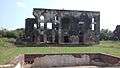
The old complex, which has archaeological value, is being maintained by the Archaeological Survey of India.[1] The area was maintained till a few years ago. Buildings in worst condition include Daulat Khana Khas, Sard Khana and Shahi Hamaam. Lack of upkeep has ruined these buildings.[2]
Monuments
The following monuments are situated in the vicinity of Aam Khas Bagh:[3]
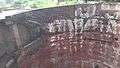
- Sard Khana - This monument was built by Emperor Jahangir. This is an air conditioned chamber of that time. The water was pulled out through large pulleys from the adjoining well and was passed through water channels running through the walls of this building and was used for fountains and waterfalls.
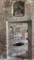
- Sheesh Mahal - This beautiful building was known as Daulat-Khana-E-Khas and was also called Sheesh Mahal. This was built by the orders of Emperor Jahangir. There have been some subsequent alterations to the original building. The domes of this monument were decorated with glazed tiles, some of which are still visible today.
- Hamam - This monument was constructed by the orders of Emperor Jahangir. In this, water was taken through underground terracotta channels and a unique method of heating the water was adopted.
- Tank - This tank was got prepared by orders of Emperor Jahangir. There was a Mehtabi-Chabutra in the centre which has fallen down. On the east and west sides of this tank quarters for Mughal Employees were built.
- Daulat Khana-E-Khas- This double storeyed monument was got built by Mughal Emperor Shah Jahan as his private residence. This must have been the most beautiful building of those time. All the rooms and main walls of this building were decorated with designs. The central hall measured 18 x 14 and eastern walls were having two tall minarets. On the northern side there were many tanks and fountains which added to the grandeur of this building.
Light & Sound show
During the famous Shaheedi Jor Mela at Fatehgarh Sahib, the light and sound programme[4] regarding the history of Sirhind and the martyrdom of younger sons of Guru Gobind Singh in the form of Play - Sirhind Di Deewar[5] is shown to the visitors at night in the Aam Khas Bagh.[6]
Gallery
-

Main Entry Gate of Aam Khas Bagh
-

Entrance of Aam khas Bag, Sirhind, Fatehgarh Sahib district, Punjab, India
-

Aam khas Bag, Sirhind, Fatehgarh Sahib district, Punjab, India , North West side
-

Aam khas Bag, Sirhind, Fatehgarh Sahib district, Punjab, India , Entrence
-

Aam khas Bag, Sirhind, Fatehgarh Sahib district, Punjab, India , Sarad Khana
-

Aam khas Bag, Sirhind, Fatehgarh Sahib district, Punjab, India , view from hight
-

ruins of Daulat Khana-E-Khas
-

Visitor's board in dilapidated condition
-

Sarai Wing ruins
-

Main Water Tank Aam Khas Bhag Fatehgarh Sahib
-

Hamam External Water Channel
-
Hamam internal view
-

Hamam internal underground water tank
-

View of well from saradkhana
-

Sardkhana adjoining water channel
-

Aam Khas Bagh, Sirhind Wells Near Saradkhana ways adjoining well
-
Aam Khas Bagh, Sirhind Wells Near Saradkhana 1
-

Aam Khas Bagh, Sirhind Wells Near Saradkhana
-

Aam Khas Bagh, Sirhind Wells Near Saradkhana with Pullies to lift water
-

Aam Khas Bagh Sirhind Daulat Khana-Ekhas internal ruins
-

Aam Khas Bagh Sirhind Daulat Khana-Ekhas Inside
-
Aam Khas Bagh Sirhind Daulat Khana-Ekhas
-

Aam Khas Bagh, Fatehgarh Sahib
-

Water Channels in Aam Bagh Naugharana
-

Water Channels in Aam Bagh in front of Sardkhana 2
See also
References
- ↑ Aam Khas Bagh, Old Complex
- ↑ Present condition of the internal structure-Source-Tribune India
- ↑ Monuments situated in the vicinity of the Aam Khas Bagh
- ↑ Light & Sound program
- ↑ Sirhind Di Deewar
- ↑ "Archived copy". Archived from the original on 2009-04-09. Retrieved 2010-01-10. Other Places
Coordinates: 30°38′11″N 76°23′50″E / 30.636347°N 76.397156°E