Arctic National Wildlife Refuge
| Arctic National Wildlife Refuge | |
|---|---|
|
IUCN category IV (habitat/species management area) | |
|
Refuge during summer | |
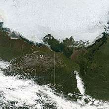
 Location in northern Alaska | |
| Location | North Slope Borough and Yukon-Koyukuk Census Area, Alaska, United States |
| Nearest city | Barrow, Alaska pop. 3,982 |
| Coordinates | 68°45′N 143°30′W / 68.750°N 143.500°WCoordinates: 68°45′N 143°30′W / 68.750°N 143.500°W |
| Area | 19,286,722 acres (78,051 km2) |
| Established | 1960 |
| Governing body | U.S. Fish and Wildlife Service |
| Website | Arctic National NWR |

The Arctic National Wildlife Refuge (ANWR or Arctic Refuge) is a national wildlife refuge in northeastern Alaska, United States. It consists of 19,286,722 acres (78,050.59 km2) in the Alaska North Slope region.[1] It is the largest National Wildlife Refuge in the country, slightly larger than the Yukon Delta National Wildlife Refuge. The refuge is administered from offices in Fairbanks.
Just across the border in Yukon, Canada, are two Canadian National Parks, Ivvavik and Vuntut.
History
The move to protect this corner of Alaska began in the early 1950s, with an article published in the journal of the Sierra Club by then National Park Service planner George Collins and biologist Lowell Sumner entitled "Northeast Alaska: The Last Great Wilderness" in 1953.[2] Collins and Sumner then recruited Wilderness Society President Olaus Murie and his wife Margaret Murie into an effort to permanently protect the area. In 1956, Olaus and Mardy Murie led an expedition to the Brooks Range in northeast Alaska, where they dedicated an entire summer to studying the land and wildlife ecosystems of the Upper Sheenjek Valley.[3] The conclusion resulting from these studies was an ever deeper sense of the importance of preserving the area intact, a determination that would play an instrumental part in the decision to designate the area as Wilderness in 1960. As Olaus would later say in a 1963 speech to a meeting of the Wildlife Management Association of New Mexico State University, "On our trips to the Arctic Wildlife Range we saw clearly that it was not a place for mass recreation... It takes a lot of territory to keep this alive, a living wilderness, for scientific observation and for esthetic inspiration. The Far North is a fragile place." [4]
The region first became a federal protected area in 1960 by order of Fred Andrew Seaton, Secretary of the Interior under U.S. President Dwight D. Eisenhower. In 1980, Congress passed the Alaska National Interest Lands Conservation Act.
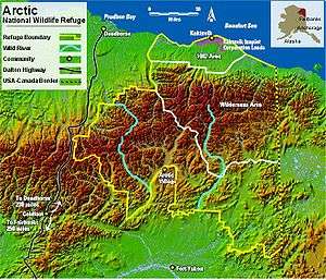
Eight million acres (32,000 km2) of the refuge, the Mollie Beattie Wilderness, are designated as wilderness area.[5] The expansion of the refuge in 1980 designated 1.5 million acres (6,100 km2) of the coastal plain as the 1002 area and mandated studies of the natural resources of this area, especially petroleum. Congressional authorization is required before oil drilling may proceed in this area. The remaining 10.1 million acres (40,900 km2) of the refuge are designated as "minimal management," a category intended to maintain existing natural conditions and resource values. These areas are suitable for wilderness designation, although there are presently no proposals to designate them as wilderness.
There are currently no roads within or leading into the refuge, however there are a few scattered Native settlements within. On the northern edge of the refuge is the Inupiat village of Kaktovik (population 258)[6] and on the southern boundary the Gwich'in settlement of Arctic Village (population 152).[6] A popular wilderness route and historic passage exists between the two villages, traversing the refuge and all its ecosystems from boreal, interior forest to Arctic Ocean coast. Generally, visitors gain access to the land by aircraft, but it is also possible to reach the refuge by boat or by walking (the Dalton Highway passes near the western edge of the refuge). In the United States, the geographic location most remote from human trails, roads, or settlements is found here, at the headwaters of the Sheenjek River.
Geography
The refuge supports a greater variety of plant and animal life than any other protected area in the Arctic Circle. A continuum of six different ecozones spans about 200 miles (300 km) north to south.
Along the northern coast of the refuge, the barrier islands, coastal lagoons, salt marshes, and river deltas of the Arctic coastal tundra provide habitat for migratory waterbirds including sea ducks, geese, swans, and shorebirds. Fish such as dolly varden and Arctic cisco are found in nearshore waters. Coastal lands and sea ice are used by caribou seeking relief from biting insects during summer, and by polar bears hunting seals and giving birth in snow dens during winter.
The Arctic coastal plain stretches southward from the coast to the foothills of the Brooks Range. This area of rolling hills, small lakes, and north-flowing, braided rivers is dominated by tundra vegetation consisting of low shrubs, sedges, and mosses. Caribou travel to the coastal plain during June and July to give birth and raise their young. Migratory birds and insects flourish here during the brief Arctic summer. Tens of thousands of snow geese stop here during September to feed before migrating south, and musk oxen live here year-round.
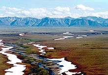
South of the coastal plain, the mountains of the eastern Brooks Range rise to over 9000 feet (3,000 m). This northernmost extension of the Rocky Mountains marks the continental divide, with north-flowing rivers emptying into the Arctic Ocean and south-flowing rivers joining the great Yukon River. The rugged mountains of the Brooks Range are incised by deep river valleys creating a range of elevations and aspects that support a variety of low tundra vegetation, dense shrubs, rare groves of poplar trees on the north side and spruce on the south. During summer, peregrine falcons, gyrfalcons, and golden eagles build nests on cliffs. Harlequin ducks and red-breasted mergansers are seen on swift-flowing rivers. Dall sheep and wolves are active all year, while grizzly bears and Arctic ground squirrels are frequently seen during summer but hibernate in winter.
.jpg)
The southern portion of the Arctic Refuge is within the Interior Alaska-Yukon lowland taiga (boreal forest) ecoregion. Beginning as predominantly treeless tundra with scattered islands of black and white spruce trees, the forest becomes progressively denser as the foothills yield to the expansive flats north of the Yukon River. Frequent forest fires ignited by lightning result in a complex mosaic of birch, aspen, and spruce forests of various ages. Wetlands and south-flowing rivers create openings in the forest canopy. Neotropical migratory birds breed here in spring and summer, attracted by plentiful food and the variety of habitats. Caribou travel here from farther north to spend the winter. Year-round residents of the boreal forest include Alaskan moose, Canadian lynxes, martens, wolverines, black bears, grizzly bears, and wolves.
Each year, thousands of waterfowl and other birds nest and reproduce in areas surrounding Prudhoe Bay and Kuparuk fields and a healthy and increasing caribou herd migrates through these areas to calve and seek respite from annoying pests.
Drilling
 | |
|
|
The questions of whether to drill for oil in the ANWR has been an ongoing political controversy in the United States since 1977.[8] The controversy surrounds drilling for oil in a 1,500,000 acres (6,100 km2) subsection on the coastal plain, known as the "1002 area".[9] Much of the debate over whether to drill in the 1002 area of ANWR rests on the amount of economically recoverable oil, as it relates to world oil markets, weighed against the potential harm oil exploration might have upon the natural wildlife, in particular the calving ground of the Porcupine caribou.[10]
Porcupine caribou herd
The area for possible future oil drilling on the coastal plains of the Arctic National Wildlife Refuge, encompasses much of the Porcupine caribou calving grounds. Migratory caribou herds are named after their birthing grounds, in this case the Porcupine River, which runs through a large part of the range of the Porcupine herd.[11][12] In 2001, some biologists feared development in the Refuge would "push caribou into the foothills, where calves would be more prone to predation."[10] Though numbers fluctuate, there were approximately 169,000 animals in the herd in 2010.[11][12] Their 1,500 miles (2,400 km)-a-year land migration between their winter range in the boreal forests of Alaska and northwest Canada over the mountains to the coastal plain and their calving grounds on the Beaufort Sea coastal plain,[13] is the longest of any land mammal on earth.
In 2001, proponents of the development of the oil fields at Prudhoe Bay and Kuparuk, which would be approximately 60 miles (97 km) west of the Refuge, argued that Central Arctic caribou herd, had increased its numbers "in spite of several hundred miles of gravel roads and more than a thousand miles of elevated pipe." However, the Central Arctic herd is much smaller than the Porcupine herd, and has an area that is much larger.[10] By 2008 the Central Arctic caribou herd had approximately 67,000 animals.[12]
See also
- Alaska Wilderness League
- Arctic Refuge drilling controversy
- Jonathon Solomon
- National Petroleum Reserve–Alaska
- Natural resources of the Arctic
- Arctic policy of the United States
References
- ↑ USFWS Annual Lands Report, 30 September 2009
- ↑ Kaye, Roger. "The Arctic National Wildlife Refuge: An Exploration of the Meanings Embodied in America's Last Great Wilderness" (PDF). Volume 2 (15). USDA Forest Service Proceedings. Retrieved 16 July 2014.
- ↑ Krear, PhD, Robert (July 2000). "The Muries Made the Difference". The Muries Voices for Wilderness & Wildlife: 19–20.
- ↑ Murie, Olaus. "Look Ye Also While Life Lasts". The Muries: Voices for Wilderness and Wildlife.
- ↑ Wilderness Institute, University of Montana (2011). "Mollie Beattie Wilderness". Wilderness.net. Retrieved 29 November 2011.
- 1 2 http://factfinder.census.gov/home/saff/main.html?_lang=en
- ↑ "President Obama Calls on Congress to Protect Arctic Refuge as Wilderness". The White House. January 25, 2015. Retrieved January 26, 2015.
- ↑ Shogren, Elizabeth. "For 30 Years, a Political Battle Over Oil and ANWR." All Things Considered. NPR. 10 Nov. 2005.
- ↑ "Potential Oil Production from the Coastal Plain of the Arctic National Wildlife Refuge: Updated Assessment". US DOE. Archived from the original on 3 April 2009. Retrieved 2009-03-14.
- 1 2 3 Mitchell, John. "Oil Field or Sanctuary?" National Geographic 1 Aug. 2001.
- 1 2 Campbell, Cora (2 March 2011), Porcupine Caribou Herd shows growth, Press release (99811), Juneau, Alaska: Alaska Department of Fish and Game
- 1 2 3 Kolpashikov, L.; Makhailov, V.; Russell, D., "The role of harvest, predators and socio-political environment in the dynamics of the Taimyr wild reindeer herd with some lessons for North America", Ecology and Society
- ↑ Mitchell, John (1 August 2001), Oil Field or Sanctuary?, National Geographic, retrieved 15 January 2014
External links
| Wikimedia Commons has media related to Arctic National Wildlife Refuge. |
- Official ANWR website
- Congressional Research Service (CRS) Reports regarding the Arctic National Wildlife Refuge
- An article about the land and the people of Arctic Wildlife Refuge
- Text of Wilderness Act of 1964