A72 road
| |
|---|---|
|
Click map to enlarge | |
| Route information | |
| Length: | 63 mi (101 km) |
| Major junctions | |
| West end: |
Hamilton 55°46′40″N 4°03′12″W / 55.7778°N 4.0532°W |
|
[[Image:Motorway Left.svg|[ |x30px|link=]] | |
| East end: |
Galashiels 55°37′08″N 2°48′44″W / 55.6189°N 2.8121°W |
| Location | |
| Primary destinations: | Hamilton, Lanark, Peebles, Galashiels |
| Road network | |


The A72 is a major route in Scotland connecting Hamilton in South Lanarkshire, with Galashiels in the Scottish Borders.
It travels for over 60 miles in a South-Easterly direction, along the Clyde and Tweed valleys, passing the towns of Larkhall, Lanark, Biggar and Peebles.
Route
Hamilton to Lanark
Starting at the junction with the A724, the road parallels the M74, following the original A74 (now B7078) before descending into the densely forested Clyde Valley as it skirts around the town of Larkhall. The road follows the meanders of the River Clyde, with some tight bends, sheer drops and adverse cambers. This section of the road passes through some picturesque villages before sharply climbing the edge of the Clyde Valley to meet the A73 at a very busy forked junction just north of Lanark.
Lanark to Symington
This section of the road follows the course of the A73, through the town of Lanark, over Hyndford Bridge and forks left from the A73 just before Symington, again becoming the A72.
Symington to Causewayend
Leaving the A73 just north-west of Symington, the road follows its own course for a short distance, before meeting the main A702, Edinburgh to Abington, South Lanarkshire road. This short section of road is narrow and often congested as it passes through the small village of Symington.
Causewayend to Cambuswallace
This section of the road follows the course of the A702 for approximately 3 miles through the town of Biggar. The main square in the centre of Biggar was previously a large market place, with slightly unruly traffic conditions. But following an increase in traffic along this route it has been extensively re-developed, to allow for a more distinct and clear flow of traffic, with parking and a tree-lined side avenue for local access.
Cambuswallace to Kaimrig End
Just north of Biggar, the road re-gains its own route. Passing over some regularly flooded moorland, it enters the picturesque village of Skirling before ascending onto some higher moorland. This section of road is notorious for accidents due to its high elevation, poor weather and winding route.
Kaimrig End to Blyth Bridge
This is the last section of A72, where it is the secondary route on another primary road. It shares this 6 mile section with the A701. Just south of Blyth Bridge, it meets with the A721 which connects the western Scottish Borders towns of Peebles and Galashiels with the M8 at Newhouse. Less than a mile after this junction, it leaves the course of the A701. This junction of the A72 and A701 at Blyth Bridge is very dangerous for travellers heading north as it is a fork junction which approaches the A72 from a higher position and on a very sharp bend.
Blyth Bridge to Galashiels
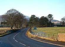
From here, the road follows its own course for the next 25 miles. It ascends a high plateau on a very narrow and winding, but picturesque section, before descending into the valley of the River Tweed at Stobo. It will almost parallel the course of the River Tweed for the remainder of its journey south to Galashiels.
It passes through the pretty market town of Peebles and then on through Innerleithen and Walkerburn towards Galashiels. It comes to an end at a junction with the A7, which leads on to the Galashiels Ring Road.
A roads in Zone 7 of the Great Britain road numbering scheme | ||
|---|---|---|
Coordinates: 55°36′17″N 3°35′32″W / 55.6048°N 3.5922°W