46th parallel south

46°
46th parallel south
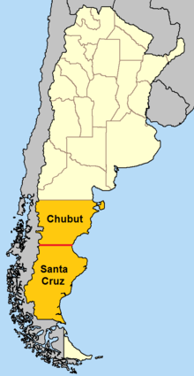
In Argentina, the 46th parallel south defines the border between Chubut Province and Santa Cruz Province.
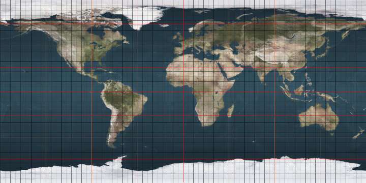
The 46th parallel south is a circle of latitude that is 46 degrees south of the Earth's equatorial plane. It crosses the Atlantic Ocean, the Indian Ocean, Australasia, the Pacific Ocean and South America.
At this latitude the sun is visible for 15 hours, 45 minutes during the December solstice and 8 hours, 38 minutes during the June solstice.
The largest city south of the 46th parallel is Punta Arenas.
Around the world
Starting at the Prime Meridian and heading eastwards, the parallel 46° south passes through:
Co-ordinates Country, territory or sea Notes 46°0′S 0°0′E / 46.000°S 0.000°E Atlantic Ocean 46°0′S 20°0′E / 46.000°S 20.000°E Indian Ocean Passing between Île aux Cochons and Îlots des Apôtres in the Crozet Islands,  French Southern and Antarctic Lands
46°0′S 147°0′E / 46.000°S 147.000°E Pacific Ocean Tasman Sea 46°0′S 166°26′E / 46.000°S 166.433°E  New Zealand
South Island, passing just south of the city of Dunedin 46°0′S 170°15′E / 46.000°S 170.250°E Pacific Ocean 46°0′S 75°2′W / 46.000°S 75.033°W  Chile
Chile46°0′S 71°38′W / 46.000°S 71.633°W  Argentina
The parallel approximately defines the border between Chubut Province and Santa Cruz Province 46°0′S 67°35′W / 46.000°S 67.583°W Atlantic Ocean
See also
|
This article is issued from Wikipedia - version of the 5/3/2016. The text is available under the Creative Commons Attribution/Share Alike but additional terms may apply for the media files.