39th meridian west from Washington
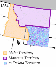
The partition of the Idaho Territory which made the meridian a boundary
The 39th meridian west from Washington is an archaic meridian based on the Washington meridian. The meridian is used as a boundary for two states.
The first and only usage of the meridian as a boundary occurred in 1864. In that year, the Montana Territory was created from Idaho Territory with the meridian serving as its extreme northwestern boundary.[1] Montana became a state in 1889, with Idaho following the next year.[2][3]
References
- ↑ 13 Stat. 85
- ↑ Holmes, Krys (2008). "Chapter 10 - Politics and the Copper Kings, 1889 - 1904". Montana: Stories of the Land (PDF). Helena: Montana Historical Society Press. p. 193.
- ↑ "History". State of Idaho. Retrieved 16 May 2014.
This article is issued from Wikipedia - version of the 9/13/2014. The text is available under the Creative Commons Attribution/Share Alike but additional terms may apply for the media files.