34th meridian west from Washington
The 34th meridian west from Washington is an archaic meridian based on the Washington Meridian and hence 111°2′48.0″ West of Greenwich.[1] The meridian is most notably used as a boundary for four states.
Usage as a boundary
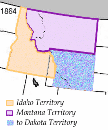
The meridian was first used as a boundary when the Montana Territory was created in 1864. It served as Montana Territory's extreme southwestern boundary.[2] The next usage of the boundary came when the Wyoming Territory was established in 1868, with the meridian as its western boundary.[3] It was also at this time that it became much of the then-Idaho Territory's eastern boundary, as well as the extreme northeastern boundary of the then-Utah Territory. Montana became a state in 1889, with Idaho and Wyoming following the year afterwards.[4][5][6] Utah became a state in 1896.[7]
References
- ↑ Stein, Mark (2008). How the States Got Their Shapes. New York: Smithsonian Books. p. 304. ISBN 978-0-06-143138-8.
- ↑ 13 Stat. 85
- ↑ 15 Stat. 178
- ↑ Holmes, Krys (2008). "Chapter 10 - Politics and the Copper Kings, 1889 - 1904" (PDF). Montana: Stories of the Land. Helena: Montana Historical Society Press. p. 193.
- ↑ "History". State of Idaho. Retrieved 16 May 2014.
- ↑ "Wyoming History". State of Wyoming. 2013. Retrieved 15 May 2014.
- ↑ Ron Rood and Linda Thatcher (2014). "Statehood" (HTML). A Brief History of Utah. Utah History to Go. State of Utah. Retrieved 16 May 2014.