2015–16 North American winter
 Satellite image of the historic blizzard over the Northeast U.S on January 23, 2016. | |
| Astronomical winter | December 21 – March 20 |
|---|---|
| Meteorological winter | December 1 – February 29 |
The 2015–16 North American winter refers to winter in North America as it occurred across the North American continent from late 2015 through early 2016. While there is no well-agreed-upon date used to indicate the start of winter in the Northern Hemisphere, there are two definitions of winter which may be used. Based on the astronomical definition, winter begins at the winter solstice, which in 2015 occurred late on December 21, and ends at the March equinox, which in 2016 occurred on March 20.[1] Based on the meteorological definition, the first day of winter is December 1 and the last day February 29.[2] Both definitions involve a period of approximately three months, with some variability.
Seasonal forecasts
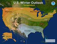

On October 15, 2015, the National Oceanic and Atmospheric Administration's Climate Prediction Center issued its U.S. Winter Outlook. The presence of a strong El Niño event was expected to affect weather and climate patterns by influencing the position of the Pacific jet stream. According to CPC deputy director Mike Halpert at the time of the outlook, "A strong El Niño is in place and should exert a strong influence over our weather this winter" and "While temperature and precipitation impacts associated with El Niño are favored, El Niño is not the only player. Cold-air outbreaks and snow storms will likely occur at times this winter. However, the frequency, number and intensity of these events cannot be predicted on a seasonal timescale." Other oscillations anticipated to have some affect on winter in the United States were the Arctic oscillation and the Madden–Julian oscillation. The precipitation outlook indicated an elevated likelihood of above-average levels precipitation from central and southern California to Texas and Florida and northward to southern parts of New England. Above-average precipitation was also favored in southeastern Alaska, with below-average levels of precipitation favored in central and western Alaska, parts of the Northwestern U.S. and northern Rocky Mountain states, and areas in the vicinity of the Great Lakes and Ohio Valley. The temperature outlook favored below-average temperatures in the southern Plains and Southeastern United States. Above-average temperatures were most favored across the West and the northern half of the contiguous United States and Alaska and Hawaii. The drought outlook anticipated improvement in conditions in central and southern California by the end of January 2016, noting the possibility of additional alleviation of drought conditions in February and March. The outlook favored the removal of drought across large parts of the Southwestern U.S., with additional lessening or elimination of drought conditions likely in the southern Plains. Drought conditions were expected to persist across the Pacific Northwest and northern Rocky Mountains, with development likely in Hawaii and areas in the vicinity of the northern Great Lakes region.[3]
On November 30, 2015, Environment Canada issued its winter outlook for December, January, and February, as part of their monthly climate outlooks. Above-average temperatures were favoured throughout most of Canada, with the exception of northern Quebec and the southern tip of Baffin Island; areas that were considered the most likely to see above normal temperatures included the Lower Mainland of British Columbia, the Maritime provinces, southern Newfoundland, central Quebec and Ontario, and northern Manitoba and Saskatchewan; in those areas, the probability of above-normal temperatures was over 80%. The areas where below-normal temperatures were favoured included extreme northern areas of Quebec and Labrador, along with southern parts of Baffin Island. Above average precipitation was favoured in the Lower Mainland of B.C., New Brunswick, northern Quebec, northern Newfoundland, the Northwest Territories, and western Nunavut. Below-average precipitation was favoured on the south-eastern tip of Baffin Island and a small area just north of Lake Superior.[4]
Seasonal summary

The winter of 2015–16 was quite unusual and historic in terms of winter weather. First, around the end of November near Black Friday, a crippling ice storm hit the Southern and Central Plains with as much as 1.5 inches (38 mm) of ice accumulation in some areas, knocking out power to over 100,000 residents.[5] In December, two winter storms impacted the Great Lakes, with the latter one being a bit farther to the west, both brought roughly a foot of snow in some locations. Normally, in this area, this is not common, but the strong El Niño may have been a contributor to this. Following that, the nation had one of the warmest Decembers on record, with New York City being as warm as 70 °F on Christmas Eve (December 24). A strong tornado outbreak also occurred from December 23–25, which a very similar event had occurred the year before, just weaker.[6] After this system passed, a larger storm complex moved through the same areas impacted by the ice storm from Black Friday 2015. This storm brought blizzard conditions to parts of Texas and New Mexico, with areas reaching up to close to 2 feet of snow in parts of Texas, which is a rare event in that state.[7] For comparison, the last time this has occurred (or near the same areas), was in 2011 during the Groundhog Day blizzard.

The month of January 2016 was variable in its weather patterns. Following the warm trend in December, an early cold snap brought close-to-average temperatures to the East Coast, at the same time a storm complex was moving through the Northeast, and due to the fresh batch of cold air, it was able to produce some snow on the back side of it.[8] At the opposite end of the spectrum, the West Coast was receiving needed rainfall to help during its long-time drought. This brief period of relief ended shortly after. After that, around January 16–17, a potent storm system moved up the East Coast, bringing the first snowfall of the season to areas like Philadelphia and New York City. A few days later, an Alberta clipper moved through the central United States, producing a swath of snow from Illinois to North Carolina. This small system was then proceeded and eclipsed by a crippling and historic blizzard just days later on January 22–23. Cities like Washington D.C, Philadelphia, and New York City were buried with 1–2.5 feet (12–30 in) of snow, breaking numerous records.[9]
In February, the historic weather events continued, as another snowstorm kicked off the month with a swath of snow from Colorado to Michigan. Snow accumulations ranged from 8–14 inches (20–36 cm), along with winds up to 45 mph (72 km/h).[10] After the storm system passed, its cold front transformed into another potent snowstorm for the East Coast, with snowfall amounts up to 8 inches.[11]
From there, another winter storm occurred as a nor'easter, bringing more snow to New England on February 8.[12] Shortly thereafter, the coldest air of the season froze parts of the Northeast on February 14, with temperatures dipping to as low as 0 °F (−18 °C), shattering many record low temperatures.[13] The cold lingered into Presidents Day as another winter storm began to take shape. This set the stage for more snow in the Northeast. Snowfall ranged anywhere from 4–6 inches (10–15 cm) in the Northeast, to 12–18 inches (30–46 cm) in the Appalachians.[14] What was interesting about the weather pattern for this system, was the 24-hour weather difference, for example, at 2:00pm EDT on February 15, New York City reported snow with temperatures in the 30s, and a day later, reported temperatures in the mid-50s and thunderstorms on February 16. The system departed by February 17.
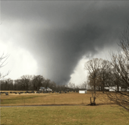
A week later around February 22–24, another winter storm formed and eventually produced the second-largest tornado outbreak ever recorded in February.[15] The storm complex produced as much as 59 confirmed tornadoes, with 4 of them being rated an EF3, including areas which don't normally see tornadoes that strong. The massive system moved out of the United States by February 25.
March was quite extreme. At the start of the month, a quick-moving winter storm produced a swath of 5–8 inches (13–20 cm) across the Midwest.[16] Following this system, on March 3–4, an Alberta clipper quickly moved southeastwards through the same areas affected by the previous winter storm. This storm moved offshore late on March 3, and began undergoing bombogenesis. The cyclone laid down a brief coating of 1–7 inches (2.5–17.8 cm) of snowfall across the Mid-Atlantic states early on March 4.[17]
A few days later, an area of low pressure in the upper levels of the atmosphere dove into Mexico, where it stalled for a few days, and caused some extreme and record-breaking weather events from March 7–10. Parts of the South were inundated with days of heavy rain, with areas receiving more than 18 inches of rain, leading to historic flash flooding.[18] At the same time, record-breaking temperatures pushed into the Northeast, with some areas reaching into the low 80s (which broke the record for earliest 80 degree day on record). The storm system also produced snow in Mexico, which rarely receives it at all.
Around the spring equinox, winter was still not done. A weak nor'easter formed on March 20, and tracked up the East Coast later that day, producing a swath of snow up to 10 inches in some spots.[19] The nor'easter was predicted to be stronger then what was actually observed, but due to computer models, direction of the low pressure, and amount of cold air present made it difficult to precisely time the storm out. The storm then went on to enter the Arctic Ocean where it explosively deepened to a minimum of 949 millibars (28.0 inHg) on March 23. That same day, another winter storm began to produce blizzard conditions in the High Plains, and dropped up to 30 inches (76 cm) of snow in parts of the High Plains and the Great Lakes through March 23–25, along with bringing a significant ice storm to parts of New England, with accumulations of 0.25–0.75 inches (6.4–19.1 mm) of ice in some areas.[20]
After this storm, an area of low pressure then moved ashore on the West Coast early on March 28. Moving eastward, it began to intensify and turn to the northeast and began producing snowfall in and around the areas of Denver by March 29.[21] However, this wasn't as much as a significant snowstorm as the previous one was, as snowfall from this winter storm was relatively less of that from the previous blizzard.[21] The system began to stall for a bit and began drawing moisture from the Gulf of Mexico. In combination, wind shear was unstable in areas in the South, setting up a possible severe thunderstorm threat. Thunderstorms began to fire up late on March 30, with some coalescing into a squall line, and some becoming tornadic supercells. Numerous tornadoes were reported, with some being spotted near the Tulsa airport, which was later rated an EF2.[22] This system slowly moved out by mid-day on April 2.
Even though winter was officially over, it felt like winter somewhat in the Northeast. An unusual cold blast occurred at the beginning of the month, bringing temperatures 10–15 °F (−12 – −9 °C) below average in the afflicted areas.[23] It was cold enough for snow in parts of New England, and as a result, several Alberta clippers began to track their way to the East Coast. The first clipper brought mainly high winds and snow showers to much of the Northeast early on April 3, with mainly high wind warnings being issued.[24] This system moved off rather quickly and immediately began undergoing bombogenesis, with its pressure dropping to 984 millibars (29.1 inHg) by 12 UTC, less than 3 hours after the centre had moved off the coast. It then went to further deepen to a peak of 954 millibars (28.2 inHg) late on April 4. The next clipper system was weaker, but brought a swath of accumulating snow to the southeastern parts of New England. It later moved off late that night.[25] A third clipper system began to edge its way into the Great Lakes on April 6, and brought the risk for wildfires as well. It moved into Canada while transitioning into a storm complex on April 7. A fourth system then moved across nearly the same areas from April 8–9, bringing even more spring snow to the Mid-Atlantic states. This system actually intensified into a small nor'easter on April 9, and brought 1–3 inches (2.5–7.6 cm) of wet snow from the Ohio Valley into the Northeast. It moved off later that night, but brought some more cold air with it. Finally, the cold air retreated out of the region by April 11–12, as warm air began to surge back in.
However, winter made one last comeback during the weekend of April 16–17, as an upper-level low stalled in the West, producing a major snowstorm that affected the High Plains and Rocky Mountains in areas near the Denver metropolitan area, dumping up to 4 feet (48 in) of heavy snow, which led to power outages.[26] The storm also produced record rainfall of up to 20 inches (51 cm), leading to severe flash floods. The system moved slowly eastward, as a developing Omega Block pattern was expected to bring extreme relief to the cold stricken Midwest and East Coast.
Events
Late November ice storm
Around Black Friday 2015, a major ice storm occurred around areas in the Central Plains near and in Oklahoma City, with some areas receiving up to 1.5 inches (3.8 cm) of freezing rain, causing power to be knocked out to thousands.[27] The storm also brought the first arctic blast of cold temperatures of the season. Oddly enough, the moisture for this system also originated from Hurricane Sandra in the East Pacific, which was a late-season tropical cyclone as well as the strongest November hurricane on record.
December warmth
Much of the eastern U.S had its warmest December on record. Nationwide, it was the warmest and wettest December on record.[28] Places as far north as New York City reached 70 °F (21 °C) on Christmas Eve.[29]
In Canada, temperatures in Montreal reached a record breaking 16 °C (61 °F) on Christmas Eve, 20 °C (36 °F) above normal for this time of the year. The previous record had been 8.3 °C (46.9 °F) on December 24, 1957.[30]
Post-Christmas storm complex
Two days after Christmas, a large storm complex with snow, severe weather and heavy rainfall impacted the Southern Plains and southern Rocky Mountains, including all or parts of the states of Colorado, New Mexico, Texas and Oklahoma. The system spawned tornadoes over central and eastern Texas and Oklahoma, while bringing blizzard conditions to the Texas and Oklahoma panhandles, most areas in New Mexico, and southern Colorado. The main area of low pressure moved northeast from the southern Plains to the eastern Great Lakes, while a secondary low pressure system formed east of the Delmarva Peninsula on December 29. After impacting New Mexico and the Texas panhandle with record snowfall, the storm system left a swath of snow and ice accumulation from western Oklahoma to Michigan. On December 29, the storm system brought a mix of snow, sleet and freezing rain to New York State and New England.
On December 26, 2015, it affected parts of the Texas Panhandle and resulted in the formation of tornadoes in the Dallas area, including an EF4 which struck the Garland area that evening.[31][32][33]
On December 27, the same storm left 40 cm (15in.) of snow on the Southern part of the province of Quebec (Canada) with temperatures reaching -30C (-32F) as a daytime high, and -45C (-48F) low. Adding up the windchill brought temperatures below the -45C mark for daytime highs and below -50C for the low.
.jpg)
Late January blizzard
A crippling and historic blizzard occurred from January 22–23 in the Mid-Atlantic states. The storm was given various unofficial names, including Winter Storm Jonas, Blizzard of 2016, and Snowzilla among others. The highest reported snowfall was 40 inches (100 cm) in Glengary, West Virginia. Locations in five states exceeded 30 inches of snow. The storm dropped 18 inches of snow in Washington, D.C., 22 inches in Philadelphia, 26 inches in Baltimore, 30.5 inches in New York City.[34][35][36] States of emergency have been declared in Maryland, North Carolina, Pennsylvania, Tennessee, Virginia, Delaware, New York, and Washington, D.C.[37] The storm also caused coastal flooding in Delaware and New Jersey. Cape May, New Jersey set a record high water level at 8.98 feet, higher than the 8.90 feet seen during Hurricane Sandy.[34] High winds led to blizzard conditions in many areas. Sustained winds of 59 miles per hour (95 km/h) with gust of 72 mph were recorded in Delaware. 70 miles per hour (110 km/h) gusts were also recorded in Massachusetts.[34]
Early February winter storm
A trailing low pressure system to the previous weeks' blizzard had developed offshore California on January 29. The low and accompanying precipitation moved onshore the next day. At the time blizzard conditions were expected. The storm moved eastward into the Great Plains where tremendous snowfall occurred. On February 1, another area of low pressure led to severe weather across the Southeastern United States. Multiple tornadoes were reported in Alabama, Mississippi and Tennessee, including a large EF2 tornado. After the storm had passed, the cold front associated with it stalled over the East Coast late on February 4. A new low pressure developed off North Carolina that night and started to track up the coast. It impacted areas already hit hard by the previous blizzard about two weeks prior, and caused messy travel along Interstate 95 (Northeast). The storm brought a quick but moderate-to-heavy burst of steady snow, with some areas in New England receiving up to 1 foot (0.30 m).
February nor'easter
On February 7, an elongated area of low pressure developed offshore to the west of Florida. While moving inland, it produced a decent dose of rainfall to the Sunshine State as it moved to the northeast. Later the same day, it moved offshore into the Atlantic Ocean and began to undergo bombogenesis, it's pressure dropping from 1,004 millibars (29.6 inHg) at 7 a.m EST February 7 to 979 millibars (28.9 inHg) at 1 a.m EST February 8.[38] As it did so, it also began to transition into a nor'easter, as rainbands began to impact the eastern edges of North Carolina and South Carolina. There was some cold air aloft, allowing for a few areas of wet snow to develop further inland. As the cyclone continued to strengthen, it started to achieve the conditions of a bomb cyclone. Furthermore, the system started to form an eye compared to that of a typical Category 1 hurricane, however this was short-lived and dissolved a few hours later. Snowbands began to impact New England early in the morning of February 8, with some bands reaching up to snowfall rates of an inch per hour, especially near the coast. The outermost bands did not reach New Jersey and New York City, due to the nor'easter being far offshore. The storm continued to deepen for a few more hours before reaching its peak intensity of 976 millibars (28.8 inHg). The system then continued to weaken as it moved northward, before finally merging with another low pressure system on February 10 to the south of it which had also exited from the East Coast.

Mid-February cold wave
During mid-February, bone-chilling temperatures swung across the Northeast United States.[39] On 13 February 2016, Whiteface Mountain underwent a record windchill of -114 degrees Fahrenheit[40] while in Boston, Massachusetts, the temperature dropped to minus 9 degrees Fahrenheit. The windchill descended to minus 36 degrees Fahrenheit, surpassing the previous record by 6 degrees Fahrenheit.[41] The recorded temperatures were the coldest recorded since a very similar cold wave impacted the region exactly a year prior.
President's Day snowstorm
During the middle of February, a potent snowstorm impacted parts of the Ohio Valley, the Appalachians, and the Mid-Atlantic States. Originating from a weak area of low pressure in the Midwest on February 14 (Valentine's Day), it began to track eastwards towards the East Coast. The low began to draw some moisture from the Atlantic Ocean. Due to an arctic airmass of high pressure that had produced record cold temperatures over the Northeast just the day before, snowfall easily broke out in an area stretching from Philadelphia to western Connecticut. The low produced moderate to heavy snow in the Tri-State Area throughout the course of February 15, before weakening and merging with a stronger area of low pressure that was approaching from the south. Snowfall amounts from this portion of the system ranged from 2–5 inches (5.1–12.7 cm), with higher amounts in the mountainous elevations.[42]
The second half of the system formed in the Deep South, as a squall line coalesced during the middle of the day on February 15, as well as supercell thunderstorms. This eventually led to 22 tornadoes being produced, affecting the southern parts of the United States.[43] The storm produced the first EF3 tornado of the year near Century, Florida.[44] The southern part eventually became the dominant low of the winter storm, and it began to track inland up through the Appalachian Mountains. With the arctic air still in place, as warm air over-rode the cold air, an ice storm scenario developed. Freezing rain was in a north-to-south orientation as the system moved up to the Northeast. As heavy rain moved through the Tri-State area, snow developed again on the back of the system which produced snowfall totals of 3–8 inches (7.6–20.3 cm). It then moved out by February 17. In total, the storm knocked out power to thousands.[42]
Late February tornado outbreak
On February 23, a low pressure area developed near the east end of Texas and began to track northeastwards into the Mid-Atlantic States in the early hours of February 24. During this period, it also began to interact with some cold air on the back side of it, producing snow and ice in parts of the Ohio Valley, dumping as much as 17.0 inches (43 cm) of snow.[45] At the same time, ahead of the cold front, severe thunderstorms developed ahead of it, which would eventually lead to the second largest tornado outbreak of the month of February.
Super Tuesday storm system
On Super Tuesday of 2016 (March 1), a winter storm moved quickly through the Upper Midwest, with snow accumulations up to 9 inches (23 cm). It also brought ice from south of Chicago to upper New England. This storm reached all the way up to Quebec City leaving ice rain and a fresh snowpack of roughly 20 cm. The weight of the ice tore power pylons apart and left roughly 700 000 without power for several days in the province of Quebec (Canada). The winter storm also produced some severe weather in the South as well, but nowhere near as significant as the previous outbreak. In the United States, central Michigan and metropolitan Detroit were affected by this storm.
The pressure center of the storm followed afterwards the Southern tip of the Erie and Ontario great lakes, and it intensified in the evening of March 1. The majority of precipitations stayed North of the border though. Hence, Southern Ontario, including the greater Toronto area, Kingston, North Bay and Ottawa received significant snowfall ranging from 10 to 20 cm (4–8 in).
In the early morning, the storm deepened as it became a blizzard. Blizzard warnings were issued from the greater Montreal area to Quebec City, as well as winter storm warnings for other parts of Northern Quebec. While Montreal saw only 9 cm (4 in) of snow (the majority of precipitations fell as ice pellets),[46] central Quebec, Trois-Rivières, Drummondville, Québec City and Rimouski experienced severe whiteout conditions. 30 to 35 cm (12–14 in) of snow fell over Quebec City and central Quebec, as sustained winds picked up at 80 km/h (50 mph). Highway 20 and route 132 were closed between Lévis and Rivière-du-Loup due to blowing snow and whiteout conditions on March 2.[47]
For the Maritimes, all the precipitations fell in rain since the region was south of the central pressure zone.
Early March bomb cyclone
In the afternoon hours on March 3, an Alberta clipper quickly moved across the Ohio Valley, dropping light accumulations of up to 5 inches (13 cm) of snow. Then, close to midnight, it moved offshore near the North Carolina and South Carolina border, and began to undergo bombogenesis, its pressure dropping from 1,009 millibars (29.8 inHg)[48] at 06:00 UTC March 4 to 980 millibars (29 inHg)[49] at 03:00 UTC on March 5, a drop of about 29 millibars in 21 hours. It brought snowfall totals of up to 6 inches (15 cm) in parts of the Mid-Atlantic States, including Philadelphia, New York and Atlantic City, with heavier accumulations further south early on March 4.[50] It then gradually moved away from the New England coast, dissipating a few days later.
March extreme weather events
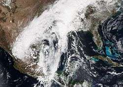
On March 7, an area of low pressure moved ashore in California as part of the pattern change that allowed the Golden State to receive much-needed rain. Late that evening, it dove into Mexico where it became detached from the main jet stream.[51] It then stalled for a few days and caused some extreme weather events, such as record-breaking heat in the Northeast, with areas achieving their earliest 80 °F day on record, which was the result of high pressure off the coast of Florida. It also caused historic floods in the South as well. Areas in Louisiana picked up to over 15 inches (38 cm) of rain, setting numerous records and triggering multiple flash floods from the extreme rainfall. The highest rainfall report was 23.22 inches (59.0 cm) near Monroe in Louisiana.[52] The historic events also caused rare snow in Mexico, which rarely receives snow at all.[51]
Vernal Equinox nor'easter
Early on March 18, a small disturbance moved through the High Plains, bringing up to as much as 10 inches (25 cm) of snow to areas in and around the Denver metropolitan area.[53] The disturbance quickly dissipated, but its energy in the upper atmosphere continued to move eastward towards the East Coast. Interacting with some moisture from the Gulf of Mexico, it was able to spawn some precipitation from west of the nation's capital (Washington D.C) to Cape May, New Jersey. Because of returning cold air, a few areas of wet snow were able to form in somewhere higher elevations, accumulations were light however, ranging from 1–3 inches (2.5–7.6 cm).
The system then moved off the East Coast and began to strengthen into a weak nor'easter late on March 20 and brought a swath of snowfall of anywhere from 1–12 inches (2.5–30.5 cm) from Philadelphia to Bangor, ME.,[54] and as it moved into high latitudes, it explosively deepened to a minimum pressure of 948 millibars (28.0 inHg) on March 23.[55]
Late March blizzard
On March 21, an area of low pressure moved ashore on the West Coast, with a limited amount of moisture available. Because of this precipitation was originally isolated. As it moved eastward on March 22 it started to intensify and as such snowfall began to become widespread. The storm also began to transition into an extratropical cyclone, achieving a peak of 989 millibars (29.2 inHg) two times on March 23.[56] Blizzard warnings were issued for areas around Denver due to the strong winds accompanying the system along with snowfall. Parts of Interstate 80 were shut down due to the extreme winter weather conditions.[57] Ahead of its cold front, thunderstorms began to fire up, prompting the National Weather Service to issue a tornado watch. A squall line later developed out of this as more storms began to fire up and move eastwards, with the severe weather threat shifting more to the east towards the East Coast.[58] The system also brought ice accumulations from 0.25–0.75 inches (6.4–19.1 mm) from the Midwest into New England. It then rapidly weakened and moved offshore late on March 25, dissipating the next day.
Early April clippers and cold wave
In the beginning of April, an unusual blast of cold air rushed into the Northeast, bringing temperatures 10–30 °F below average for most of the area.[23] Some areas even broke records for lowest April low temperatures. This was paired with a series of Alberta clippers moving through the Great Lakes through the weekend of April 2–3.[59] The first clipper brought mainly high winds with it, knocking out power to a few thousand. This clipper then moved off the East Coast the same day and immediately began strengthening, its pressure dropping to 984 millibars (29.1 inHg) early on April 3, then further deepening to 954 millibars (28.2 inHg) on April 5.
The next clipper system was weaker then the previous one, alias only reaching a peak of 997 millibars (29.4 inHg) early on April 3, however, gained enough characteristics to become a full-fledged winter storm. Moving fairly quickly, this snowmaker began to drop snow near the Great Lakes at its peak intensity, and as it neared the Northeast, snow began to spread eastward. Early on April 4, light to moderate snow had reached Boston, with locally heavier snowfall rates at times, which made visibility low.[25] By mid-day, rainfall began to fire up along the clipper's cold front, spreading into New York City and New Jersey. It began to accelerate at the same time, moving off the coast late the same day. Total snowfall accumulations from this system ranged from 2–6 inches (5.1–15.2 cm), in a swath extending from the Great Lakes into southeastern New England.[25] A third system began plowing into the same areas on April 5–6, bringing more snow to the Great Lakes, and also the risk of wildfires in the Southwest.[59] This clipper transitioned into a storm complex early on April 7, and brought heavy rain to parts of the Tri-State Area. It lingered into early April 8 before finally retreating into Canada. A fourth clipper system reached the Mid-Atlantic states by the weekend of April 9–10, and brought both cold temperatures with it, and a swath of accumulating snow of 3–6 inches (7.6–15.2 cm) from the Ohio Valley into the southern parts of New Jersey.[59] As it approached the coastline, it began to transition into a small nor'easter. Because of temperatures being at or just above freezing, pockets of wet snow broke out in central New Jersey, with only accumulations on grassy surfaces, but areas further to the south picked up to 1–2 inches (2.5–5.1 cm).[59] The system moved offshore late by April 9, but brought some more cold temperatures behind it, setting more record lows.
The cold wave finally lifted out of the Northeastern United States by April 12, due to an imminent pattern change that would allow warm air to surge back into the region.[60]
Mid-April storm complex
On April 13, an area of disturbed weather associated with the jet stream moved ashore on the West Coast. Moving slowly it dived into the High Plains and Rocky Mountains during the course of the day on April 14. The upper-level low associated began to stall in the area and became cut off from the jet stream, while simultaneously producing a major snowstorm in the Rocky Mountains (with up to as much as 4 feet (48 in) of snowfall reported) and areas around the Denver metropolitan area and soaked the Central Plains and areas to the south with heavy rain (up to 20 inches (51 cm) of rainfall was reported early on April 18), flooding, severe thunderstorms, and possibly tornadoes.[61][62][63] Multiple rescue efforts had to be made in southeastern Texas early on April 18, due to the extremely heavy rainfall and flooding.[64][65] The upper low gradually moved out of the region by April 19, alias at a very slow rate.
Records
This is a list of records broken in North America during the 2015–16 winter.
United States
- 2nd warmest winter in Boston, MA (behind 2001–02).[66]
- Wettest December ever recorded (Lower 48 states)[67]
- Highest snowfall from a single snowstorm in Allentown, PA, Philadelphia, PA, Newark, NJ, New York City (LaGuardia and JFK airports), and Harrisburg, PA[67]
- Second wettest winter on record in Atlanta, and La Crosse, Wisconsin.[67]
- Wettest winter on record in Waterloo, Iowa and Lincoln, Nebraska [67]
- Warmest winter on record (Lower 48 states) [67]
Canada
- Above average temperatures for most of the country.[68]
- Below average precipitation in the southern quadrant of Canada, near the country border near the United States.[68]
References
- ↑ "Earth's Seasons: Equinoxes, Solstices, Perihelion, and Aphelion, 2000-2025" (PHP). Washington, D.C.: United States Naval Observatory. March 27, 2015. Archived from the original on August 15, 2015. Retrieved August 15, 2015.
- ↑ "Meteorological vs. Astronomical Seasons". NOAA National Centers for Environmental Information. June 21, 2013. Retrieved July 3, 2015.
- ↑ "Strong El Niño sets the stage for 2015-2016 winter weather". National Oceanic and Atmospheric Administration. October 15, 2015. Retrieved October 15, 2015.
- ↑ Monthly Temperature Forecasts (Period: December 2015 January-February 2016). Environment Canada (Report). Government of Canada. November 30, 2014.
- ↑ "Winter Storm Cara Recap". The Weather Channel. November 24, 2015. Retrieved March 27, 2016.
- ↑ "Tornadoes and Flooding Rain Hit the South, Midwest Christmas Week 2015". The Weather Channel. December 23, 2015. Retrieved March 27, 2016.
- ↑ "Winter Storm Goliath: Historic Southern Plains Blizzard Within Huge Swath of Snow, Ice (RECAP)". The Weather Channel. December 23, 2015. Retrieved March 27, 2016.
- ↑ "Regional Forecast Video". The Weather Channel. January 9, 2016. Retrieved March 27, 2016.
- ↑ "Winter Storm Jonas: Where Does it Rank Historically?". The Weather Channel. January 24, 2016. Retrieved March 27, 2016.
- ↑ "Winter Storm Kayla: Plains Blizzard is One of the Heaviest Snowstorms of Record in Parts of Nebraska". The Weather Channel. February 3, 2016. Retrieved March 27, 2016.
- ↑ "Winter Storm Lexi Drops More Than a Foot of Snow in Parts of New England (RECAP)". The Weather Channel. February 4, 2016. Retrieved March 27, 2016.
- ↑ "Winter Storm Mars Brings Blizzard Conditions to Massachusetts". The Weather Channel. February 7, 2016. Retrieved March 27, 2016.
- ↑ "Valentine's Day Arctic Outbreak Brings Coldest Temperatures in Decades to Boston, New York City". The Weather Channel. February 9, 2016. Retrieved March 27, 2016.
- ↑ "Winter Storm Olympia Drops Over 20 Inches of Snow in Parts of New York (RECAP)". The Weather Channel. February 12, 2016. Retrieved March 27, 2016.
- ↑ "Outbreak of Tornadoes, Damaging Winds Rips Through South, East Coast (RECAP)". The Weather Channel. February 23, 2016. Retrieved March 27, 2016.
- ↑ "Winter Storm Quo Dumps Snow From Upper Midwest to New England (RECAP)". The Weather Channel. February 29, 2016. Retrieved March 27, 2016.
- ↑ "Offshore Storm Scrapes Northeast; Brings Snow to Some in Early March". The Weather Channel. February 29, 2016. Retrieved March 27, 2016.
- ↑ "Severe Weather". The Weather Channel. March 10, 2016. Retrieved March 27, 2016.
- ↑ "Winter Storm Regis Brought Snow Across Eastern New England (RECAP)". The Weather Channel. March 20, 2016.
- ↑ "Winter Storm Selene (RECAP)". The Weather Channel. March 24, 2016. Retrieved March 27, 2016.
- 1 2 "Winter Storm Troy Dumps Feet of Snow on Rockies (RECAP)". The Weather Channel. March 31, 2016. Retrieved April 4, 2016.
- ↑ "At Least Two Dozen Tornadoes Strike Plains, Midwest and South; Late March to Early April (RECAP)". The Weather Channel. April 2, 2016. Retrieved April 4, 2016.
- 1 2 "Cold Temperatures to Continue in Great Lakes and Northeast (FORECAST)". April 4, 2016. Retrieved April 4, 2016.
- ↑ "2 Killed By Strong Winds in Massachusetts as Storm System Clobbers Midwest, Northeast". The Weather Channel. April 3, 2016. Retrieved April 4, 2016.
- 1 2 3 "Winter Storm Ursula Bringing Snow to Northeast (FORECAST)". The Weather Channel. April 4, 2016. Retrieved April 4, 2016.
- ↑ "April Snowstorm to Pound the Rockies, High Plains This Weekend (FORECAST)". The Weather Channel. April 13, 2016. Retrieved April 13, 2016.
- ↑ "Winter Storm Cara Recap". weather.com. November 29, 2015. Retrieved March 5, 2016.
- ↑ Erdman, John. "2015 Brought Warmest, Wettest December on Record in U.S.". Weather.com. The Weather Channel. Retrieved 23 January 2016.
- ↑ Nir, Sarah. "On a Tropical Christmas in New York, Traditions Melt Away". NYTimes.com. The New York Times. Retrieved 23 January 2016.
- ↑ "Montreal's Christmas Eve record-breaking temperature matches Los Angeles". cbc.ca. CBC News. Retrieved 23 January 2016.
- ↑ "Tornadoes sweep through Dallas area; significant damage". Msn.com. Retrieved December 27, 2015.
- ↑ "Five killed after tornadoes touch down near Dallas, as storms pummel Southeast". Fox News. December 26, 2015. Retrieved December 27, 2015.
- ↑ "LIVE: Severe storms strike Texas, blizzard unfolds over New Mexico". Accuweather.com. Retrieved December 27, 2015.
- 1 2 3 Winter Storm Jonas Detailed Updates The Weather Channel, January 24, 2016 (07:15 AM EST)
- ↑ Rogers, Katie (January 20, 2016). "Big Snowstorm Forecast Sends a Shiver Up the East Coast". MSN. The New York Times. Retrieved January 22, 2016.
- ↑ Johnson, Alex; Vinograd, Cassandra (January 20, 2016). "'Walloped': Nation's Capital in Crosshairs of Huge Snowstorm". NBC News. Retrieved January 22, 2016.
- ↑ Botelho, Greg; Payne, Ed (January 21, 2016). "Snowstorm threatens East; Washington, Baltimore under blizzard warnings". CNN. Retrieved January 22, 2016.
- ↑ "Winter Storm Mars Brings Blizzard Conditions to Massachusetts". weather.com. February 9, 2016. Retrieved February 19, 2016.
- ↑ Holly Yan and Azadeh Ansari, CNN (14 February 2016). "Record-breaking cold sweeps Eastern U.S.". CNN. Retrieved 16 February 2016.
- ↑ "Upstate NY mountain hits -114 degrees wind chill at summit". msn.com. Retrieved 16 February 2016.
- ↑ "Boston breaks Valentine's Day cold weather record - The Boston Globe". BostonGlobe.com. Retrieved 16 February 2016.
- 1 2 "Winter Storm Olympia Kills at Least 6; Tens of Thousands Left in the Dark". The Weather Channel. February 14, 2016. Retrieved February 27, 2016.
- ↑ "Storm Prediction Center 20160215's Storm Reports". Retrieved February 27, 2016.
- ↑ "NWS Damage Assessment Toolkit". Retrieved February 27, 2016.
- ↑ "Winter Storm Petros Brings Snow to Midwest, Great Lakes, Appalachians, Northeast (RECAP)". weather.com. February 25, 2016. Retrieved February 26, 2016.
- ↑ Montreal not affected by the storm - Meteomedia (fr)
- ↑ Meteomedia - Blizzard conditions in Quebec (fr)
- ↑ "WPC Surface Analysis Archive".
- ↑ "WPC Surface Analysis Archive".
- ↑ "Offshore Storm Developing, Snowy Friday Morning Commute in Northeast". weather.com. March 3, 2016. Retrieved March 4, 2016.
- 1 2 "Extreme March Weather Pattern Yields Snow in Mexico, Historic Flooding in South and Record Northeast Heat". weather.com. March 10, 2016. Retrieved March 10, 2016.
- ↑ "Over 26 Inches of Rain Triggers Record Flooding in the South, Including the Sabine River". weather.com. March 18, 2016. Retrieved March 25, 2016.
- ↑ "Winter Storm Regis Causes Travel Problems in High Plains". weather.com. March 18, 2016. Retrieved March 20, 2016.
- ↑ "Winter Storm Regis Takes Aim on East; Heaviest Snow Expected in New England (FORECAST)". weather.com. March 20, 2016. Retrieved March 20, 2016.
- ↑ "WPC Surface Analysis Archive".
- ↑ "WPC Surface Analysis Archive".
- ↑ "Winter Storm Selene a High Plains Blizzard; Heavy Snow Spreading to Upper Midwest (FORECAST)". March 23, 2016. Retrieved March 23, 2016.
- ↑ "Tornado Watch Issued as Severe Thunderstorms Target South, Ohio Valley Into Thursday Night (FORECAST)". March 24, 2016. Retrieved March 24, 2016.
- 1 2 3 4 "More Great Lakes, Northeast Snow; Plains High Winds, High Fire Danger Through Late Week". April 6, 2016. Retrieved April 6, 2016.
- ↑ "Pattern Change to Bring Warmer Conditions to Plains, Midwest and Northeast At Last (FORECAST)". April 10, 2016. Retrieved April 10, 2016.
- ↑ "Winter Storm Vexo: April Snowstorm to Pound the Rockies, High Plains This Weekend (FORECAST)". April 15, 2016. Retrieved April 15, 2016.
- ↑ "Plains Flood Threat Looms From Unusual April Multi-Day Heavy Rain Event (FORECAST)". April 15, 2016. Retrieved April 15, 2016.
- ↑ "Severe Threat, Including Tornadoes, Across Central States Through This Weekend (FORECAST)". April 10, 2016. Retrieved April 10, 2016.
- ↑ "Widespread Flooding Reported as Hundreds Call for Rescue in Houston Area". April 18, 2016. Retrieved April 18, 2016.
- ↑ "Dangerous Flood Threat Ongoing in Texas; Water Rescues Reported Near Houston (FORECAST)". April 18, 2016. Retrieved April 18, 2016.
- ↑ "Meteorological winter is over, and it's the second warmest on record". boston.com. March 1, 2016. Retrieved March 27, 2016.
- 1 2 3 4 5 "Lower 48 States Just Experienced Warmest Winter On Record". The Weather Channel. March 8, 2016. Retrieved March 27, 2016.
- 1 2 "El Niño to impact Canadian winter, here's what it brings". The Weather Network. January 27, 2016. Retrieved April 4, 2016.
External links
- 2015 Storm Summaries from the Weather Prediction Center
- 2016 Storm Summaries from the Weather Prediction Center
- Climate Prediction Center: What to expect this winter: NOAA's outlook reveals what conditions are favored across the US
| Preceded by 2014–15 |
North American winters 2015–16 |
Succeeded by 2016–17 |