2016 North Indian Ocean cyclone season
 | |
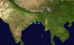
| Season summary map | |
| First system formed | 17 May 2016 |
|---|---|
| Last system dissipated | Season ongoing |
| Strongest storm1 | Roanu – 983 hPa (mbar), 85 km/h (50 mph) (3-minute sustained) |
| Depressions | 7 |
| Deep depressions | 5 |
| Cyclonic storms | 3 |
| Total fatalities | 356 total |
| Total damage | $1.78 billion (2016 USD) |
| 1Strongest storm is determined by lowest pressure | |
2014, 2015, 2016, 2017, 2018 | |
The 2016 North Indian Ocean cyclone season is a current event in the annual cycle of tropical cyclone formation. The North Indian Ocean cyclone season has no official bounds, but cyclones tend to form between April and December, with the two peaks in May and November. These dates conventionally delimit the period of each year when most tropical cyclones form in the northern Indian Ocean.
The scope of this article is limited to the Indian Ocean in the Northern Hemisphere, east of the Horn of Africa and west of the Malay Peninsula. There are two main seas in the North Indian Ocean — the Arabian Sea to the west of the Indian subcontinent, abbreviated ARB by the India Meteorological Department (IMD); and the Bay of Bengal to the east, abbreviated BOB by the IMD.
The official Regional Specialized Meteorological Centre in this basin is the India Meteorological Department (IMD), while the Joint Typhoon Warning Center releases unofficial advisories. On average, three to four cyclonic storms form in this basin every season.[1]
Season summary

The season officially started with the formation of Cyclone Roanu over in the Bay of Bengal on 17 May. The beginning of June witnessed no storms although a lot of low pressure areas formed over Bay of Bengal but none of these intensified into a depression. At the end of June, Depression ARB 01 formed but weakened within two days. July witnessed no storms until a deep depression formed in August under the influence of an upper air cyclonic circulation over Gangetic West Bengal. However, multiple low pressure areas occurred on the Bay of Bengal, with Cyclonic Storm Kyant forming in October.
Storms
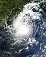
Cyclonic Storm Roanu
| Cyclonic storm (IMD) | |||
|---|---|---|---|
| Tropical storm (SSHWS) | |||
| |||
| Duration | 17 May – 22 May | ||
| Peak intensity | 85 km/h (50 mph) (3-min) 983 hPa (mbar) | ||


Under the influence of a trough, a low pressure area formed over the Bay of Bengal on 14 May.[2][3] It slowly consolidated, prompting the IMD to classify it as a depression on 17 May.[4] By the late hours of 17 May, a tropical cyclone formation alert (TCFA) was issued, following which the system was upgraded to tropical storm intensity by the JTWC.[5][6] The next day, the IMD upgraded the storm to a Deep Depression, prompting the issuance of cyclone warnings for the states of Andhra Pradesh and Odisha.[7] On 19 May, the IMD reported that the storm had reached cyclonic storm intensity, naming it Roanu.[8] The cyclone drifted in a northeastward track and continued to gain intensity until persistent wind shear and its proximity to land eventually caused it to start weakening on the same day.[9][10] However, the wind shear soon decreased, and Roanu reintensified as deep convection became established over and around the low-level circulation center (LLCC).[11][12] Moving generally east-northeastwards, the storm made landfall near Chittagong, Bangladesh on May 21, upon which it rapidly weakened.[13] It dissipated over Gangetic West Bengal on 22 May. The outer rainbands of the storm gave heavy rain in south Bengal including Kolkata.
Depression ARB 01
| Depression (IMD) | |||
|---|---|---|---|
| Tropical storm (SSHWS) | |||
| |||
| Duration | 27 June – 29 June | ||
| Peak intensity | 45 km/h (30 mph) (3-min) 993 hPa (mbar) | ||


On 27 June, a low pressure system intensified into a depression in the Arabian Sea. It turned westwards and moved to the cooler sections of the Arabian sea and gradually weakened. It dissipated on open waters on 29 June. Rain in Oman was the result of the depression.The depression that formed over the Northwest Arabian Sea and moved towards the Oman coast,and weakened. However, this weakened system continued to give rain over Oman in Al Sharqiya and Al Wusta region. Mostly southern parts of Oman was affected by this system.
Land Depression 01
| Deep Depression (IMD) | |||
|---|---|---|---|
| |||
| Duration | 9 August – 13 August | ||
| Peak intensity | 55 km/h (35 mph) (3-min) 986 hPa (mbar) | ||


A well-marked low-pressure area developed into a depression on 9 August, close to Canning, West Bengal, India. The next day, it moved northeastwards and intensified into a deep depression overland in Bangladesh, about 100 km (62 mi) east-northeast of Kolkata.[14]
Eight trawlers with a collective 118 fishermen aboard went missing over the Bay of Bengal during the storm;[15] at least 2 people are feared dead. The Indian Coast Guard launched a large-scale search and rescue operation to locate the missing fishermen.[16] All of the trawlers later returned to port, with one requiring assistance due to engine failure.[17] 5 fishermen went missing due to the storm out of which 2 died in the Hugli delta.
The deep depression moved towards Jharkhand on 11 August and quickly degenerated into a depression. Heavy rains fell over districts in West Bengal, such as Birbhum, Purulia and Bardhaman, and even in Kolkata, which led to flooding in some areas. Flooding also occurred in Jharkhand and West Bengal due to the increase of river waters in Damodar and Hugli.
Deep Depression BOB 02
| Deep Depression (IMD) | |||
|---|---|---|---|
| |||
| Duration | 16 August – 22 August | ||
| Peak intensity | 55 km/h (35 mph) (3-min) 987 hPa (mbar) | ||

A low pressure area formed over the Bay of Bengal in mid-August. It slowly consolidated, prompting the IMD to upgrade the system to a Depression on August 16.[18] The system slowly moved northwestwards, and intensified into a Deep Depression the following day, before making landfall over the coast of West Bengal between Digha and Diamond Harbour.
The system brought heavy rainfall to the eastern states of India, a region which was experiencing deficient monsoon rains. Chandabali and Balasore in Odisha recorded 146 mm (5.7 in) and 90 mm (3.5 in) of rainfall respectively in a span of 21 hours. Heavy rains fell in West Bengal, including Kolkata, which recorded winds of 70 kmph. At least 6 people have died in Kolkata directly due to the storm.[19] In Jharkhand, two teams of the National Disaster Response Force were deployed in Garhwa and Chatra districts of the state amid concerns of a possible flash flood.[20]
Cyclonic Storm Kyant
| Cyclonic storm (IMD) | |||
|---|---|---|---|
| Tropical storm (SSHWS) | |||
| |||
| Duration | 21 October – 28 October | ||
| Peak intensity | 85 km/h (50 mph) (3-min) 998 hPa (mbar) | ||

An area of low pressure formed over east-central Bay of Bengal on October 19.[21] It slowly consolidated and was upgraded to a Depression on October 21.[22] The system tracked over a marginally favorable environment, and intensified into a Deep Depression on October 23.[23] This was shortly followed by the JTWC issuing a TCFA for the system.[24] On October 24, both the IMD and JWTC reported the storm had reached tropical cyclone strength, naming it Kyant.[25][26] Initially following a northeastward path, the storm recurved westward off the coast of Myanmar along the souther periphery of a subtropical ridge towards the eastern coast of India.[27] Shortly thereafter, Kyant reached its peak intensity with sustained winds exceeding 85 km/h (50 mph) and a minimal central pressure of 998 mbar (29.47 inHg). Over the following days, the system commenced dry-air intrusion due to proximity to land, and within a span of six hours, it lost most of its convective structure and rapidly degenerated, as it drifted further west-southwestward. The JTWC issued their final warning at 21:00 UTC on October 26, and Kyant was last noted as a well-marked low pressure area off the coast of southern Andhra Pradesh on October 28.[28][29]
Depression BOB 04
| Depression (IMD) | |||
|---|---|---|---|
| |||
| Duration | 3 November – 6 November | ||
| Peak intensity | 45 km/h (30 mph) (3-min) 1000 hPa (mbar) | ||

An area of convection persisted in the Gulf of Thailand on October 31. It crossed the Malay Peninsula and drifted northwestwards into the Bay of Bengal over the next few days as it steadily organized. Being located in a highly favourable environment, the system rapidly consolidated, which inclined the JTWC to issue a TCFA on November 2.[30] The IMD reported that the area of low pressure had concentrated into a Depression on the next day.[31] However the storm moved into an area of very high wind shear, prompting the JTWC to cancel the TCFA on November 4.[32] The system gradually weakened as it tracked along the eastern coast of India over the following days, and dissipated near southeast Bangladesh on November 6. However, the weakened system gave heavy rain in coastal areas of West Bengal and Bangladesh, killing 80 people directly.[33]
Cyclonic Storm Nada
| Cyclonic storm (IMD) | |||
|---|---|---|---|
| Tropical storm (SSHWS) | |||
| |||
| Duration | 29 November – 2 December | ||
| Peak intensity | 75 km/h (45 mph) (3-min) 1000 hPa (mbar) | ||

Under the influence of a trough, low pressure area formed in extreme southeast Bay of bengal. It slowly consolidated enough to be classified as a depression BOB 05 on 29 November. This was followed by the JTWC issuing a TCFA for the system while it was rapidly concentrating to a deep depression. Remaining as a deep depression for a short time the storm quickly intensified into a cyclonic storm and named Nada by the IMD. In the wake of Nada, Tamil Nadu schools declared a two-day holiday as they had been turned to cyclone shelters. Shortly thereafter the storm reached its peak intensity of winds exceeding 75 km/h (45 mph) and a minimum central pressure of 1000 hPa (29.53 inHg). Just before landfall near Puducherry in Tamil Nadu the storm encountered high wind sheer and proximity to land the storm detoriated to a depression and crossed the coast and was last noted as a well marked low pressure area over South Karnataka. Tremendous rainfall in South India and Sri Lanka peaking 110 mm (4.3 in) in Jaffna, Sri Lanka. 12 deaths related to the cyclone have been reported.re during these days. In Tamil Nadu Meenambakkam received 351 mm of rainfall and Nungambakkam received 395 mm of rainfall in the last 24 hours.Mahabalipuram: 11 cm Cholavaram, Red Hills: 6 cm Muthupet: 5 cm Tirukattupalli, Anna University, Cheyyar, Vedasandur, Tirupuvanam, Dindigul, Uthiramerur, Chengalpet, Maduranthagam, Kamatchipuram: 4 cm each. Meenambakkam & Nungambakkam: 3 cm each in a span of 24 hrs due to the cyclone.
Storm names
Within this basin, a tropical cyclone is assigned a name when it is judged to have reached Cyclonic Storm intensity with winds of 65 km/h (40 mph). The names were selected by members of the ESCAP/WMO panel on Tropical Cyclones between 2000 and May 2004, before the Regional Specialized Meteorological Center in New Delhi started to assign names in September 2004. There is no retirement of tropical cyclone names in this basin as the list of names is only scheduled to be used once before a new list of names is drawn up. Should a named tropical cyclone move into the basin from the Western Pacific, then it will retain its original name. The next six available names from the List of North Indian Ocean storm names are below.
|
|
|
Season effects
This is a table of all storms in the 2016 North Indian Ocean cyclone season. It mentions all of the season's storms and their names, duration, peak intensities (according to the IMD storm scale), damage, and death totals. Damage and death totals include the damage and deaths caused when that storm was a precursor wave or extratropical low, and all of the damage figures are in 2016 USD.
| Name | Dates active | Peak classification | Sustained wind speeds |
Pressure | Land areas affected | Damage (USD) |
Deaths | Refs
" |
|---|---|---|---|---|---|---|---|---|
| Roanu | 17 – 22 May | Cyclonic storm | 85 km/h (50 mph) | 983 hPa (29.03 inHg) | Sri Lanka, East coast of India, Bangladesh, Myanmar | $1.7 billion | 227 | [34][35] |
| ARB 01 | 27 – 29 June | Depression | 45 km/h (30 mph) | 993 hPa (29.33 inHg) | Oman, Gujarat | None | None | |
| LAND 01 | 9 – 13 August | Deep depression | 55 km/h (35 mph) | 990 hPa (29.24 inHg) | East India, Bangladesh | Minimal | 20 | |
| BOB 02 | 16 – 22 August | Deep depression | 55 km/h (35 mph) | 995 hPa (29.39 inHg) | East India, Bangladesh | $40 million | 17 | |
| Kyant | 21 – 28 October | Cyclonic storm | 85 km/h (45 mph) | 997 hPa (29.44 inHg) | Andaman Islands, Myanmar, South India | None | None | |
| BOB 04 | 3 – 6 November | Depression | 45 km/h (30 mph) | 1000 hPa (29.53 inHg) | West Bengal, Bangladesh | $19 million | 80 | |
| Nada | 29 November – 2 December | Cyclonic storm | 75 km/h (45 mph) | 1000 hPa (29.53 inHg) | Sri Lanka, South India | $16 million | 12 | |
| Season Aggregates | ||||||||
| 7 systems | 17 May – present | 85 km/h (50 mph) | 983 hPa (29.03 inHg) | $1.78 billion | 356 | |||
See also
| Wikimedia Commons has media related to 2016 North Indian Ocean cyclone season. |
- 2016 Atlantic hurricane season
- 2016 Pacific hurricane season
- 2016 Pacific typhoon season
- South-West Indian Ocean cyclone seasons: 2015–16, 2016–17
- Australian region cyclone seasons: 2015–16, 2016–17
- South Pacific cyclone seasons: 2015–16, 2016–17
- South Atlantic tropical cyclone
References
- ↑ "Annual Frequency of Cyclonic Disturbances (Maximum Wind Speed of 17 Knots or More), Cyclones (34 Knots or More) and Severe Cyclones (48 Knots or More) Over the Bay of Bengal (BOB), Arabian Sea (AS) and Land Surface of India" (PDF). India Meteorological Department. Retrieved 30 October 2015.
- ↑ "Tropical Weather Outlook" (PDF). India Meteorological Department. Archived from the original (PDF) on 14 May 2016. Retrieved 14 May 2016.
- ↑ "All India Weather Summary and Forecast Bulletin, Night of 14 May 2016." (PDF). India Meteorological Department. Archived from the original (PDF) on 14 May 2016. Retrieved 14 May 2016.
- ↑ Yadav, B. P. "Special Tropical Outlook for the North Indian Ocean issued at 0600 UTC of 17 May 2016." (PDF). India Meteorological Department. Archived from the original (PDF) on 17 May 2016. Retrieved 17 May 2016.
- ↑ "Current Significant Tropical Weather Advisories ABIO10 (Indian Ocean) reissued at 18 May 2016, 0030 UTC". Joint Typhoon Warning Center. Archived from the original on 18 May 2016. Retrieved 18 May 2016.
- ↑ "Tropical Cyclone 01B (One) Warning #01 Issued on 18 May 2016 at 0900 UTC.". Joint Typhoon Warning Center. Archived from the original on 18 May 2016. Retrieved 18 May 2016.
- ↑ B.P. Yadav (18 May 2016). "Deep Depression BOB 01 Warning Bulletin 5 issued on 18 May 2016." (PDF). India Meteorological Department. p. 1. Archived from the original (PDF) on 18 May 2016. Retrieved 18 May 2016.
- ↑ Kotal, S. D. "Cyclonic Storm Roanu, Bulletin No. 9 issued at 0300 UTC, 19 May 2016." (PDF). India Meteorological Department. Archived from the original (PDF) on 19 May 2016. Retrieved 19 May 2016.
- ↑ "TROPICAL CYCLONE 01B (ROANU) WARNING NR 006". Joint Typhoon Warning Centre. Archived from the original on 19 May 2016. Retrieved 19 May 2016.
- ↑ "TROPICAL CYCLONE 01B (ROANU) WARNING NR 007". Joint Typhoon Warning Centre. Archived from the original on 19 May 2016. Retrieved 19 May 2016.
- ↑ "Tropical Cyclone 01B (Roanu) Warning #07". Joint Typhoon Warning Centre. Archived from the original on 19 May 2016. Retrieved 19 May 2016.
- ↑ "Tropical Cyclone 01B (Roanu) Warning #08". Joint Typhoon Warning Center. Archived from the original on 20 May 2016. Retrieved 20 May 2016.
- ↑ Mohapatra, M. "Tropical Storm Roanu Advisory No. 16 issued at 1500 UTC of 21 May 2016." (PDF). India Meteorological Department. Archived from the original (PDF) on 21 May 2016. Retrieved 21 May 2016.
- ↑ "Shipping Bulletin for Met. Area Viii(N), North of Equator Valid for 24/48 Hours From 0900 UTC 10th Aug 2016" (PDF). Regional Specialized Meteorological Centre. India Meteorological Department. 10 August 2016. p. 1. Archived from the original (PDF) on 10 August 2016. Retrieved 10 August 2016.
- ↑ "Most missing trawlers located". The Statesman. SNS. 11 August 2016. Retrieved 11 August 2016.
- ↑ "Two of missing Bengal fishermen feared dead BoB". The New Indian Express. IANS. 11 August 2016. Retrieved 11 August 2016.
- ↑ "Fishermen rescued from Bay of Bengal". The Hindu. Press Trust of India. 11 August 2016. Retrieved 11 August 2016.
- ↑ Mohapatra, M. "Special Tropical Weather Outlook for the North Indian Ocean issued at 0600 UTC of 17 August 2016." (PDF). India Meteorological Department. Archived from the original on 17 August 2016. Retrieved 17 August 2016.
- ↑ "Depression in Bay batters Odisha with heavy rains, more in offing.". Skymet Weather. Retrieved 17 August 2016.
- ↑ "Depression to bring more showers today.". The Times of India. Retrieved 18 August 2016.
- ↑ "Tropical Weather Outlook For North Indian Ocean (2016-10-19, 0600z)". RSMC New Delhi. Retrieved 22 October 2016.
- ↑ Mohapatra, M (21 October 2016). "Tropical Cyclone Bulletin 01 for Depression BOB 03". India Meteorological Department. Retrieved 21 October 2016.
- ↑ Mohapatra, M. "Tropical Cyclone bulletin 12 for Deep Depression BOB 03". India Meteorological Department. Retrieved 23 October 2016.
- ↑ "Tropical Cyclone Formation Alert for Deep Depression BOB03". Joint Typhoon Warning Center. Retrieved 23 October 2016.
- ↑ "Tropical Cyclone Warning 001 (TC 03B)". Joint Typhoon Warning Center. Retrieved 25 October 2016.
- ↑ Gopal, Neeta K. "Tropical Storm 'Kyant' Advisory One". India Meteorological Department. Retrieved 25 October 2016.
- ↑ "Tropical Cyclone 03B (Three) Warning 002". Joint Typhoon Warning Center. Retrieved 25 October 2016.
- ↑ "Tropical Cyclone 03B (Three) Warning 008 (Final)". Joint Typhoon Warning Center. Retrieved 27 October 2016.
- ↑ Kumar, Naresh. "Special Tropical Weather Outlook for the North Indian Ocean issued at 0300 UTC of October 28, 2016". India Meteorological Department. Retrieved 28 October 2016.
- ↑ "Tropical Cyclone Formation Alert (2016-11-02, 0500Z)". Joint Typhoon Warning Center. Retrieved 3 November 2016.
- ↑ Kumar, Naresh. "Depression over Central & adjoining southeast Bay of Bengal". India Meteorological Department. Retrieved 3 November 2016.
- ↑ "Tropical Cyclone Formation Alert Cancellation for 90B.". Joint Typhoon Warning Center.
- ↑ Mohapatra, M. "Special Tropical Outlook for the North Indian Ocean issued at 1500 UTC of 6 November 2016.". India Meteorological Department. Retrieved 7 November 2016.
- ↑ "Sri Lanka finds more landslide fatalities, warns of flood-triggered health crisis". The Japan Times. AFP-JIJI. Retrieved 23 May 2016.
- ↑ "Bangladesh avoids high death toll with cyclone evacuation". The New Indian Express. 23 May 2016. Retrieved 23 May 2016.
External links
Tropical cyclones of the 2016 North Indian Ocean cyclone season | ||
|---|---|---|
| ||
| ||