Late December 2015 North American storm complex
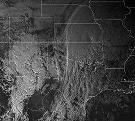 GOES-13 satellite image of the storm complex over the Southern United States on December 26 | |
| Type |
Extratropical cyclone Winter storm Ice storm Blizzard Tornado outbreak Flood |
|---|---|
| Formed | December 25, 2015 |
| Dissipated | December 30, 2015 |
| Lowest pressure | 989 mb (29.21 inHg) |
| Tornadoes confirmed | 32 |
| Max rating1 | EF4 tornado |
| Duration of tornado outbreak2 | 2 days, 2 hour, 4 minutes |
| Highest winds |
|
| Maximum snowfall or ice accretion | 41 in (1.0 m) at Bonito Lake, New Mexico |
| Damage | At least $1.2 billion |
| Power outages | ≥65,000 |
| Casualties | 59 fatalities |
| Areas affected | Southwestern, Central, and New England regions in the United States (Particularly Texas); Northern Mexico; Southeastern Canada. |
|
1Most severe tornado damage; see Enhanced Fujita scale 2Time from first tornado to last tornado Part of the 2015–16 North American winter | |
In late December 2015, a major storm complex developed and produced a tornado outbreak, winter storm, blizzard and ice storm in areas ranging from the Southwestern United States to New England.[1] Tornadoes impacted areas around Dallas, Texas.[2] Several states, especially Missouri, were hit with heavy rain and snow causing severe floods. As the system moved through the Great Lakes region, heavy rain, ice pellets and heavy snow fell in the entire region. Wintry mix moved through southern Ontario and Quebec had significant snowfall on December 29. Almost 60 people were killed in the storm system and its aftermath, which made it one of the deadliest of such systems of 2015 in the United States.[1]
Meteorological history

On December 25, a weak disturbance moved ashore on the West Coast. The disturbance started to move southeastwards into the Southwestern United States early on December 26. Continuing to move east, snow began to fall in the Upper Midwest, dropping up to 5–8 inches (13–20 cm), before rapidly dissipating.[3] As the initial area of low pressure moved over the United States–Mexico border, a southwards dip in the jet stream to the west had formed. In response to this, an upper-level low developed by evening on December 26. This upper-level low began to track to the north, drawing moisture from the Pacific Ocean and Gulf of Mexico. As it did so, a long cluster of heavy showers and thunderstorms fired up from eastern Oklahoma to southwestern Missouri, which set up a severe flooding event. Some areas picked up to over 1 foot (12 in) of rainfall, triggering several floods.[4]
At the same time, supercells began to appear in Texas. One of these produced an EF4 wedge tornado which ripped through parts of Garland and Rowlett, Texas, causing major damage.[2] As the storm complex began to move to the north, more supercells began to pop up with several more tornadoes being reported. By early on December 27, the supercells had begun to merge into a squall line, with tornado reports beginning to diminish, but occasionally a few isolated tornadoes would be produced by the storm.
While producing severe weather in the Deep South, the storm complex produced heavy snow and blizzard conditions in the southwestern parts of Texas through December 26–27, as frigid temperatures had spilled south into the area just the previous day before. Strong winds contributed to power outages and blowing and drifting snow. The snowfall continued throughout the majority of December 27, before tapering off near midnight as the storm system began to pull out of the region. In total, the storm complex dumped up to 2 feet (24 in) of snow in the western parts of Texas, a very rare and historic occurrence in the affected areas.[3] The storm had also produced a small but significant ice storm in the central parts of Texas, with ice accumulations ranging up to 1 inch (25 mm) in some areas, leading to thousands of power outages.[3]
By December 28, the storm complex had moved into the Central United States, producing more snow, ice, heavy rain, and severe weather in an area stretching from the Midwest into Louisiana. The upper-level low eventually began to take over as the dominant low, and had began to make a more east-northeastwards turn. Spreading a swath of 6–12 inches (15–30 cm) from Missouri to Maine, the storm complex continued to accelerate into southern Canada while producing more ice, rain and severe weather as the southern quadrant approached the East Coast.[3] Rain eventually reached areas like Philadelphia and New York City late on December 28, and persisted somewhat into the early morning hours of December 29. At this point, the storm system had already entered Canada, and its circulation was beginning to become elongated. The remnants of the storm eventually dissipated, early on December 30.[5]
Impact
Tornado outbreak
On December 26, 2015, the tornado outbreak portion of the storm system, with 32 tornadoes total confirmed, began when 12 tornadoes impacted Texas that evening, mostly in and around the Dallas–Fort Worth metroplex, killing 13 people,[6][7][8] which made it the deadliest tornado disaster in the area since the Dallas tornado of 1957, and added to the highest tornado death count in the U.S. for the month of December since 1953.[9][10] An EF3 tornado moved through multiple subdivisions in Ovilla and Glenn Heights, Texas on the south side of the metroplex, destroying numerous homes and two churches. Ten people in Garland, Texas died as a result of a large and powerful EF4 wedge tornado that also destroyed many homes in the neighboring suburb of Rowlett. An EF2 tornado killed two people in Copeville, while an EF1 caused another fatality near Blue Ridge. Additional tornadoes touched down across the Southern United States on December 27 and 28. Most of these tornadoes were weak, though EF2 tornadoes caused considerable damage near Marianna, Arkansas and Marshall, Texas.[11] More than 65,000 people lost power in the area due to the tornadoes.[12][13]
Damage from tornadoes in Texas alone is estimated at $1.2 billion.[8]
Flooding
The storm system was responsible for heavy rain that caused severe flooding in 13 states, with Missouri being especially impacted.[14][15] Parts of the state were hit with over 10 in (0.25 m) of heavy rainfall.[6] At least 14 people died due to the floods in Missouri alone.[16] In Union, Missouri, the Bourbeuse River rose to 34.22 ft (10.43 m), above the preceding record of 33.79 ft (10.30 m) which occurred on December 5, 1982.[15][17][18][19] More than 180 roads, including portions of Interstates 44, 55, and 70, and several bridges were closed.[20][21] The Meramec River, near St. Louis, crested 2 ft (0.61 m) above its previous record height, inundating nearby communities. At least 380 homes and 70 businesses were flooded in Franklin County.[20]
Approximately 140,000 sandbags were brought in to protect portions of the Bayshore subdivision in Arnold. At least 150 homes succumbed to flooding in the city.[20] More than 100 boat rescues were conducted in Eureka.[22]
Major flooding also occurred in south Alabama, where the Pea River in Elba, Alabama flooded. Most of the rainfall occurred on Christmas Eve day when training thunderstorms went over the same areas. All in all, a widespread 8-16 inches occurred.
Nine levees were topped—five along the Mississippi River, three along the Missouri River, and one along the Kaskaskia River—though the affected areas were predominantly unpopulated.[22][23] Large stretches of the Mississippi River were placed on alert due to projected major flooding.[24]
Flash flooding also claimed seven lives in Illinois, two in Oklahoma, one in Arkansas, and one in Georgia.[1][7][25][26]
Winter storm
The combination of heavy snow, strong winds, and bitterly cold temperatures resulted in blizzard conditions across most of New Mexico, southeastern Colorado, western Oklahoma and West Texas. Some places in this area had over 1–3 ft (30–91 cm) of snow but also snow drifts up to 12 feet (370 cm) high.[27] In the path of this Texas low, a swath of snow and ice impacted the central Plains and Midwest from Oklahoma to Wisconsin as the storm system moved northeastward toward the eastern Great Lakes. The storm system spread a wintry mix of snow, sleet and freezing rain to New York State and New England, disrupting travel in the region. At least 1 person in New Mexico, and 4 people in Oklahoma died as a direct result of the winter storm system.[1][7][28][29][30]
More than 750 flights were cancelled at Chicago O'Hare International Airport, and hundreds more at Detroit, Toronto and Montreal. Due to a strong Arctic air mass north of the system, parts of northern Michigan, Ontario and all Quebec suffered blizzard conditions, with moderate snow bands and moderate winds as well. 20–30 cm of snow (8–12 in) fell in Ottawa–Gatineau, less than 10 cm (4 in) in Toronto, and the greater Montreal region had 30–40 cm of snow (12–16 in).[1][3][6][7][31][32][33][34]
Four people died in Minnesota in a car accident linked to snow-covered roads.[35] Two people died from overexertion while clearing snow in Milwaukee, Wisconsin.[36] Other similar indirect deaths from the winter storm were reported in New Mexico (1 death), Missouri (2), Michigan (1), New York (1), Vermont (3), New Hampshire (1), and Maine (1).[1][28][37][38][39]
The dairy industry in eastern New Mexico and western Texas lost 30,000 cows to the storm.[40]
Confirmed tornadoes
| EF0 | EF1 | EF2 | EF3 | EF4 | EF5 | Total |
|---|---|---|---|---|---|---|
| 10 | 17 | 3 | 1 | 1 | 0 | 32 |
December 26 event
| EF# | Location | County / Parish | State | Start Coord. | Time (UTC) | Path length | Max width | Damage[note 2] | Summary | Refs |
|---|---|---|---|---|---|---|---|---|---|---|
| EF0 | NE of Byars | McClain | OK | 34°56′N 96°58′W / 34.94°N 96.96°W | 1957 | 0.1 mi (0.16 km) | 20 yd (18 m) | Unknown | A storm chaser reported a brief tornado. | [41] |
| EF0 | N of Hubbard | Hill | TX | 31°53′N 96°49′W / 31.89°N 96.81°W | 2003–2007 | 2.76 mi (4.44 km) | 50 yd (46 m) | $15,000 | A local fire department reported a tornado that damaged crops. | [42] |
| EF0 | NE of Eustace | Henderson | TX | 32°20′N 95°59′W / 32.33°N 95.99°W | 2044–2046 | 0.9 mi (1.4 km) | 40 yd (37 m) | $10,000 | Trained storm spotters observed a tornado that damaged crops over open land. | [43] |
| EF0 | NNE of Emory | Rains | TX | 32°54′N 95°44′W / 32.9°N 95.73°W | 2126–2127 | 0.69 mi (1.11 km) | 75 yd (69 m) | $0 | Trained storm spotters reported a brief tornado. | [44] |
| EF0 | NNW of Hillsboro | Hill | TX | 32°02′20″N 97°09′25″W / 32.039°N 97.157°W | 2310–2312 | 1.6 mi (2.6 km) | 80 yd (73 m) | $20,000 | Trained storm spotters reported a brief tornado. It remained over open country and caused no damage. | [45] |
| EF0 | S of Sulphur Springs | Hopkins | TX | 33°01′23″N 95°37′48″W / 33.023°N 95.63°W | 2333–2334 | 0.36 mi (0.58 km) | 25 yd (23 m) | $0 | A storm chaser observed a brief tornado. | [46] |
| EF0 | NE of Maypearl | Ellis | TX | 32°20′02″N 97°00′43″W / 32.334°N 97.012°W | 2343–2344 | 1.58 mi (2.54 km) | 50 yd (46 m) | $0 | A local fire department reported a brief tornado. | [47] |
| EF3 | E of Midlothian to Glenn Heights | Ellis, Dallas | TX | 32°27′44″N 96°54′32″W / 32.4623°N 96.909°W | 0001–0013 | 8.52 mi (13.71 km) | 125 yd (114 m) | $9,730,000 | A significant tornado began in Ellis County, damaging 77 single family homes, 23 of which were completely destroyed. After crossing into Dallas County, the tornado damaged 35 homes and an additional 10 mobile homes. Two churches were destroyed, and vehicles were thrown and mangled as well. 46 people were injured. | [48][49] |
| EF4 | Sunnyvale to Rowlett to Lake Ray Hubbard | Dallas, Rockwall | TX | 32°47′46″N 96°35′22″W / 32.796°N 96.5894°W | 0046–0102 | 13.04 mi (20.99 km) | 550 yd (500 m) | $26,800,000 | 10 deaths – A violent wedge tornado affected nearly 600 homes in Dallas County, particularly in the cities of Sunnyvale, Garland, and Rowlett. Of these, nearly 400 were destroyed, including a few well-constructed homes that were completely leveled. An additional 22 businesses were impacted, of which one was completely destroyed. Several mobile homes were also destroyed. An apartment complex sustained major structural damage, and multiple self-storage units were destroyed as well. Nine people were killed when their vehicles were lofted and thrown long distances from an elevated highway bridge at the George Bush Turnpike and Interstate 30 interchange, whereas another death occurred after a man sustained injuries in a collapsed home. 468 people were injured | [50][51] |
| EF0 | NE of Ennis | Ellis | TX | 32°23′08″N 96°31′48″W / 32.3855°N 96.53°W | 0100–0102 | 5.08 mi (8.18 km) | 150 yd (140 m) | $40,000 | A few barns were damaged. | [52] |
| EF2 | N of Lavon to N of Copeville | Collin | TX | 33°03′39″N 96°26′02″W / 33.0607°N 96.434°W | 0109–0115 | 5.29 mi (8.51 km) | 300 yd (270 m) | $1,400,000 | 2 deaths – A gas station and convenience store in Copeville was completely destroyed, killing two people inside. A large garage structure was destroyed, and over 30 homes and businesses in the area were damaged, some severely. 119 people were injured. | [53] |
| EF1 | W of Farmersville | Collin | TX | 33°09′31″N 96°23′44″W / 33.1587°N 96.3956°W | 0117–0123 | 4.47 mi (7.19 km) | 300 yd (270 m) | $1,500,000 | Several homes, including six mobile homes, were damaged or destroyed. | [54] |
| EF1 | SE of Blue Ridge | Collin | TX | 33°16′18″N 96°21′17″W / 33.2718°N 96.3546°W | 0133–0138 | 5.21 mi (8.38 km) | 100 yd (91 m) | $600,000 | 1 death – A log-construction frame home was damaged and a metal high-tension truss tower was blown over. Multiple mobile homes sustained major damage, with an infant being killed in one of them. Fence posts were pulled out of the ground and trees were downed as well. Two people were injured. | [55] |
December 27 event
| EF# | Location | County / Parish | State | Start Coord. | Time (UTC) | Path length | Max width | Damage [note 2] |
Summary | Refs |
|---|---|---|---|---|---|---|---|---|---|---|
| EF0 | WSW of De Kalb | Bowie | TX | 33°29′50″N 94°40′07″W / 33.4971°N 94.6687°W | 2106–2110 | 2.93 mi (4.72 km) | 75 yd (69 m) | $15,000 | The roof of a mobile home was partially removed, and several trees were snapped. | [56] |
| EF1 | NW of Gilmer | Upshur | TX | 32°43′55″N 94°59′07″W / 32.732°N 94.9854°W | 2124–2127 | 7.98 mi (12.84 km) | 1,338 yd (1,223 m) | $45,000 | A few outbuildings lost metal roofing panels, and several trees were downed, with a couple causing damage to two houses. | [57] |
| EF1 | NW of Hampton to ENE of Bearden | Calhoun, Ouachita | AR | 33°38′32″N 92°39′05″W / 33.6422°N 92.6514°W | 2132–2146 | 7.1 mi (11.4 km) | 100 yd (91 m) | $150,000 | Part of a roof was blown off of a couple industrial buildings at Highland Industrial Park, several empty rail cars were blown over, and, in Bearden, roofing material was ripped off several commercial buildings. Several trees were downed along the path. | [58][59] |
| EF1 | E of Patmos | Hempstead | AR | 33°30′46″N 93°31′36″W / 33.5127°N 93.5267°W | 2136–2137 | 0.84 mi (1.35 km) | 350 yd (320 m) | $15,000 | Pine trees were downed and a mobile home was damaged. | [60] |
| EF1 | ESE of Camden | Calhoun | AR | 33°26′04″N 92°33′12″W / 33.4345°N 92.5534°W | 2156–2207 | 7.22 mi (11.62 km) | 400 yd (370 m) | $55,000 | An intermittent tornado destroyed two sheds, damaged the roof on a home, and downed several pine trees on a path that passed through Hampton. One pine tree fell on and crushed two cars. | [61] |
| EF1 | E of Willisville | Nevada | AR | 33°28′30″N 93°16′54″W / 33.4751°N 93.2818°W | 2236–2244 | 3.85 mi (6.20 km) | 353 yd (323 m) | $100,000 | Several outbuildings were destroyed and a house sustained roof damage. Numerous trees were snapped and uprooted along the path. | [62] |
| EF2 | NNE of Marshall to SSE of Jefferson | Harrison | TX | 32°37′22″N 94°19′18″W / 32.6228°N 94.3216°W | 2239–2251 | 7.78 mi (12.52 km) | 300 yd (270 m) | $300,000 | Two mobile homes and several outbuildings were destroyed, with pieces tin roofing from one outbuilding being found at least a quarter-mile away. Multiple frame homes were damaged as well, and a pickup truck and storage trailer were tossed. Numerous trees were snapped and uprooted along the path. | [63] |
| EF1 | Hermitage to E of Banks | Bradley | AR | 33°26′58″N 92°10′21″W / 33.4495°N 92.1725°W | 2306–2318 | 7.11 mi (11.44 km) | 200 yd (180 m) | $75,000 | An awning was damaged at Hermintage School, part of the roof was ripped off a chicken house, a shed was destroyed, and a home sustained minor damage. Many trees were downed. | [64] |
| EF1 | ENE of Lodi | Cass | TX | 32°54′17″N 94°13′11″W / 32.9046°N 94.2196°W | 2309–2311 | 1.25 mi (2.01 km) | 200 yd (180 m) | $0 | Several trees were snapped or uprooted. | [65] |
| EF1 | W of Wilmar | Drew | AR | 33°35′03″N 91°57′23″W / 33.5843°N 91.9564°W | 0006–0017 | 5.74 mi (9.24 km) | 150 yd (140 m) | $60,000 | The roof was ripped off of a house and thrown onto a shed, and several pine trees were downed. | [66] |
| EF1 | W of Blanchard | Caddo | LA | 32°35′56″N 94°01′30″W / 32.5989°N 94.0249°W | 0210–0211 | 0.09 mi (0.14 km) | 41 yd (37 m) | $5,000 | Trees were snapped and uprooted along the path, and a mobile home sustained damage to its skirting. | [67] |
| EF1 | NNE of Blanchard | Caddo | LA | 32°36′26″N 93°52′40″W / 32.6071°N 93.8777°W | 0216–0220 | 2.27 mi (3.65 km) | 144 yd (132 m) | $250,000 | Tornado moved through two mobile home parks, damaging numerous mobile homes. One of the mobile homes was blown off its foundation, while another was crushed by a tree. One outbuilding was destroyed and two others were damaged. Numerous trees were snapped and uprooted along the path. | [68] |
| EF1 | SW of Homer | Claiborne | LA | 32°45′50″N 93°07′32″W / 32.7639°N 93.1255°W | 0510–0511 | 0.17 mi (0.27 km) | 21 yd (19 m) | $0 | Several trees were uprooted. | [69] |
December 28 event
| EF# | Location | County / Parish | State | Start Coord. | Time (UTC) | Path length | Max width | Damage[note 2] | Summary | Refs |
|---|---|---|---|---|---|---|---|---|---|---|
| EF1 | ENE of Walker | Livingston | LA | 30°29′58″N 90°49′45″W / 30.4995°N 90.8292°W | 0853–0856 | 1.94 mi (3.12 km) | 100 yd (91 m) | Unknown | A semi-truck was flipped and a trailer was moved. A building has its metal roof ripped off and a door blown inward. | [70] |
| EF1 | W of Laplace | St. John the Baptist | LA | 30°04′39″N 90°32′16″W / 30.0775°N 90.5378°W | 0920–0925 | 0.6 mi (0.97 km) | 150 yd (140 m) | Unknown | Roof and fence damage occurred, and several power poles were snapped. | [71] |
| EF2 | SW of Marianna | Lee | AR | 34°42′07″N 90°54′58″W / 34.702°N 90.9161°W | 1046–1051 | 5.75 mi (9.25 km) | 40 yd (37 m) | $50,000 | A mobile home was destroyed and homes sustained roof damage. | [72] |
| EF1 | NW of Seminary | Covington | MS | 31°32′26″N 89°31′48″W / 31.5405°N 89.5301°W | 1143–1151 | 5.59 mi (9.00 km) | 100 yd (91 m) | $100,000 | One barn was destroyed, several homes sustained minor damage, and numerous trees were snapped or uprooted. | [73] |
| EF1 | SW of Chumuckla | Santa Rosa | FL | 30°45′45″N 87°14′15″W / 30.7626°N 87.2375°W | 1430–1432 | 0.78 mi (1.26 km) | 75 yd (69 m) | $10,000 | A tornado tracked through a heavily forested area, uprooting pecan trees and snapping cedar and pines. The NWS survey team was unable to examine the entire path, and it is possible the tornado path extended further south. | [74] |
| EF0 | NNE of Trinity | Union | NC | 34°52′37″N 80°31′34″W / 34.877°N 80.526°W | 2158–2201 | 0.9 mi (1.4 km) | 75 yd (69 m) | $50,000 | Five sheds and outbuildings were damaged or destroyed, the wall of one home sitting on concrete blocks was slightly shifted, a camper was rolled onto its side, and trees were downed. | [75] |
Notes
References
- 1 2 3 4 5 6 "Goliath: The Deadliest U.S Storm System of 2015". The Weather Channel. December 30, 2015.
- 1 2 "Tornadoes sweep through Dallas area; significant damage". Msn.com. Retrieved 2015-12-27.
- 1 2 3 4 5 "Winter Storm Goliath: Historic Southern Plains Blizzard Within Huge Swath of Snow, Ice (RECAP)". The Weather Channel. December 23, 2015.
- ↑ "Tornadoes and Flooding Rain Hit the South, Midwest Christmas Week 2015". December 28, 2015. Retrieved April 17, 2016.
- ↑ "WPC Surface Analysis". December 30, 2015. Retrieved April 17, 2016.
- 1 2 3 "REPORTS: Severe storms slam Texas as flooding and blizzard conditions struck the Plains". AccuWeather.
- 1 2 3 4 "Crippling blizzard follows deadly tornadoes in Texas". Cbsnews.com. December 27, 2015.
- 1 2 "Man injured by Garland tornado dies; death toll to 12". KSAT. Associated Press. January 9, 2016. Retrieved January 9, 2016.
- ↑ "Weather". The Weather Channel. December 28, 2015.
- ↑ "Tornadoes: Deadliest December in 62 Years". The Weather Channel. December 29, 2015.
- ↑ "Five killed after tornadoes touch down near Dallas, as storms pummel Southeast". Fox News. 2006-10-01. Retrieved 2015-12-27.
- ↑ "LIVE: Severe storms strike Texas, blizzard unfolds over New Mexico". Accuweather.com. Retrieved 2015-12-27.
- ↑ "NWS Damage Assessment Toolkit". Apps.dat.noaa.gov. Retrieved 2016-01-02.
- ↑ Eric Sykes (29 December 2015). "Major flooding in Union, Mo; businesses underwater". Retrieved 31 December 2015.
- 1 2 "Missouri Flooding Six Dead". CNN. 27 December 2015.
- ↑ ABC News. "See Dramatic Rescue of Man, Dog From Roof of Missouri Home in Historic Flood". ABC News.
- ↑ Eric Sykes (29 December 2015). "Major flooding in Union, Mo; businesses underwater". Retrieved 30 December 2015.
- ↑ "Flood Safety and Preparedness". The Weather Channel. 29 December 2015. Retrieved 30 December 2015.
- ↑ "Rain, sleet, snow, flooding continuing in Missouri Monday morning". Missourinet.
- 1 2 3 Tim O'Neil; Walker Moskop (January 1, 2016). "Meramec River's record flood wipes out commute for thousands". St. Louis Post-Dispatch. Retrieved January 1, 2016.
- ↑ "Flooding closes more than 180 roads in Missouri". WDAF. Associated Press. December 28, 2015. Retrieved January 1, 2016.
- 1 2 "Roadways begin to reopen in flood-ravaged St. Louis area". Fox News. Associated Press. January 1, 2016. Retrieved January 1, 2016.
- ↑ "Towns south of St. Louis brace for Mississippi River floods". CBS News. Associated Press. January 1, 2016. Retrieved January 1, 2016.
- ↑ Ted Gregory; Robert McCoppin (December 31, 2015). "Mississippi River towns on high alert even as flooding forecast improves". Chicago Tribune. Retrieved January 1, 2016.
- ↑ "UPDATE: 5 people die in flash flood in Illinois". Associated Press.
- ↑ Jonathan Andrews; Rodney Harris; Meghan Packer; Melinda Roeder (December 28, 2015). "2 deaths in Georgia linked to storms - CBS46 News".
- ↑ Sean Federico-O'Murchu. "New Mexico Couple Buried in Car for 20 Hours During Monster Snowdrift". NBC News.
- 1 2 ABC News. "New Mexico Works to Unbury After Record Snow Storm". ABC News.
- ↑ ABC News. "At Least 3 Weather-Related Deaths in Oklahoma". ABC News.
- ↑ ABC News. "Craig Strickland: Country Singer's Body Found". ABC News.
- ↑ "Winter Storm – December 26 – 29, 2015". GCCapitalIdeas.com. Retrieved 2015-12-30.
- ↑ "Midwest flooding death toll rises as dangers remain". Cbsnews.com. December 30, 2015. Retrieved 2015-12-30.
- ↑ ABC News. "Latest: More Than 2,800 Flights Canceled Amid Winter Storm". ABC News.
- ↑ Météo Média (40 cm in Montreal)(fr)
- ↑ Forum News Service. "Minnesota family of four killed in Christmas weekend crash". INFORUM.
- ↑ Katie Delong; Bret Lemoine (December 29, 2015). "Two men pronounced dead in Milwaukee after collapsing while cleaning up snow". WITI. Retrieved January 1, 2016.
- ↑ "3-vehicle crash claims life of Arenac County man, 50". MLive.com.
- ↑ ABC News. "Truck, SUV Collide on Slushy Vermont Mountain Road; 3 Dead". ABC News.
- ↑ ABC News. "1 Dead in New Hampshire Crash With Secret Service Agents". ABC News.
- ↑ Hinckley, Story (2016-01-03). "How a freak blizzard wrecked Texas's dairy industry". Christian Science Monitor. Retrieved 3 January 2016.
- ↑ Oklahoma Event Report: EF0 Tornado (Report). National Climatic Data Center. National Weather Service Weather Forecast Office in Norman, Oklahoma. 2015. Retrieved May 1, 2016.
- ↑ Texas Event Report: EF0 Tornado (Report). National Climatic Data Center. National Weather Service Weather Forecast Office in Fort Worth, Texas. 2015. Retrieved May 1, 2016.
- ↑ Texas Event Report: EF0 Tornado (Report). National Climatic Data Center. National Weather Service Weather Forecast Office in Fort Worth, Texas. 2015. Retrieved May 1, 2016.
- ↑ Texas Event Report: EF0 Tornado (Report). National Climatic Data Center. National Weather Service Weather Forecast Office in Fort Worth, Texas. 2015. Retrieved May 1, 2016.
- ↑ Texas Event Report: EF0 Tornado (Report). National Climatic Data Center. National Weather Service Weather Forecast Office in Fort Worth, Texas. 2015. Retrieved May 1, 2016.
- ↑ Texas Event Report: EF0 Tornado (Report). National Climatic Data Center. National Weather Service Weather Forecast Office in Fort Worth, Texas. 2015. Retrieved May 1, 2016.
- ↑ Texas Event Report: EF0 Tornado (Report). National Climatic Data Center. National Weather Service Weather Forecast Office in Fort Worth, Texas. 2015. Retrieved May 1, 2016.
- ↑ Texas Event Report: EF3 Tornado (Report). National Climatic Data Center. National Weather Service Weather Forecast Office in Fort Worth, Texas. 2015. Retrieved May 1, 2016.
- ↑ Texas Event Report: EF3 Tornado (Report). National Climatic Data Center. National Weather Service Weather Forecast Office in Fort Worth, Texas. 2015. Retrieved May 1, 2016.
- ↑ Texas Event Report: EF4 Tornado (Report). National Climatic Data Center. National Weather Service Weather Forecast Office in Fort Worth, Texas. 2015. Retrieved May 1, 2016.
- ↑ Texas Event Report: EF2 Tornado (Report). National Climatic Data Center. National Weather Service Weather Forecast Office in Fort Worth, Texas. 2015. Retrieved May 1, 2016.
- ↑ Texas Event Report: EF0 Tornado (Report). National Climatic Data Center. National Weather Service Weather Forecast Office in Fort Worth, Texas. 2015. Retrieved May 1, 2016.
- ↑ Texas Event Report: EF2 Tornado (Report). National Climatic Data Center. National Weather Service Weather Forecast Office in Fort Worth, Texas. 2015. Retrieved May 1, 2016.
- ↑ Texas Event Report: EF1 Tornado (Report). National Climatic Data Center. National Weather Service Weather Forecast Office in Fort Worth, Texas. 2015. Retrieved May 1, 2016.
- ↑ Texas Event Report: EF1 Tornado (Report). National Climatic Data Center. National Weather Service Weather Forecast Office in Fort Worth, Texas. 2015. Retrieved May 1, 2016.
- ↑ Texas Event Report: EF0 Tornado (Report). National Centers for Environmental Information. National Weather Service Weather Forecast Office in Shreveport, Louisiana. 2015. Retrieved May 12, 2016.
- ↑ Texas Event Report: EF1 Tornado (Report). National Centers for Environmental Information. National Weather Service Weather Forecast Office in Shreveport, Louisiana. 2015. Retrieved May 12, 2016.
- ↑ Arkansas Event Report: EF1 Tornado (Report). National Centers for Environmental Information. National Weather Service Weather Forecast Office in Little Rock, Arkansas. 2015. Retrieved May 12, 2016.
- ↑ Arkansas Event Report: EF1 Tornado (Report). National Centers for Environmental Information. National Weather Service Weather Forecast Office in Little Rock, Arkansas. 2015. Retrieved May 12, 2016.
- ↑ Arkansas Event Report: EF1 Tornado (Report). National Centers for Environmental Information. National Weather Service Weather Forecast Office in Shreveport, Louisiana. 2015. Retrieved May 12, 2016.
- ↑ Arkansas Event Report: EF1 Tornado (Report). National Centers for Environmental Information. National Weather Service Weather Forecast Office in Shreveport, Louisiana. 2015. Retrieved May 12, 2016.
- ↑ Arkansas Event Report: EF1 Tornado (Report). National Centers for Environmental Information. National Weather Service Weather Forecast Office in Shreveport, Louisiana. 2015. Retrieved May 12, 2016.
- ↑ Texas Event Report: EF2 Tornado (Report). National Centers for Environmental Information. National Weather Service Weather Forecast Office in Shreveport, Louisiana. 2015. Retrieved May 12, 2016.
- ↑ Arkansas Event Report: EF1 Tornado (Report). National Centers for Environmental Information. National Weather Service Weather Forecast Office in Little Rock, Arkansas. 2015. Retrieved May 12, 2016.
- ↑ Texas Event Report: EF1 Tornado (Report). National Centers for Environmental Information. National Weather Service Weather Forecast Office in Shreveport, Louisiana. 2015. Retrieved May 12, 2016.
- ↑ Arkansas Event Report: EF1 Tornado (Report). National Centers for Environmental Information. National Weather Service Weather Forecast Office in Little Rock, Arkansas. 2015. Retrieved May 12, 2016.
- ↑ Louisiana Event Report: EF1 Tornado (Report). National Centers for Environmental Information. National Weather Service Weather Forecast Office in Shreveport, Louisiana. 2015. Retrieved May 12, 2016.
- ↑ Louisiana Event Report: EF1 Tornado (Report). National Centers for Environmental Information. National Weather Service Weather Forecast Office in Shreveport, Louisiana. 2015. Retrieved May 12, 2016.
- ↑ Louisiana Event Report: EF1 Tornado (Report). National Centers for Environmental Information. National Weather Service Weather Forecast Office in Shreveport, Louisiana. 2015. Retrieved May 12, 2016.
- ↑ Louisiana Event Report: EF1 Tornado (Report). National Centers for Environmental Information. National Weather Service Weather Forecast Office in New Orleans, Louisiana. 2015. Retrieved May 12, 2016.
- ↑ Louisiana Event Report: EF1 Tornado (Report). National Centers for Environmental Information. National Weather Service Weather Forecast Office in New Orleans, Louisiana. 2015. Retrieved May 12, 2016.
- ↑ Arkansas Event Report: EF2 Tornado (Report). National Centers for Environmental Information. National Weather Service Weather Forecast Office in Memphis, Tennessee. 2015. Retrieved May 12, 2016.
- ↑ Mississippi Event Report: EF1 Tornado (Report). National Centers for Environmental Information. National Weather Service Weather Forecast Office in Jackson, Mississippi. 2015. Retrieved May 12, 2016.
- ↑ Florida Event Report: EF1 Tornado (Report). National Centers for Environmental Information. National Weather Service Weather Forecast Office in Mobile, Alabama. 2015. Retrieved May 12, 2016.
- ↑ North Carolina Event Report: EF0 Tornado (Report). National Centers for Environmental Information. National Weather Service Weather Forecast Office in Greenville-Spartanburg, South Carolina. 2015. Retrieved May 12, 2016.