2013–14 Atlantic winter storms in Europe
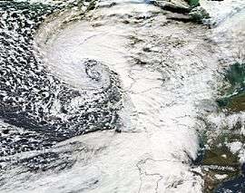
 NOAA North Atlantic wind speed anomaly January–February 2014 | |
| Type |
Extratropical cyclones European windstorms |
|---|---|
2013–14 Atlantic winter storms in Europe were a series of winter storms affecting areas of Atlantic Europe and beyond. The French Atlantic coastal regions (chiefly Brittany), South West and Southern England, West Wales, Ireland, Spanish Atlantic coastal regions (particularly Galicia) were especially affected by a "conveyor belt" series of high-precipitation storms (mostly not exceptional for their winds) and by high tides. Many storms were explosively deepened by a strong jet stream, many deepening below 950 hPa. The repeated formation of large deep lows over the Atlantic brought storm surges and large waves which coincided with some of the highest astronomical tides of the year and caused coastal damage. The low pressure areas brought heavy rainfalls which led to flooding, which became most severe over parts of England such as at the Somerset Levels. The repeated storms fit into a pattern of disturbed weather in the Northern Hemisphere, which saw from November 2013 a disturbance to the jet stream in the western Pacific, which propagated eastwards bringing a warm winter to Alaska, drought to California, and repeated cold air outbreaks to the eastern USA where the 2013–14 North American cold wave resulted.
Autumn 2013
The end of October brought the St. Jude storm, ranked within the top 10 most severe storms in the autumn across southern England in the last 40 years.[1] following the St. Jude storm a series of low pressure systems swept across western Europe bringing winds and rain, though not developing anywhere near as deeply as the St. Jude storm. A low named Godehard[Note 1] was the strongest of these low pressure areas and brought some disruption to Wales, with a gust of 89 miles per hour (143 km/h) recorded at Mumbles.[2] Storm-force winds left 10,000 homes without electricity in Wales on the first weekend of November 2013.[2] On 2 November the M4 Motorway was closed between Margam and Pyle due to the weather, and a roof canopy at the Princess of Wales Hospital Bridgend was damaged.[2] The old Severn Bridge on the M48 motorway was closed, with speed restrictions in place on the Second Severn Crossing. The M4 at Briton Ferry -where the motorway crosses the Neath- also saw speed restrictions and the Britannia Bridge to Anglesey and the Cleddau Bridge in Pembrokeshire also saw speed restrictions enacted. Natural Resources Wales warned of localised flooding with sea spray and overtopping of sea defences along the Pembrokeshire, Ceredigion and Newport coasts.[2] The low pressure also brought large waves to Aberystwyth which caused some disruption to seafront properties.[3]
November/December 2013
Late November and early December saw an area of high pressure positioned to the west of Britain and Ireland, this directed the westerly path of weather systems moving over the Atlantic to the north of the UK, along which the storms developed before impacting across the Nordic countries. Lows moving to the north of the United Kingdom meant that November was fairly dry for the country.[1] December saw long periods of calm conditions in France also with dry and sunny weather predominating. A change in the weather regime began as active depressions brought strong rain and snowfall to the mountains towards the month end. Until December 13, France (and UK and Ireland) were protected by a powerful anticyclone stretched from the Maghreb to the British Isles, which deflected the Atlantic storm track north into Scandinavia.[4] The Nordic nations were affected by a series of storms, including Hilde (17 November),[5] Oskari (1 dec),[6] Xaver (5-7 Dec), Ivar (12 Dec)[5] and Zaki and Adam (14-15 Dec). Cyclone Xaver is predominantly known for the North sea storm surge of 5 December in the UK. The high pressure over Britain, Ireland and the Atlantic moved east during mid December, opening the way for areas of low pressure to reach western Europe. During mid-December a strong temperature gradient established over eastern North America (temperatures in New York 21 °C, Montreal -7 °C), which enhanced the jetstream in the North Atlantic.[7][8] The lows moved under this powerful jet stream where they explosively deepened before reaching Western Europe.[9]
Christmas and New Year storms
Bernd (18–19 December)
 | |
| Formed | 17 December 2013 |
|---|---|
| Dissipated | 21 December 2013 |
| Lowest pressure | 947 hectopascals (28.0 inHg)[10] |
The first storm of this period was named Bernd,[Note 1] it was also given the name Emily after Emily Brontë the author, who died on December 19 165 years ago, and who wrote Wuthering Heights which featured constant stormy weather by some press.[11][12][13] Met Eireann issued red warnings for wind at 9:00am 18 December to Donegal, Galway, Leitrim, Mayo and Sligo.[13] The UK Met Office issued orange warnings for the Highlands, Western Isles, Strathclyde and Northern Ireland.[14]
| UK Met Office maximum hourly gust speed 18 Dec 1800 – 19 Dec 0700 .[15] | |||
|---|---|---|---|
| Site | Area | Elevation (m) | Max gust speed |
| Needles Old Battery | Isle of Wight | 80 | 94 miles per hour (151 km/h) |
| South Uist Range | Western Isles | 4 | 90 miles per hour (140 km/h) |
| Tiree | Argyll | 9 | 87 miles per hour (140 km/h) |
| Plymouth, Mountbatten | Devon | 50 | 85 miles per hour (137 km/h) |
| Castlederg | Tyrone | 49 | 84 miles per hour (135 km/h) |
| Pembrey Sands | Dyfed | 3 | 82 miles per hour (132 km/h) |
| Capel Curig | Gwynedd | 216 | 81 miles per hour (130 km/h) |
| Stornoway Airport | Western Isles | 15 | 77 miles per hour (124 km/h) |
| Altnaharra | Sutherland | 81 | 77 miles per hour (124 km/h) |
| Fair Isle | Shetland | 57 | 76 miles per hour (122 km/h) |
| UK Met Office 24 Hour Rainfall Totals 18 Dec 0700 – 19 Dec 0700, 2013.[15] | ||
|---|---|---|
| Site | Area | Precipitation (mm) |
| Tredegar | Gwent | 38.4 |
| Cardinham, Bodmin | Cornwall | 35 |
| Whitechurch | Dyfed | 34.4 |
| Tyndrum | Perthshire | 32.2 |
| Libanus | Powys | 30.8 |
| Shap | Cumbria | 30.6 |
| Okehampton | Devon | 30.6 |
| Keswick | Cumbria | 28.8 |
| Tulloch Bridge | Inverness-shire | 27 |
| Bala | Gwynedd | 26.4 |
Dirk (23–24 December)
 | |
| Formed | 21 December 2013 |
|---|---|
| Dissipated | 28 December 2013 |
| Lowest pressure | 929 hectopascals (27.4 inHg) |
Dirk formed over North America,[16] some storminess was associated with the low in Canada, before it moved into the Atlantic. The preceding weather in North America saw a steep temperature gradient (temperatures in New York 21°C, Montreal -7°C) which enhanced the jetstream in the North Atlantic.[17] The low moved under this powerful jet stream where it explosively deepened before reaching Western Europe.[16][18]
Deepening below 935 hectopascals (27.6 inHg) is considered uncommon in the North Atlantic, but has been recorded on a number of occasions, measured from ships transiting the ocean and from land based-recording stations.[19] Offshore the minimum low pressure of the "Dirk" storm was forecast to reach a low of 927 hectopascals (27.4 inHg).[20][21]
On land the low pressure during the storm was measured at 936.8 hectopascals (27.66 inHg) on 24 December at Stornoway, Isle of Lewis off the north west coast of Scotland.[22][23] This the lowest measured in Britain and Ireland since 1886 (127 years), when a low of 931.2 hectopascals (27.50 inHg) was recorded in Belfast, Northern Ireland.[22] The most recent low pressure record near such values in Stornoway was measured on 20 December 1982 at 937.6 hectopascals (27.69 inHg).[22] The all-time low pressure record for the British Isles remains at 925.4 hectopascals (27.33 inHg), recorded at Ochtertyre, Crieff in Perthshire on 26 January 1884. However, this was beaten by the 728 mb during December 2015's Storm Frank.[22]
At the southernmost tip of the Faroe Islands a low air pressure of 932.2 hPa was recorded on Christmas Eve at Akraberg lighthouse.[24] This was not as low as the Faroese record of 930.3 hPa, set at Vagar airport during the passage of the Braer Storm of January 1993.[24]
Erich (26–27 December)
 | |
| Formed | 25 December 2013 |
|---|---|
| Dissipated | 1 January 2014 |
| Lowest pressure | 944 hectopascals (27.9 inHg) |
| UK Met Office maximum hourly gust speed 0000 27 December to 14:30 27 December.[25] | |||
|---|---|---|---|
| Site | Area | Elevation (m) | Max gust speed |
| Aberdaron | Gwynedd | 95 | 102 miles per hour (164 km/h) |
| Capel Curig | Gwynedd | 216 | 87 miles per hour (140 km/h) |
| Mumbles Head | West Glamorgan | 43 | 85 miles per hour (137 km/h) |
| St Bees Head | Cumbria | 124 | 85 miles per hour (137 km/h) |
| Inverbervie | Kincardineshire | 134 | 81 miles per hour (130 km/h) |
| Valley | Gwynedd | 10 | 81 miles per hour (130 km/h) |
| Lake Vyrnwy | Powys | 360 | 78 miles per hour (126 km/h) |
| Mona | Anglesey | 60 | 78 miles per hour (126 km/h) |
| Needles Old Battery | Isle of Wight | 80 | 78 miles per hour (126 km/h) |
| Dundrennan | Kirkcudbrightshire | 113 | 77 miles per hour (124 km/h) |
| Pembrey Sands | Dyfed | 3 | 76 miles per hour (122 km/h) |
| UK Met Office 24 Hour Rainfall Totals 0000 27 December to 14:30 27 December.[25] | ||
|---|---|---|
| Site | Area | Precipitation (mm) |
| Tulloch Bridge | Inverness-shire | 38 |
| Tyndrum | Perthshire | 37.8 |
| Charterhouse | Roxburghshire | 37.8 |
| *Kielder Castle | Northumberland | 33.2 |
| Achnagart | Ross & Cromarty | 32.8 |
| Redesdale Camp | Northumberland | 28.6 |
Felix & Gerhard

A stormy period between Christmas and New Year followed as Weather fronts associated with the lows Felix (December 30) and Gerhard (January 1) passed over the UK which brought further rainfall and some stormy conditions.
The Felix low was more remote from European mainland and brought strong tightening of isobars across NW France, where winds of 141 km/h were reported in Camaret-sur-Mer, Brittany. Low near Iceland brought winds up to 140 km/h to that country, and disrupted traffic and heavy rainfall and brought more flooding to the United Kingdom.[26] At Croyde Bay in north Devon a woman was rescued from sea who later died on 31 December.[27]
27 year old man swept out to sea on Loe Bar Porthleven Cornwall New Year's Eve, and on 1 January a man was found dead on the banks of River Torridge in Bideford, Devon.[28] Over the holiday period, several New Year outdoor swimming events were cancelled.
Notes
- ^ Naming conventions (where possible) follow those adopted by the Free University of Berlin's adopt a vortex scheme. Names from other sources referenced in article.
References
- 1 2 "2013: Average figures mask some notable highlights". Met Office News Blog. 31 December 2013. Retrieved 9 February 2014.
- 1 2 3 4 "Storm-force winds bring damage and 10,000 homes lose power". BBC News. 3 November 2013. Retrieved 11 November 2013.
- ↑ "Aberystwyth seafront like 'war zone' after storm waves". BBC News. 4 November 2013. Retrieved 26 August 2014.
- ↑ "BILAN DÉCEMBRE 2013 : grand calme avant les tempêtes, de la douceur". Meteo-Paris.com (in French). 30 December 2013. Retrieved 29 March 2014.
- 1 2 "Norske ekstremvær får navn" (in Norwegian). Norwegian Meteorological Institute. Retrieved 18 November 2015.
- ↑ "2013 – an exceptionally warm year". Finnish Meteorological Institute. 3 January 2014. Retrieved 18 November 2015.
- ↑ Burt, Stephen (March 2014). "Britain's lowest barometric pressure since 1886". Weather. 69 (3). Bibcode:2014Wthr...69...79B. doi:10.1002/wea.2285. Retrieved 17 February 2015.
- ↑ Hammond, John (24 December 2013). "Why is it so stormy?". Weather BBC News. Retrieved 24 December 2013.
- ↑ Taylor, Matt. "UK stormy weather explained". BBC News. Retrieved 24 December 2013.
- ↑ "December 19, 2013 surface analysis". Met Office. Retrieved 26 December 2013.
- ↑ Rao, Nathan (18 December 2013). "Hold on to your hats! 100mph Storm Emily will roar in tonight with 'a sting in her tail'". Daily Express. Retrieved 9 February 2014.
- ↑ "Christmas will be a washout as storms continue". AOL Travel. 19 December 2013. Retrieved 19 December 2013.
- 1 2 Cromie, Claire (18 December 2014). "Storm Emily's 80mph winds could disrupt Northern Ireland power supplies and transport again". Belfast Telegraph. Retrieved 18 March 2014.
- ↑ "Storm Emily: Met Office Upgrade Weather Warning To Amber For Scotland And Northern Ireland". Weather Forecast blog. 18 December 2013. Retrieved 15 March 2014.
- 1 2 "Updated Wind and Rainfall totals for 18th to 19th December". Met Office. 19 December 2014. Retrieved 18 March 2014.
- 1 2 Saary, Elizabeth (23 December 2013). "UK Stormy weather to last 48 hours". BBC News. Retrieved 23 December 2013.
- ↑ Hammond, John (24 December 2013). "Why is it so stormy?". Weather BBC News. Retrieved 24 December 2013.
- ↑ Taylor, Matt. "UK stormy weather explained". BBC News. Retrieved 24 December 2013.
- ↑ Burt, S. D. (February 1987). "A NEW NORTH ATLANTIC LOW PRESSURE RECORD". Weather. 42 (2): 53–56. Bibcode:1987Wthr...42...53B. doi:10.1002/j.1477-8696.1987.tb06919.x.
- ↑ "Analysis 24/12/2013". NOAA. Retrieved 9 February 2014.
- ↑ "Winter storms, December 2013 to January 2014". Met Office. 12 February 2014. Retrieved 14 February 2014.
- 1 2 3 4 Graham, Eddie (24 December 2013). "Lowest pressure for 127 years recorded in Stornoway today (Confirmed) + Storm Videos". UHI-Mahara. Retrieved 25 December 2013.
- ↑ "Christmas Eve weather warning- lowest pressure in over 100 years". Stornoway Gazette. 23 December 2013. Retrieved 25 December 2013.
- 1 2 "Dramatiskt julväder i Sverige och övriga Europa". Swedish Meteorological and Hydrological Institute (in Swedish). 27 December 2013. Retrieved 7 January 2014.
- 1 2 "Wind and rainfall data 27 December 2013". Met Office. 27 December 2013. Retrieved 22 March 2014.
- ↑ "Dépression Felix : coup de vent en Bretagne et Normandie". Meteo-Paris.com (in French). 30 December 2013. Retrieved 29 March 2014.
- ↑ "Devon: Woman Dies After Being Swept Out To Sea". Sky News. 31 December 2014. Retrieved 15 March 2014.
- ↑ Keeble, Andy (1 January 2014). "Body of man discovered on banks of River Torridge". North Devon Gazette. Retrieved 15 March 2014.
External links
- House of Commons Environment, Food and Rural Affairs Committee Winter floods 2013–14
- Met Office and Centre for Ecology and Hydrology: The Recent Storms and Floods in the UK, February 9 2014.
- Met Office: Marine weather analysis - December 2013 & January 2014
- Environment Agency report
- Met Eireann: What’s up with the Weather this winter? Aidan Murphy 14 February 2014.
- Met Eireann: Winter 2013/2014, 3 March 2014
- Environment Agency Flickr Galleries:
| Wikimedia Commons has media related to Northern Atlantic cyclones. |
| Historical |  | |
|---|---|---|
| 1900s |
| |
| 2000s | ||
| 2015– Name our Storms | ||
| See also | ||