2011–12 El Hierro eruption

The 2011-2012 El Hierro eruption occurred just off the island of El Hierro, the smallest and farthest south and west of the Canary Islands (an Autonomous Community of Spain), in the Atlantic Ocean off the coast of Africa. The island is also the youngest in the volcanic chain. The October 2011 - March 2012 eruption was underwater, with a fissure of vents located approximately 2 km to the south of the fishing village of La Restinga on the southern coast of the island. As of June 2012, increased seismicity to the north-west of the vent suggests another phase in the area's volcanic activity - comprising just deep-seated magma movements with associated earthquakes and deformation of the island at this June 2012 stage - is under way. A second phase of eruptive activity has not yet occurred, and it does not necessarily follow that it will occur.
Earthquakes
Beginning on 17 July 2011, increased seismic activity was detected by the Instituto Vulcanológico de Canarias (Volcanological Institute of the Canary Islands) and National Geographic Institute’s seismic monitoring station located in Valverde.[1] The seismic monitoring network was increased in density on 21 July to allow better detection and location of the seismic events.[1] There was an earthquake swarm with in excess of 400 minor tremors between 20 July and 24 July;[1] by 27 July a further 320 earthquakes had been recorded.[2] On 25 August there were reports that some horizontal deformation had been detected, but that there was no unusual vertical deformation.[3] At that time, the total number of tremors had exceeded 4000.[3] By the end of September, the tremors had increased in frequency and intensity, with experts fearing landslides affecting the town of La Frontera, and also a small possibility of a volcanic eruption through a new vent. In late September emergency services evacuated several families in the areas at most risk, and made plans to evacuate the island if necessary.[4]
Submarine eruption: October 2011 - March 2012
Between 4.15 and 4.20am on 10 October 2011 the earthquake swarm changed behaviour and produced a harmonic tremor.[5] Harmonic tremors are produced by magma movements and can indicate that an eruption has begun. That same day, patches of pale-coloured and sulphurous smelling water with dead fish were seen off the coast of La Restinga. A small submarine eruption had begun, 2 km south of La Restinga. Eruption 'jacuzzis', occasionally reaching 10-15m high above the surface of the water, were seen during the most energetic eruptive episodes.[6]
In early November the 600 residents of La Restinga were evacuated for the second time.[7] A confirmed surtseyan type of eruption phase started at the fissure on 7 November 2011. On 25 November 2011 the eruption was ongoing with vigorous phreatic bubbles emerging.
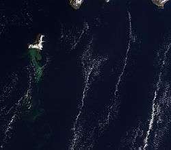
Three webcams in La Restinga were focussed on the 'stain', the area of the sea under which the eruption was taking place.[8] Several separate plumes of material, aligned N-S, were visible from the air, showing that the eruption was of a fissure type.
The main volcano on the island, Tanganasoga, underwent rapid inflation and increased carbon dioxide gas emissions, which were a cause for concern.[9] On 24 November there were various reports of a sulphurous smell in the El Golfo area of the island.
On 27 November the coast guard vessel Salvamar Adhara collected some pumice clasts, colloquially nicknamed 'floating lava bombs' or 'lava balloons', some of many that had been ejected by the underwater eruption and floated to the surface of the sea before sinking again.[10][11][12]
In the following days, three scientific and seismic survey vessels studied the area: Sarmiento da Gamboa (bathymetry, gravity and mapping seismic profiles), Ramon Margalef (multibeam bathymetric survey, sediment sampling and the acquisition of echograms of the water column) and Cornide de Saavedra (physical and chemical evolution of the volcano stain).[10]
The depth of the volcano beneath the surface of the water was estimated at 60 metres in early December;[13] after detailed bathymetric surveys the highest point was placed at between 150m and 180m below the sea surface.[10] By late February 2012 the depth of the highest point was 100m below sea level.[10]
On 21 December 2011 it was suggested that the eruption was subsiding, as the harmonic tremors and earthquakes are decreasing in frequency;[14] however, in early January 2012 the earthquakes were increasing in frequency and the area of the eruption appeared to be increasing, with a wider area of sea producing the steaming pumice clasts, steam and general "jacuzzi" activity.[10] By late February 2012 a decrease in seismicity, deformation and gas release was noted.[10] In early March the authorities on El Hierro declared the eruption to be over; this was questioned by some vulcanologists. The webcams were taken down. In mid-April 2012 the top of the cone was measured at 86 metres below the surface of the sea.[15] As of June 2012, passive degassing continues at the Restinga underwater vent.
Climatic impacts of the October 2011 to March 2012 El Hierro submarine volcanic eruption was reported by Yim (2013).
Reference Yim, W. (2013). El Hierro: climatic impacts of the October 2011 to March 2012 El Hierro submarine volcanic eruption. Imperial Engineer, issue number 19, 12-13.
June 2012 activity

Between 2 and 4 June 2012 seismic activity on the island again picked up, with small earthquake swarms indicating deep-seated magma movement below the island. A period of quiet followed, with another period of earthquake swarms starting on 14 June, and still continuing. Plotting of the earthquake epicentres showed that the magma was moving southwestwards across the central part of the island and under the area of the sea near the El Julan – La Dehesa area of the island i.e. to the northwest of the La Restinga vent of 2011-2012. Deformation of the island continued at a faster rate than that observed prior to the October 2011 eruption.[10][16] Sensors measured that inflation of 4 cm height had taken place in the three days up to 27 June - a very fast rate of deformation.
September 2012 activity
In mid September 2012 earthquake activity increased again.[10][17]
Source of the magma
For the October 2011-March 2012 eruption, and the two phases of subsequent earthquake activity, plotting has shown that in all cases the magma rose under the area of Tanganasoga. In the eruption it worked south-eastwards to near La Restinga; in the February upsurge in activity followed the same path. Modelling of ground deformation measured with radar interferometry confirmed two shallow magma reservoirs, consistent with the migration of earthquakes epicenters.[18] The June 2012 earthquake activity had the magma moving to the west of the island, and the current (mid September) earthquake activity has shown that the magma moving south from Tanganasoga.
Notes
- 1 2 3 "Canary Islands Government Monitors El Hierro Earthquake Swarm". 24 July 2011.
- ↑ "El Hierro Volcano eruption (Canary Islands) : Part 1 - July 28 until September 7, 2011". 28 July 2011.
- 1 2 "El enjambre sísmico de El Hierro suma más de 4.000 terremotos" (in Spanish). 25 August 2011.
- ↑ Tom Worden (2011-09-28). "Evacuation of smallest Canary Island begins after earthquake 'swarm' sparks fears of volcanic eruption". Daily Mail. London. Retrieved 2011-09-29.
- ↑ "Seismogram for El Hierro". Retrieved 10 October 2011.
- ↑ http://www.elpais.com/articulo/sociedad/Instituto/Geografico/Nacional/apunta/erupcion/submarina/marcha/Hierro/elpepusoc/20111010elpepusoc_5/Tes
- ↑ Chris Parsons (2011-11-07). "Ready to blow? Homes evacuated on Canary Island as underwater volcano spews molten rock 60ft into the air". Daily Mail. London. Retrieved 2011-11-25.
- ↑ http://earthquake-report.com/2011/11/12/32535/
- ↑ http://volcanocafe.wordpress.com/2011/11/22/tanganasoga-vulcano-inflation/
- 1 2 3 4 5 6 7 8 http://earthquake-report.com/2011/09/25/el-hierro-canary-islands-spain-volcanic-risk-alert-increased-to-yellow/
- ↑ Klemetti, Erik (28 November 2011). "Mixing Magmas at the Ongoing El Hierro Eruption". Wired.
- ↑ http://onlinelibrary.wiley.com/doi/10.1029/2012GL052675/pdf
- ↑ "Canary Island volcano: A new island in the making?". BBC News. 4 December 2011.
- ↑ http://earthobservatory.nasa.gov/IOTD/view.php?id=76717&src=eoa-iotd
- ↑ http://earthquake-report.com/2012/05/19/el-hierro-volcano-eruption-canary-islands-part-40-april-11-until-april-21/
- ↑ Klemetti, Erik (25 June 2012). "Signs of Revived Activity at El Hierro in the Canary Islands". Wired.
- ↑ Klemetti, Erik (16 September 2012). "Potential Magmatic Intrusion Underway at El Hierro?". Wired.
- ↑ "Gonzalez, P.J., S.V. Samsonov, S. Pepe, K.F. Tiampo, P. Tizzani, F. Casu, J. Fernandez, A.G. Camacho, and E. Sansosti (2013), Magma storage and migration associated with the 2011–2012 El Hierro eruption: Implications for crustal magmatic systems at oceanic island volcanoes, J. Geophys. Res. Solid Earth, 118, 4361–4377, doi:10.1002/jgrb.50289.".
External links
- Daily updated webpage on the eruption
- Blog by a volcanologist (academic) about the eruption
- Site with regularly updated information
- Photo of the floating lava bombs on 27 November
- "The 2011 submarine volcanic eruption in El Hierro (Canary Islands)" by Juan Carlos Carracedo, Francisco Pérez Torrado, Alejandro Rodríguez González, Vicente Soler, José Luis Fernández Turiel, Valentin R. Troll and Sebastian Wiesmaier
- The ongoing volcanic eruption of El Hierro, Canary Islands
- "Xenopumices from the 2011-2012 submarine eruption of El Hierro (Canary Islands, Spain): Constraints on the plumbing system and magma ascent" GEOPHYSICAL RESEARCH LETTERS, VOL. 39, L17302, doi:10.1029/2012GL052675, 2012 (PDF)
- NASA Earth Observatory image and article on the eruption
- Instituto Vulcanológico de Canarias page with many photos (in Spanish)
- 4D model of earthquake swarm July to September 2011
- Global Volcanism Program, Smithsonian Institution
- Daily Mail article with photographs
- James M. Day, e.a.: Evidence for distinct proportions of subducted oceanic crust and lithosphere in HIMU-type mantle beneath El Hierro and La Palma, Canary Islands, 2010 (Science Direct, PDF)
- Martin J.R. Gee, e.a.: Landslides and evolution of El Hierro in the Canary Islands, Marine Geology 177 (2001), 271-93 (PDF)
- M. R. Gee, e.a.: Offshore continuation of volcanic rift zones, El Hierro, Canary Islands, Journal of Volcanology and Geothermal Research, 105 (2001), 107 - 119 (PDF)
- F.G. MONTESINOS: New study of the local gravity field of El Hierro (Canary Islands), Física de la Tierra, 2005, 17, 113-127 (PDF)
- Longpre, M.; Troll, V.; Hansteen, T. H.; Anderson, E.: Ankaramitic Lavas and Clinopyroxene Megacrysts From the Tanganasoga Volcano, El Hierro Island (Canary Archipelago), American Geophysical Union, Fall Meeting 2009, abstract #V51A-1662, Publication Date: 12/2009 (Abstract)
- N. A. Stroncik, e.a.: The magmatic plumbing system beneath El Hierro (Canary Islands): constraints from phenocrysts and naturally quenched basaltic glasses in submarine rocks, Contrib Mineral Petrol (2009) 157:593–607, DOI 10.1007/s00410-008-0354-5 (PDF)
- J. J. Hernandez, e.a.: Volcanic caves in El Hierro island, Canary Islands, Spain (PDF)
- J. de Nuez Pestana, e.a.: Geology and volcanology of La Palma and El Hierro, western Canaries , Estudios geológicos, Vol. 57 no.56, 175-273 (Abstract)
- Serie Sísmica de El Hierro, Grupo de Investigación de Ingeniería Sísmica, Universidad de Madrid, act. 29.9.2011 (Spanish)
- Photo gallery of the El Hierro volcanic eruption. Instituto Geográfico Nacional, Madrid. Retrieved 2012-12-14.
Coordinates: 27°36′55″N 18°01′35″W / 27.61528°N 18.02639°W