1987 Pacific typhoon season
| |
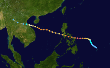
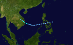
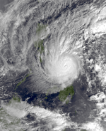
| Season summary map |
| First system formed |
January 7, 1987 |
| Last system dissipated |
December 20, 1987 |
| Strongest storm1 |
Betty – 890 hPa (mbar), 205 km/h (125 mph) (10-minute sustained) |
| Total depressions |
26 |
| Total storms |
25 |
| Typhoons |
17 |
| Super typhoons |
6 |
| Total fatalities |
> 1,438 |
| Total damage |
> $402 million (1987 USD) |
| 1Strongest storm is determined by lowest pressure |
Pacific typhoon seasons
1985, 1986, 1987, 1988, 1989 |
The 1987 Pacific typhoon season has no official bounds; it ran year-round in 1987, but most tropical cyclones tend to form in the northwestern Pacific Ocean between May and November.[1] These dates conventionally delimit the period of each year when most tropical cyclones form in the northwestern Pacific Ocean. Tropical Storms formed in the entire west pacific basin were assigned a name by the Joint Typhoon Warning Center. Tropical depressions that enter or form in the Philippine area of responsibility are assigned a name by the Philippine Atmospheric, Geophysical and Astronomical Services Administration or PAGASA. This can often result in the same storm having two names.
A total of 25 tropical cyclones formed this year in the Western Pacific, of which 24 became tropical storms. Of the 24, 17 storms reached typhoon intensity, of which 6 reached super typhoon strength.
Storms
A total of 25 tropical cyclones formed this year in the Western Pacific, of which 24 became tropical storms. Of the 24, 17 storms reached typhoon intensity, of which 6 reached super typhoon strength.
Typhoon Orchid (Auring)
| Typhoon (JMA) |
| Category 2 typhoon (SSHWS) |
|
|
| Duration |
January 7 – January 14 |
| Peak intensity |
165 km/h (105 mph) (10-min) 955 hPa (mbar) |
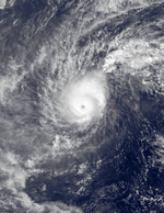
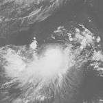
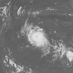
On January 3, a small and persistent area of thunderstorms near the International Dateline was first detected.[2] During the next few days, it slowly increased in organization and thunderstorm activity after which a small and ragged central dense overcast formed and upper level outflow improved.[2] A Tropical Cyclone Formation Alert (TCFA) was issued late on January 7 for the disturbance.[2] The JTWC then issued their first warning on Tropical Depression 01W during the afternoon of January 7.[2] The next morning, on January 8, an aircraft reconnaissance mission reported tropical storm–winds and the depression was upgraded to a tropical storm and named Orchid.[2] Orchid continued to gradually strengthen until it reached its peak intensity of 110 mph (175 km/h) on January 11 as a small typhoon.[2] After reaching peak intensity, Orchid weakened rather quickly and by January 14, it had degenerated into an area of low pressure.[2]
Orchid caused "extensive damage" on Ulithi Atoll but no deaths were reported.[2] In the wake of the typhoon, the United States Federal Emergency Management Agency declared parts of the Federated States of Micronesia as a disaster area.[3]
Tropical Storm Percy
| Tropical storm (JMA) |
| Tropical storm (SSHWS) |
|
|
| Duration |
April 3 – April 15 |
| Peak intensity |
85 km/h (50 mph) (10-min) 1000 hPa (mbar) |
Tropical Storm Ruth
| Tropical storm (JMA) |
| Tropical storm (SSHWS) |
|
|
| Duration |
June 17 – June 19 |
| Peak intensity |
85 km/h (50 mph) (10-min) 992 hPa (mbar) |
Typhoon Sperry (Bebeng)
| Typhoon (JMA) |
| Category 1 typhoon (SSHWS) |
|
|
| Duration |
June 26 – July 1 |
| Peak intensity |
120 km/h (75 mph) (10-min) 980 hPa (mbar) |
Typhoon Thelma (Katring)
| Typhoon (JMA) |
| Category 4 super typhoon (SSHWS) |
|
|
| Duration |
July 6 – July 16 |
| Peak intensity |
185 km/h (115 mph) (10-min) 915 hPa (mbar) |
Typhoon Thelma, which formed on July 6, steadily intensified to a peak of 150 mph (240 km/h) winds on July 11 while east of the northern Philippines. It turned sharply northward in response to a break in the ridge, slowly weakening as it remained east of any major landmass. On July 15, 80 mph (130 km/h) Typhoon Thelma hit the south coast of South Korea, causing massive flooding amounting to 123 casualties (with 212 missing) and $124 million (1987 USD) in crop and structural damage. In addition, Thelma brought heavy wind and rough seas to the Philippines that killed 12 people.[4]
Severe Tropical Storm Vernon (Diding)
| Severe tropical storm (JMA) |
| Category 1 typhoon (SSHWS) |
|
|
| Duration |
July 15 – July 22 |
| Peak intensity |
110 km/h (70 mph) (10-min) 985 hPa (mbar) |
Typhoon Wynne (Gening)
| Typhoon (JMA) |
| Category 4 typhoon (SSHWS) |
|
|
| Duration |
July 18 – August 1 |
| Peak intensity |
185 km/h (115 mph) (10-min) 920 hPa (mbar) |
This cyclone was the fifth typhoon of 1987. It became the third midget of the year and maintained an eye for six days. The initial disturbance formed east of the International Dateline on July 20. As it moved west-northwest, it organized into a tropical depression. It became a typhoon on July 23 and passed over the northern Marianas island of Alamagan. By July 26, Wynne reached its maximum intensity of 145 mph (230 km/h). As it rounded the western periphery of the subtropical ridge, the cyclone became sheared from the north and became an exposed center. Even so, it maintained typhoon intensity until July 29. Recurving east of Honshū, Wynne continued to weaken, becoming an extratropical cyclone by the afternoon of July 31.[5]
Typhoon Alex (Etang)
| Typhoon (JMA) |
| Category 1 typhoon (SSHWS) |
|
|
| Duration |
July 21 – July 30 |
| Peak intensity |
120 km/h (75 mph) (10-min) 970 hPa (mbar) |
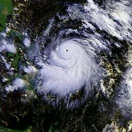
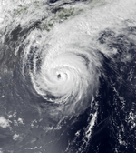
Typhoon Betty (Herming)
| Typhoon (JMA) |
| Category 5 super typhoon (SSHWS) |
|
|
| Duration |
August 7 – August 17 |
| Peak intensity |
205 km/h (125 mph) (10-min) 890 hPa (mbar) |
The monsoon trough spawned a tropical depression on August 7 while around 500 miles (800 km) east of the Philippines. It drifted northwestward, becoming a tropical storm on August 9 and a typhoon on August 10. Betty turned westward, where it rapidly intensified to a 160 mph (260 km/h) super typhoon on August 11. It weakened slightly to a 155 mph (249 km/h) super typhoon before hitting the central Philippines on the 12th. Betty weakened to a 105 mph (169 km/h) typhoon over the country, but restrengthened to a 135 mph (217 km/h) typhoon over the South China Sea. Land interaction weakened Betty to a minimal typhoon before it hit central Vietnam on August 16.[6] Betty caused 94 deaths, with damage from flooding adding up to 2 billion Philippine Pesos.[7]
Typhoon Cary (Ising)
| Typhoon (JMA) |
| Category 2 typhoon (SSHWS) |
|
|
| Duration |
August 7 – August 24 |
| Peak intensity |
140 km/h (85 mph) (10-min) 960 hPa (mbar) |
August Tropical Storm
| Tropical storm (JMA) |
|
|
| Duration |
August 10 – August 13 |
| Peak intensity |
65 km/h (40 mph) (10-min) 1006 hPa (mbar) |
Typhoon Dinah (Luding)
| Typhoon (JMA) |
| Category 4 super typhoon (SSHWS) |
|
|
| Duration |
August 19 – August 31 |
| Peak intensity |
185 km/h (115 mph) (10-min) 915 hPa (mbar) |
Tropical Storm Ed
| Tropical storm (SSHWS) |
|
|
| Duration |
August 20 – August 28 |
| Peak intensity |
65 km/h (40 mph) (1-min) 1000 hPa (mbar) |
Typhoon Freda
| Typhoon (JMA) |
| Category 4 typhoon (SSHWS) |
|
|
| Duration |
September 3 – September 17 |
| Peak intensity |
195 km/h (120 mph) (10-min) 915 hPa (mbar) |
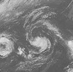
The middle cyclone of a set of triplets, Freda stalled briefly after Gerald dissipated and Holly swung around its northeast side, with Freda eventually following Holly out of sea by recurving east of Japan.[8]
Typhoon Gerald (Neneng)
| Typhoon (JMA) |
| Category 3 typhoon (SSHWS) |
|
|
| Duration |
September 4 – September 11 |
| Peak intensity |
150 km/h (90 mph) (10-min) 950 hPa (mbar) |
On September 4 a tropical depression formed east of Luzon from the monsoon trough. It remained embedded within the trough, and moved erratically, drifting northward to become a tropical storm late on the 4th. Gerald turned more to the northwest, reached typhoon strength on the 7th, and continued to intensify to a peak of 120 mph (190 km/h) on the 8th. It passed south of Taiwan, disrupting the circulation and weakening it as it continued to the west-northwest. Gerald hit southeast China as a 65 mph (105 km/h) tropical storm on the 10th, and dissipated the next day. Mudslides and torrential flooding up to 16 inches (410 mm) in some locations resulted in $131 million in damage (1987 USD) and 127 fatalities.[9]
Typhoon Holly
| Typhoon (JMA) |
| Category 5 super typhoon (SSHWS) |
|
|
| Duration |
September 1 – September 15 |
| Peak intensity |
205 km/h (125 mph) (10-min) 900 hPa (mbar) |
The eastern member of a set of triplets, Holly recurved well out to sea, not affecting mainland Asia.[10]
Typhoon Ian
| Typhoon (JMA) |
| Category 3 typhoon (SSHWS) |
|
|
| Duration |
September 22 – October 4 |
| Peak intensity |
140 km/h (85 mph) (10-min) 955 hPa (mbar) |
Tropical Depression 17W
| Tropical depression (SSHWS) |
|
|
| Duration |
September 24 – September 26 |
| Peak intensity |
55 km/h (35 mph) (1-min) 1000 hPa (mbar) |
Typhoon Peke
| Typhoon (JMA) |
| Category 3 typhoon (SSHWS) |
|
|
| Duration |
September 28 (Entered basin) – October 3 |
| Peak intensity |
150 km/h (90 mph) (10-min) 950 hPa (mbar) |
Tropical Storm June
| Tropical storm (JMA) |
| Tropical storm (SSHWS) |
|
|
| Duration |
September 27 – October 2 |
| Peak intensity |
85 km/h (50 mph) (10-min) 992 hPa (mbar) |
Typhoon Kelly (Oniang)
| Typhoon (JMA) |
| Category 2 typhoon (SSHWS) |
|
|
| Duration |
October 9 – October 17 |
| Peak intensity |
140 km/h (85 mph) (10-min) 955 hPa (mbar) |
A tropical disturbance formed east of the southern Philippines on October 7. Moving north-northwest for much of its life cycle, the system became a tropical depression and strengthened into a tropical storm on October 11 and a typhoon on October 12. Recurving near the 26th parallel, Kelly struck southern Japan as a typhoon early on October 17 and rapidly transitioned into an extratropical cyclone later that day in the Sea of Japan. On Shikoku Island Kelly dropped 20 inches (510 mm) of rain, resulting floods and landslides killed 8 people.[11]
Typhoon Lynn (Pepang)
| Typhoon (JMA) |
| Category 5 super typhoon (SSHWS) |
|
|
| Duration |
October 14 – October 28 |
| Peak intensity |
195 km/h (120 mph) (10-min) 920 hPa (mbar) |
Typhoon Lynn, having developed from the monsoon trough on October 15 over the open ocean, rapidly intensified to a 160 mph (260 km/h) super typhoon on the 19th and 20th. It crossed through the Mariana Islands, and steadily weakened as it continued westward. Lynn passed just north of Luzon on the 23rd, and upper level winds weakened it to a tropical depression before it hit southern China on the 28th. Lynn's tight pressure gradient, in combination with a large high pressure area over China, caused heavy winds over Taiwan, resulting in the formation of torrential rains of up to 68 inches (1,700 mm) in Taipei. 42 people perished from the extreme flooding, the worst in Taiwan in 40 years.[12]
Tropical Storm Maury (Rosing)
| Tropical storm (JMA) |
| Tropical storm (SSHWS) |
|
|
| Duration |
November 7 – November 19 |
| Peak intensity |
85 km/h (50 mph) (10-min) 995 hPa (mbar) |
Typhoon Nina (Sisang)
| Typhoon (JMA) |
| Category 5 super typhoon (SSHWS) |
|
|
| Duration |
November 16 – November 30 |
| Peak intensity |
165 km/h (105 mph) (10-min) 930 hPa (mbar) |
Tropical Storm Nina, which began its life on November 16 in the eastern portion of the Western Pacific ocean, slowly strengthened to a typhoon on the 21st. It continued to strengthen as it passed through the Caroline Islands, and reached super typhoon strength on the 25th just east of the Philippines. Nina continued to intensify, and reached a peak of 165 mph (266 km/h) winds just before hitting the central Philippines on the evening of the 25th. Nina exited the archipelago the next day as a 105 mph (169 km/h) typhoon. Nina briefly re-strengthened to a 115 mph (185 km/h) typhoon before turning to the north. The typhoon briefly threatened Hong Kong on the 28th, but vertical shear caused the low level circulation and upper level circulation to separate, leaving a rapidly weakening Nina to turn southward over the South China Sea. The storm finally dissipated on the 30th, but not after causing 1,036 casualties and extensive crop damage on its path of 1.12 billion Philippine Pesos (1987 pesos).[13]
Tropical Storm Ogden
| Tropical storm (SSHWS) |
|
|
| Duration |
November 20 – November 25 |
| Peak intensity |
85 km/h (50 mph) (1-min) 995 hPa (mbar) |
Typhoon Phyllis (Trining)
| Typhoon (JMA) |
| Category 3 typhoon (SSHWS) |
|
|
| Duration |
December 9 – December 20 |
| Peak intensity |
140 km/h (85 mph) (10-min) 960 hPa (mbar) |
Storm names
During the season 23 named tropical cyclones developed in the Western Pacific and were named by the Joint Typhoon Warning Center, when it was determined that they had become tropical storms. These names were contributed to a revised list from 1979.
| Orchid | Percy | Ruth | Sperry | Thelma | Vernon | Wynne | Alex | Betty | Cary | Dinah | Ed |
| Freda | Gerald | Holly | Ian | June | Kelly | Lynn | Maury | Nina | Odgen | Phyllis |
Philippines
| Auring | Bebeng | Karing | Diding | Etang |
| Gening | Herming | Ising | Luding | Mameng |
| Neneng | Oniang | Pepang | Rosing | Sisang |
| Trining | Uring (unused) | Warling (unused) | Yayang (unused) | |
| Auxiliary list |
| | | | | Ading (unused) |
| Barang (unused) | Krising (unused) | Dadang (unused) | Erling (unused) | Goying (unused) |
The Philippine Atmospheric, Geophysical and Astronomical Services Administration uses its own naming scheme for tropical cyclones in their area of responsibility. PAGASA assigns names to tropical depressions that form within their area of responsibility and any tropical cyclone that might move into their area of responsibility. Should the list of names for a given year prove to be insufficient, names are taken from an auxiliary list, the first 6 of which are published each year before the season starts. Names not retired from this list will be used again in the 1991 season. This is the same list used for the 1983 season. PAGASA uses its own naming scheme that starts in the Filipino alphabet, with names of Filipino female names ending with "ng" (A, B, K, D, etc.). Names that were not assigned/going to use are marked in gray.
Retirement
Because Typhoons Herming and Sisang made extensive damage and death toll within the Philippines, the PAGASA later retired the names Herming and Sisang. Replaced names were selected as Helming and Sendang for the 1991 season.
See also
References
External links