1971 Pacific hurricane season
| |
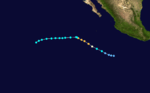
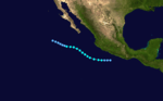
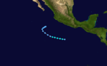
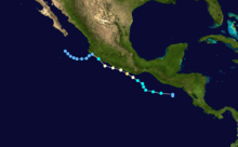
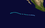
| Season summary map |
| First system formed |
May 21, 1971 |
| Last system dissipated |
November 29, 1971 |
| Strongest storm1 |
Olivia – 948 mbar (hPa) (27.99 inHg), 115 mph (185 km/h) (1-minute sustained) |
| Total depressions |
22 |
| Total storms |
18 |
| Hurricanes |
12 |
| Major hurricanes (Cat. 3+) |
6 |
| Total fatalities |
52 |
| Total damage |
Unknown |
| 1Strongest storm is determined by lowest pressure |
Pacific hurricane seasons
1969, 1970, 1971, 1972, 1973 |
The 1971 Pacific hurricane season began on May 15, 1971, in the east Pacific, and on June 1, 1971, in the central Pacific. It ended on November 30, 1971. These dates conventionally delimit the period of time when tropical cyclones form in the east Pacific Ocean.
The 1971 season was above average with 18 named storms. Twelve hurricanes formed, of which six became major hurricanes by reaching Category 3 or higher on the Saffir-Simpson Hurricane Scale. At the time, this was a record number of storms. This season had six landfalls (Agatha, Bridget, Katrina, Lily, Olivia and Priscilla), the highest number of landfalling Pacific tropical cyclones in one season.
Storms
Hurricane Agatha
| Category 2 hurricane (SSHWS) |
|
|
| Duration |
May 21 – May 25 |
| Peak intensity |
100 mph (155 km/h) (1-min) ≤ 972 mbar (hPa) |
On May 21, an area of low pressure developed in the very warm waters south of Tehuantepec, Mexico. Later that day, satellite images showed increasing circulation and Tropical Storm Agatha developed shortly after. Agatha continued moving to the west-northwest parallel to the Mexican coastline and strengthened into a hurricane on May 22. A U.S. Air Force weather reconnaissance aircraft flew into Agatha and found an eye and strong bands. The next day, a reconnaissance plane found winds of 85 to 90 mph (140 to 150 km/h). On May 24, a ship reported winds of 100 mph (160 km/h). Agatha made landfall as a Category 2 hurricane on the Saffir-Simpson hurricane scale within 45 mi (75 km) of Zihuatanejo, Mexico.
The village of Playa Azul was hard hit by the storm. Up to half of the village's homes were destroyed. Also, much of the banana, mango, and coconut crop was destroyed.
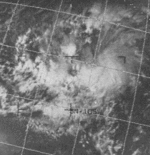
Hurricane Bridget
| Category 2 hurricane (SSHWS) |
|
|
| Duration |
June 14 – June 20 |
| Peak intensity |
100 mph (155 km/h) (1-min) 998 mbar (hPa) |
A tropical disturbance near El Salvador remained unorganized until June 12. The area of convection started to drift west-northwestward and strengthened into Tropical Depression Two-E. On June 15, the Tropical Depression further intensified into Tropical storm status and was named Bridget, the second tropical storm of the season. Tropical Storm Bridget moved across the Gulf of Tehuantepec which was favorable for Development. On June 16, Bridget continued intensifying and satellite imagery and ship report data confirmed that Bridget had strengthened into a hurricane. Hurricane Bridget continued moving west-northwest along the west coast of Mexico and came within 35 to 45 mi (55 to 75 km) of Acapulco on June 17. Bridget later made landfall as a Tropical Storm about 100 mi (155 km) southeast of Manzanillo, Mexico. However, the Tropical Depression Re-entered open waters and dissipated on June 20.
Bridget was the worst hurricane to hit Acapulco in over 25 years; the last strong hurricane to impact Acapulco to a greater extent was the 1943 Mazatlan Hurricane, which made landfall as a Category 3 hurricane and caused $56 million (1971 USD; $328 million 2016 USD) in damage. Hurricane Bridget's storm surge caused flooding in the bay and damaged waterfront and beach facilities. Rough weather and violent seas also sank 20 boats plus a flagship of the Mexican Navy.
Hurricane Carlotta
| Category 1 hurricane (SSHWS) |
|
|
| Duration |
July 2 – July 8 |
| Peak intensity |
85 mph (140 km/h) (1-min) ≤ 980 mbar (hPa) |
On July 1 an area of weather developed about 115 mi (185 km) east of Clipperton Island. On July 2 the area of thunderstorms strengthened into Tropical Storm Carlotta. An Air Force reconnaissance aircraft flew into Carlotta on July 4 and found a system with a well-defined eye and good outflow, but winds only supported a tropical storm. Another reconnaissance plane found winds that were near hurricane strength on July 4. In post-season analysis, it was discovered that Carlotta was a hurricane for 24 hours on July 3 and 4. Later that day, Carlotta started weakening after moving into a less favorable environment. The storm continued to weaken until dissipating on July 8.
Carlotta stayed over open waters during its entire life and no land was affected.
Hurricane Denise
| Category 4 hurricane (SSHWS) |
|
|
| Duration |
July 2 – July 14 |
| Peak intensity |
140 mph (220 km/h) (1-min) ≤ 951 mbar (hPa) |
On July 2 an area of weather got better organized about 865 mi (1390 km) east of then Tropical Storm Carlotta. On July 4 satellite imagery indicated that the system had strengthened into Tropical Storm Denise and later into Hurricane Denise on July 6. The system continued to move west and on July 7, U.S. Air Force weather reconnaissance plane found a more organized system with sustained winds estimated to be 90 mph (150 km/h) with a minimum central pressure of 963 mbar (hPa; 28.4 inHg). By July 8, the system had sustained one-minute winds of 125 mph (205 km/h) and a minimum central pressure of 951 mbar (hPa; 28.1 inHg). Denise reached a peak intensity of 140 mph (220 km/h), a Category 4 on the Saffir-Simpson Hurricane Scale early on July 9, but then started to weaken.
Denise had started a northwest movement towards Hawaii. A reconnaissance aircraft found surface winds of approximately 115 mph (185 mph) on July 9. Soon after, the eyewall started to dissipate, most likely because of cooler inflow. Over the next 48 hours, the system continued to weaken into a tropical storm. On July 13 the system was approaching the Hawaiian Islands, but a reconnaissance flight only found winds that were barely tropical storm strength. What was left of the storm quickly weakened and Denise became a remnant low.
The remnants of Denise moved south of the Hawaiian Islands, but still brought beneficial rains that caused some minor flooding.[1]
Tropical Storm Eleanor
| Tropical storm (SSHWS) |
|
|
| Duration |
July 7 – July 11 |
| Peak intensity |
60 mph (95 km/h) (1-min) ≤ 1007 mbar (hPa) |
Eleanor was a short-lived, weak tropical storm that stayed well out to sea. On July 7, a tropical depression formed east-southeast of the weakening Carlotta and west of the strengthening Denise. By July 8, satellite imagery showed that the depression had strengthened into a tropical storm. Eleanor strengthened over the next 24 hours to a top strength of 60 mph (95 km/h). On July 10, a U.S. Air Force weather reconnaissance plane found a weakening system and the next day the storm was a dissipating depression moving toward the west-southwest.
Hurricane Francene
| Category 3 hurricane (SSHWS) |
|
|
| Duration |
July 18 – July 23 |
| Peak intensity |
115 mph (185 km/h) (1-min) ≤ 991 mbar (hPa) |
An area of enhanced shower activity and low pressure circulation developed a couple hundred miles off the coast of Mexico. On July 18 a tropical depression had formed and on July 19 the system strengthened into Tropical Storm Francene. Francene underwent rapid deepening into a Category 3 hurricane on the Saffir-Simpson Hurricane Scale. However, because of Francene's increasing size, the storm starting pulling in cool surface air which caused weakening. By July 20, Francene had weakened into a tropical storm. Francene continued to weaken over the next 24 hours and was barley a tropical storm by the morning of July 22. That afternoon, Francene began to strengthen once again but it was short-lived. By July 23, the surface circulation had disappeared and Francene was no longer a tropical cyclone. Francene stayed over open water and did not affect land.
Tropical Storm Georgette
| Tropical storm (SSHWS) |
|
|
| Duration |
July 20 – July 27 |
| Peak intensity |
60 mph (95 km/h) (1-min) 990 mbar (hPa) |
A tropical depression formed to the east of Hurricane Francene on July 20. A reconnaissance flight found a poorly organized tropical storm with winds of 50 mph (80 km/h) on July 23. Georgette reached a peak intensity of 60 mph (97 km/h) the next day. Ships to the north of Georgette reported weak tropical storm force winds. By July 26 the storm began to weaken rapidly before dissipating the next day.
Hurricane Hilary
| Category 2 hurricane (SSHWS) |
|
|
| Duration |
July 26 – August 7 |
| Peak intensity |
100 mph (155 km/h) (1-min) ≤ 964 mbar (hPa) |
Tropical Storm Hilary developed about 115 mi (185 km) west of Clipperton Island on July 26. Hilary strengthened quickly into a hurricane by July 28 and a recon plane found surface winds of 90 mph (140 km/h) and noted a well-defined eye. The hurricane would peak as a category 2 with sustained winds of 100 mph (160 km/h) on July 30.[2] Hilary weakened slightly as its motion became erratic across the tropical Pacific Ocean. By August 1 the hurricane turned to the northwest towards cooler waters. Hilary weakened into a tropical storm on August 3 after being at hurricane strength for a week.[2] Steady weakening continued over the next four days before dissipating in the Central Pacific.
Hurricane Ilsa
| Category 3 hurricane (SSHWS) |
|
|
| Duration |
July 31 – August 8 |
| Peak intensity |
115 mph (185 km/h) (1-min) ≤ 978 mbar (hPa) |
Hurricane Ilsa formed on July 31 to the south of the Mexican coast. It gradually strengthened into a tropical storm and a hurricane. Ilsa peaked as a Category 3 hurricane before heading further out to sea and weakening. Hurricane Ilsa dissipated on August 8.
Tropical Storm Jewel
| Tropical storm (SSHWS) |
|
|
| Duration |
August 6 – August 11 |
| Peak intensity |
70 mph (110 km/h) (1-min) 993 mbar (hPa) |
Tropical Storm Jewel formed near Mexico on August 6. Heading out to sea, it strengthened into a 70 mph (112.63 km/h) tropical storm. It dissipated on August 11.
Tropical Storm Katrina
| Tropical storm (SSHWS) |
|
|
| Duration |
August 8 – August 13 |
| Peak intensity |
65 mph (100 km/h) (1-min) 1008 mbar (hPa) |
Katrina was a very small storm. Katrina brushed Baja California Sur and made landfall in the Mexican state of Sonora as a tropical storm. It dissipated on August 13. Rain from Katrina's remnants ruined crops, destroyed railroad trestles, and washed away three bridges.
Hurricane Lily
| Category 1 hurricane (SSHWS) |
|
|
| Duration |
August 28 – September 1 |
| Peak intensity |
85 mph (140 km/h) (1-min) 978 mbar (hPa) |
The remnants of Tropical Storm Chloe in the Atlantic formed into Tropical Depression Twelve on August 28. Twelve continued northeast and intensified into a tropical storm and was thus assigned the name Lily. Lily turned north-northwest.Rapid intensification occurred and Lily developed an eye. Lily peaked with one-minute sustained winds of 85 mph and a pressure of 978mb. Lily made landfall soon after. Once over land, Lily fell below tropical storm intensity. Then the hurricane turned northwest and dissipated soon after.
Hurricane Monica
| Category 3 hurricane (SSHWS) |
|
|
| Duration |
August 29 – September 5 |
| Peak intensity |
115 mph (185 km/h) (1-min) ≤ 1005 mbar (hPa) |
Monica was a Category 3 hurricane which did not affect land.
Hurricane Nanette
| Category 2 hurricane (SSHWS) |
|
|
| Duration |
September 3 – September 9 |
| Peak intensity |
100 mph (155 km/h) (1-min) ≤ 984 mbar (hPa) |
Hurricane Nanette threatened southern Baja California but turned west before making landfall.
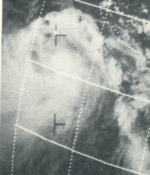
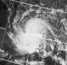
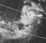
Hurricane Olivia
| Category 3 hurricane (SSHWS) |
|
|
| Duration |
September 20 – October 1 |
| Peak intensity |
115 mph (185 km/h) (1-min) 948 mbar (hPa) |
Olivia was a continuation of Atlantic Hurricane Irene. Olivia eventually strengthened into a Category 3 hurricane before recurving and making landfall in Baja California as a depression. The remnants of Olivia continued north into California, where they brought rain.
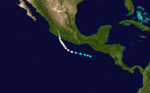
Hurricane Priscilla
| Category 3 hurricane (SSHWS) |
|
|
| Duration |
October 6 – October 13 |
| Peak intensity |
125 mph (205 km/h) (1-min) 951 mbar (hPa) |
Priscilla made landfall south of Mazatlán as a tropical storm. It had weakened significantly before landfall, having once been a strong Category 3 hurricane. Priscilla destroyed roughly 36,000 acres of corn, tomatoes, peppers, bananas, and cotton, resulting in $3.12 million in losses. Heavy rains inundated 30 towns in Nayarit, damaging roads and two major thoroughfares; road damage totaled $544,000.[3]
Tropical Storm Ramona
| Tropical storm (SSHWS) |
|
|
| Duration |
October 28 – October 31 |
| Peak intensity |
60 mph (95 km/h) (1-min) 1009 mbar (hPa) |
Ramona formed on October 28, it quickly strengthened into a tropical storm. It later weakened back to a tropical depression. Before dissipation, it made a sharp turn to the north-northeast. It had dissipated on October 31.
Tropical Storm Sharon
| Tropical storm (SSHWS) |
|
|
| Duration |
November 25 – November 29 |
| Peak intensity |
40 mph (65 km/h) (1-min) ≤ 1009 mbar (hPa) |
Tropical Storm Sharon was a late season tropical storm that formed a few hundred miles from Mexico on November 25. It slowly strengthened into a minimal tropical storm before unfavorable conditions caused it to dissipated on November 29.
Storm names
These names were used for storms that formed in 1971. It is the same list used in the 1967 season. A storm was named Sharon for the first time this year. No names were retired, so it was used again in the 1975 season.
- Agatha
- Bridget
- Carlotta
- Denise
- Eleanor
- Francene
- Georgette
|
- Hilary
- Ilsa
- Jewel
- Katrina
- Lily
- Monica
- Nanette
|
- Olivia
- Priscilla
- Ramona
- Sharon
- Terry (unused)
- Veronica (unused)
- Winifred (unused)
|
The central Pacific used names and numbers from the west Pacific's typhoon name list. No storms formed in the region, and thus no names were used. However, tropical disturbances that later became typhoons started forming in this area.
Season effects
This is a table of all of the storms in the 1973 Pacific hurricane season. It includes their durations, peak intensities, names, landfall(s), damages, and death totals. Deaths in parentheses are additional and indirect (an example of an indirect death would be a traffic accident), but are still storm-related. Damage and deaths include totals while the storm was extratropical or a wave or a low.
1973 Pacific hurricane statistics
Storm
name |
Dates active |
Storm category
at peak intensity |
Max 1-min
wind
mph (km/h) |
Min.
press.
(mbar) |
Areas affected |
Damage
(millions USD) |
Deaths
|
| Agatha |
May 21 – 25 |
Category 2 hurricane |
100 (155) |
972 |
Mexico |
Unknown |
0
|
| Bridget |
June 14 – 20 |
Category 2 hurricane |
100 (155) |
998 |
Mexico |
56 |
17
|
| Carlotta |
July 2 – 8 |
Category 1 hurricane |
85 (140) |
980 |
None |
None |
0
|
| Denise |
July 2 – 14 |
Category 1 hurricane |
140 (220) |
951 |
Hawaii |
None |
0
|
| Eleanor |
July 7 – 11 |
Tropical storm |
60 (95) |
1007 |
None |
None |
0
|
| Francene |
July 18 – 23 |
Category 3 hurricane |
115 (185) |
991 |
None |
None |
0
|
| Georgette |
July 20 – 27 |
Category 1 hurricane |
60 (95) |
990 |
None |
None |
0
|
| Hilary |
July 26 – August 7 |
Category 2 hurricane |
100 (155) |
964 |
None |
None |
0
|
| Ilsa |
July 31 – August 8 |
Category 3 hurricane |
115 (185) |
978 |
None |
None |
0
|
| Jewel |
August 6 – 11 |
Tropical storm |
70 (110) |
993 |
None |
None |
0
|
| Katrina |
August 8 – 13 |
Tropical storm |
65 (100) |
1008 |
Mexico |
Unknown |
0
|
| Lily |
August 28 – September 1 |
Category 1 hurricane |
85 (140) |
978 |
Mexico |
Unknown |
12-14
|
| Monica |
August 29 – September 5 |
Category 3 hurricane |
115 (185) |
1005 |
None |
None |
0
|
| Nanette |
September 3 – 9 |
Category 2 hurricane |
100 (155) |
984 |
Mexico |
None |
0
|
| Olivia |
September 20 – October 1 |
Category 3 hurricane |
115 (185) |
948 |
Nicaragua, Mexico |
Unknown |
3
|
| Priscilla |
October 6 – 13 |
Category 3 hurricane |
125 (205) |
951 |
Mexico |
3.664 |
0
|
| Ramona |
October 28 – 31 |
Tropical storm |
60 (95) |
1009 |
None |
None |
0
|
| Sharon |
November 25 – 29 |
Tropical storm |
40 (65) |
1009 |
None |
None |
0 |
| Season Aggregates |
| 22[nb 1] cyclones |
May 21 – November 29 |
| 140 (220) |
948 |
Mexico, Nicaragua |
Unknown |
52 |
See also
Notes
- ↑ There were four other tropical cyclones which never reached tropical storm strength, but due to the unavailability of their data they are not added onto this table.
References
External links
|
|---|
|
| |
|
-
 Book Book
-
 Category Category
-
 Portal Portal
-
 WikiProject WikiProject
-
 Commons Commons
|


.jpg)

.png)