1872 California-Nevada State Boundary Marker
|
1872 California-Nevada State Boundary Marker | |
|
The Nevada side of the marker | |
 | |
| Location | South side of Henness Pass Rd at the California-Nevada state line[1] |
|---|---|
| Nearest city | Verdi, Nevada |
| Coordinates | 39°31′27.8″N 120°0′6.7″W / 39.524389°N 120.001861°WCoordinates: 39°31′27.8″N 120°0′6.7″W / 39.524389°N 120.001861°W |
| Built | 1872 |
| Architect | Alexey Von Schmidt |
| NRHP Reference # | 81000387 |
| Added to NRHP | August 27, 1981 |

The 1872 California-Nevada State Boundary Marker marks the initial point for the 1872 survey delineation of the state line between California and Nevada. It is listed in the National Register of Historic Places.
History
When California attained statehood in 1850, it adopted 120 degrees west longitude as its eastern border. Between 1855 and 1900 there were six surveys to locate 120 degrees, with each locating 120 degrees of longitude differently.[2] In 1872, Alexey Von Schmidt undertook the survey of the state line. He marked his survey line with stones, wood, and iron markers; the only one who placed such markers[2] A new survey in 1893 showed that the Von Schmidt line was 1,600 to 1,800 feet west of the actual 120 degrees. However, California and Nevada both recognize the 1872 Von Schmidt survey and the 1893 survey as the state line.[2]
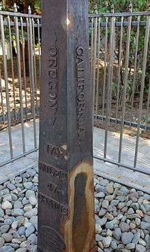
The 1872 marker near Verdi, Nevada is a four-sided cast iron pylon eight feet tall. It includes the words "CALIFORNIA" on the west face of the pylon, "NEVADA" on the east face, "1872, LONGITUDE 120 WEST OF GREENWICH, A.W. VON SCHMIDT, U.S." on the south face, and "170 MILES 47 CHAINS TO OREGON" on the north face.[2] The marker is surrounded by a chain link fence.
The marker was listed in the National Register of Historic Places because it represents the initial point of survey for the California-Nevada border, and is a remnant of this survey.
NGS gives current data for another 1872 marker that may still exist at the northeast corner of California.
See also
- List of National Historic Landmarks in Nevada
- National Register of Historic Places listings in Washoe County, Nevada
References
- ↑ Alvis Hendley. "1872 California-Nevada State Boundary Marker". NoeHill Travels in California. Archived from the original on 2009-05-14. Retrieved 2009-05-09.
- 1 2 3 4 Abbe, Donald (1979). "1872 California-Nevada State Boundary Marker" (PDF). National Register of Historic Places Inventory-Nomination Form. National Park Service. Retrieved 2009-05-09.
| Wikimedia Commons has media related to 1872 California-Nevada State Boundary Marker. |
| Topics | |
|---|---|
| Lists by states |
|
| Lists by insular areas | |
| Lists by associated states | |
| Other areas | |
| |