1257 Samalas eruption
The 1257 Samalas eruption was a major volcanic eruption of the Samalas volcano, next to Mount Rinjani on the island of Lombok, Indonesia. It left a large caldera next to Rinjani volcano, the lake Segara Anak.[1] This volcanic eruption reached a volcanic explosivity index of 7, making it one of the largest eruptions of the Holocene. The occurrence of this eruption was originally deduced from ice core information revealing a spike in sulfate deposition around the year 1257; in 2013 the source of this eruption at Samalas was definitively proven as a result of historical records from that time.
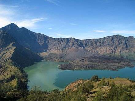
This eruption proceeded during four distinct phases, alternately creating eruption columns reaching up for tens of kilometres and pyroclastic flows that buried large parts of Lombok, destroying human habitations including the city of Pamatan. Ash from the eruption fell as far as Java. The volume of the deposits left exceeds 10 cubic kilometres (2.4 cu mi). Later activity from the volcano created additional volcanic centres in the caldera, including the present day active Barujari cone.
The eruption was witnessed by humans on Lombok, who recorded its effects on text written on palm leaves. The aerosols injected by the volcano into the atmosphere reduced the solar radiation reaching the surface of the Earth, triggering a volcanic winter and cooling lasting for several years. It is possible that the 1257 Samalas eruption helped trigger the Little Ice Age.
Geology
General geology
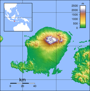
Samalas and Mount Rinjani are located in the Sunda arc, a subduction zone where the Australian plate subducts beneath the Eurasian plate. The magmas feeding Samalas and Rinjani probably form from peridotites in the mantle wedge beneath Lombok.[2] Other volcanoes in the region are Agung, Batur and Bratan on Bali, west of Lombok.[3] Before the eruption, Samalas may have been 4,200 ± 100 metres (13,780 ± 330 ft) high based on reconstructions.[4]
The oldest geological units on Lombok are of Late Oligocene age. Before 12,000 BP, volcanic activity built up the Samalas volcano. During a phase between 11,940±40 and 2,550±50 BP where the Rinjani volcano formed,[2] with this last eruption generating th Rinjani pumice with a volume of 0.3 cubic kilometres (0.072 cu mi) dense rock equivalent.[5] Another eruption took place between 5,990 ± 50 and 2,550 ± 50 BP formed the Propok Pumice with a dense rock equivalent volume of 0.1 cubic kilometres (0.024 cu mi). More eruptions are dated 11,980±40, 11,940±40 and 6250±40 BP.[6] Then, a large caldera-forming eruption destroyed Samalas volcano. Later volcanic activity occurred in the Segara Anak caldera, forming the Segara Munac, Rombogan and Barujari volcanoes.[7] Of these, most volcanic activity occurs in the Barujari volcano with eruptions in 1884, 1904, 1906, 1909, 1915, 1966, 1994, 2004 and 2009. Rombogan was active in 1944. Volcanic activity mostly consists of explosive eruptions and ash flows.[8]
The rocks of the volcano are mostly dacitic, SiO
2 contents range between 62–63% by weight.[9] Volcanic rocks in the Banda arc are mostly calc-alkaline ranging from basalt over andesite to dacite.[8] The volcano rests on crust of about 20 kilometres (12 mi) thickness, and the Wadati–Benioff zone is about 164 kilometres (102 mi) deep.[2]
Eruption
The eruption of 1257 occurred probably around September.[10] Based on the deposits of the eruption, it commenced with a first phreatic stage that deposited 3 centimetres (1.2 in) of ash over 400 square kilometres (150 sq mi) of northwest Lombok. In the subsequent first magmatic stage, a lithic rich pumice ash fell, reaching a thickness of 8 centimetres (3.1 in) both upwind on East Lombok and on Bali.[6] Subsequently, various phases of lapilli and ash falls occurred, as well as pyroclastic flows that were partially confined within the valleys on Samalas's western flank. Some ash deposits were eroded by the pyroclastic flows, generating furrow structures. Pyroclastic flows even crossed the Bali Sea, reaching the Gili Islands. This eruption phase was probably phreatomagmatic, as the deposits show evidence of interaction with water. Three pumice fallouts subsequently fell, reaching the widest extend of all deposits formed by the eruption.[11] These pumices fell as far as Sumbawa in the east, where they were up to 7 centimetres (2.8 in) thick. The formation of these pumices was followed by another stage of pyroclastic flow activity, probably caused by the collapse of the eruption column and the beginning of the formation of the caldera, where the conditions changed from column-generating to fountain-generating. These pyroclastic flows were deflected by older volcanic edifices and incinerated the vegetation. Interaction between these flows and the air triggered the formation of additional eruption clouds and secondary pyroclastic flows. Where the flows entered the sea north and east of Lombok, steam explosions generated pumice cones on the beach and additional secondary pyroclastic flows.[12] These pyroclastic flows had an on-land volume of 29 cubic kilometres (7.0 cu mi),[13] and reached thicknesses of 35 metres (115 ft) as far as 25 kilometres (16 mi) away from Samalas.[14] These phases are also known as P1 (phreatic and first magmatic phase), P2 (phreatomagmatic with pyroclastic flows), P3 (plinian) and P4 (pyroclastic flows).[15] The whole eruption lasted between 12 and 15 hours, not accounting for the first emission of pyroclastic flows (P2).[16]
Tephra from the eruption fell as far as Java, forming part of the so-called Muntilan Tephras.[12] In Lake Logung on Java it was 3 centimetres (1.2 in) thick. On Agung volcano on Bali, the deposits reached thicknesses of 12–17 centimetres (4.7–6.7 in). Most of the tephra was deposited west-southwest of Samalas.[17] Considering the thickness of Samalas tephras found at Mount Merapi, the total volume may have reached 32–39 cubic kilometres (7.7–9.4 cu mi).[18] The dispersal index of the eruption reached 7,500 square kilometres (2,900 sq mi) during the first stage and of 110,500 square kilometres (42,700 sq mi) during the third stage, implying a Plinian eruption and an ultraplinian eruption respectively.[19]
The eruption column from this eruption reached a height of 39–40 kilometres (24–25 mi) at windspeeds of 10 metres per second (33 ft/s) during the first stage (P1),[20] and 43–38 kilometres (27–24 mi) between (P3) the two stages with emission of pyroclastic flows.[16] This eruption column from was high enough that SO
2 in it and its S isotope ratio was influenced by photolysis at high altitudes.[21]
Various volumes have been estimated for the various stages of the Samalas eruption. The first stage reached a volume of 12.6–13.4 cubic kilometres (3.0–3.2 cu mi). The second phreatomagmatic phase has been estimated to have had a volume of 0.9–3.5 square kilometres (0.35–1.35 sq mi).[22] The total dense rock equivalent volume of the whole eruption is at least 40 cubic kilometres (9.6 cu mi).[19] The material erupted by the volcano had a temperature of about 1,000 °C (1,830 °F).[4] Compositionally, the material was of trachydacitic composition, containing amphibole, apatite, clinopyroxene, iron sulfide, orthopyroxene, plagioclase and titanomagnetite. It formed out of basaltic magma by fractional crystallization.[23]
The eruption has a volcanic explosivity index of 7,[24] making it one of the largest eruptions of the Holocene.[25] It was even stronger than the eruptions of Tambora in 1815 and Krakatau in 1883.[26] Other eruptions of comparable intensity are the Kurile lake eruption in the 7th millennium BC, the Mount Mazama eruption in the 6th millennium, the Minoan eruption and the Tierra Blanca Joven eruption of Ilopango in the 6th century.[25] Pumice falls with a fine graining and colour of cream from the Samalas eruption form a useful tephrochronological wikt:marker on Bali.[27] Tephra from the volcano was found in ice cores as far as 13,500 kilometres (8,400 mi) away from Samalas.[28]
The eruption left the Segara Anak caldera, which has a diametre of 6–7 kilometres (3.7–4.3 mi).[7] Within its 700–2,800 metres (2,300–9,200 ft) high walls a 200 metres (660 ft) deep crater lake formed. The Barujari cone rises 320 metres (1,050 ft) above the water of the lake and has had 15 eruptions since 1847.[5] It is possible that a crater lake already existed on Samalas before the eruption and supplied the phreatomagmatic phase thereof with 0.1–0.3 cubic kilometres (0.024–0.072 cu mi) of water; alternatively the water came from aquifers.[29] A collapse structure cuts into Rinjani's slopes facing the Samalas caldera.[4]
The eruption that formed the caldera was first recognized in 2003 and in 2004 a volume of 10 cubic kilometres (2.4 cu mi) was attributed to this eruption.[6] Early research considered that the caldera-forming eruption occurred between 1210 and 1300. In 2013, Lavigne suggested that the eruption occurred in May–October 1257, resulting in the climate changes of 1258.[7]
Research history
The existence of a major volcanic event in 1257–1258 was identified from data in ice cores as well as medieval records in the northern hemisphere.[30] The presence of sulfur deposits in the polar ice caps had already led to the conclusion that climate disturbances reported in that time were due to a volcanic event, with the global spread indicating a tropical volcano as the cause,[1] although at first a source in a volcano near Greenland had been considered.[31] The spike in sulfate concentrations was first observed in the Crete ice core,[32] associated with a deposition of rhyolitic ash.[33] These ice cores indicated a large sulfate spike around 1257, the largest in 7,000 years and twice the size of the 1815 eruption of Tambora sulfate spike,[34] although later discovered sulfate spikes around 44 and 426 BC rival its size.[35] This discovery was made in the 1980s.[31] In 2003, a dense rock equivalent volume of 200–800 cubic kilometres (48–192 cu mi) was estimated for this eruption,[36] although it was also proposed that the eruption might have been somewhat smaller and enriched in sulfur.[37] The volcano responsible could not be identified at first;[30] Tofua volcano was proposed at first but dismissed as the size of the Tofua eruption was insufficient to generate the sulfate spikes associated with the 1257 eruption.[38] Likewise, a volcanic eruption that took place in 1256 at Harrat al-Rahat next to Medina was too small to trigger these events.[39] Other proposals included the possibility that the event was triggered by the simultaneous occurrence of several eruptions.[40] Estimated caldera diametres ranged 10–30 kilometres (6.2–18.6 mi).[41]
The suggestion that Samalas/Rinjani might be the source volcano was first made in 2012, considering that the other candidate volcanoes – El Chichon and Quilotoa – did not match the chemistry of the sulfur spikes.[42] Both El Chichon, Quilotoa and Okataina were also inconsistent with the timespan and size of the eruption.[43] The conclusive link between these events and an eruption of the Samalas volcano was made in 2013 on the basis of historical records in Indonesia: the Babad Lombok, writings in Old Javanese on palm leaves,[30] written in the 13th century, induced Franck Lavigne, who had already suspected that a volcano on Lombok may be responsible, to conclude that the Samalas volcano was responsible.[31]
All houses were destroyed and swept away, floating on the sea, and many people died— Javanese text, [44]
This event occurred before the end of the 13th century.[4] The role of the Samalas eruption in the global climate events was confirmed by comparing the geochemistry of glass shards found in ice cores to that of the eruption deposits on Lombok.[1]
Climate effects
Ice cores in the northern and southern hemisphere display sulfate spikes associated with Samalas, the signal being the strongest in the southern hemisphere for the last 1000 years and being only exceeded by Laki's signal in the northern.[45] In addition, ice cores from Illimani in Bolivia contain sulfate spikes from the eruption.[46] For comparison, the 1991 eruption of Pinatubo ejected only about a tenth of Samalas's sulfur.[47] Sulfate deposition from the Samalas eruption has been noted at Svalbard,[48] and the fallout of sulfuric acid from the volcano may have directly affected peatlands in northern Sweden.[49] The amount of SO
2 released by the eruption has been estimated to be 158,000,000 ± 12,000,000 tonnes (156,000,000 ± 12,000,000 long tons; 174,000,000 ± 13,000,000 short tons);[23] the mass release was increased in comparison with the Tambora eruption due to a more effective injection of tephra into the stratosphere and/or higher sulfur contents of the Samalas magma.[50]
When large scale volcanic eruptions inject aerosols into the atmosphere, these can form stratospheric veils which reduce the amount of light reaching the surface. This reduces the temperatures on much of Earth and can cause problems in agriculture including famine. However, social effects of such events is often reduced by the resilience of humans.[51] Not all years with cold summers are linked to volcanic activity.[52] Volcanic eruptions can also deliver Br and Cl into the stratosphere where they contribute to the breakdown of ozone. While most of these elements would have been removed by scavenging by the eruption column, the quantities that have been modelled for the Samalas halogen release (227,000,000 ± 18,000,000 tonnes (223,000,000 ± 18,000,000 long tons; 250,000,000 ± 20,000,000 short tons) Cl and up to 1,300,000 ± 300,000 tonnes (1,280,000 ± 300,000 long tons; 1,430,000 ± 330,000 short tons) Br) would have reduced the stratospheric ozone.[23]
Samalas, along with the Kuwae eruption in the 1450s and Tambora in 1815 is one of the strongest cooling events in the last millennium, even more so than the peak Little Ice Age.[53] The effects of the Samalas eruption form the strongest volcanic signal in boreholes of the Urals.[54] After an early warm winter 1257/1258 – winter warming is frequently observed after tropical volcanic eruptions – resulting in the early flowering of violets according to reports from France,[55] European summers were colder after the eruption,[56] and winters were long and cold.[57] Summer cooling reached 0.69 K (1.24 °F) in the southern and 0.46 K (0.83 °F) in the northern hemisphere.[58] For comparison, the radiation forcing of Pinatubo's 1991 eruption was about one-seventh of that of the Samalas eruption.[59] Sea surface temperatures likewise decreased by 0.3–2.2 °C (0.54–3.96 °F),[60] triggering changes in the ocean circulations and the formation of deep water. Temperature changes may have lasted for a decade.[61] Precipitation and evaporation both decreased as well but the decrease of evaporation was stronger.[62]
However, the Samalas signal is only inconsistently reported from tree ring climate information,[63] and the temperature effects were likewise limited, probably because the large sulfate output altered the average size of particles and thus their radiation forcing.[64] Climate modelling indicated that the Samalas eruption may have reduced global temperatures by approximately 2 °C (3.6 °F), a value largely not replicated by proxy data. Better modelling indicated that the principal temperature anomaly occurred in 1258 and continued until 1261.[65] Some climate models tend to assume that aerosol optical depth increases linearly with the quantity of erupted sulfur and tend to thus overstimate the climate effects.[66] The possible occurrence of an El Nino before the eruption may have further reduced the cooling.[67]
The Samalas eruption together with another eruption in the 14th century set off a growth of ice caps and sea ice,[68] and glaciers in Norway advanced. It might also have modified the North Atlantic Oscillation, causing it to acquire more negative values in the subsequent decades in cooperation with a beginning decrease in solar activity as part of the Wolf minimum in the solar cycle.[69] The advances of ice after the Samalas eruption may have strengthened and prolonged the climate effects.[49] Later volcanic activity in 1269, 1278 and 1286 and the effects of sea ice on the North Atlantic would have further contributed to ice expansion.[70] The glacier advances triggered by the Samalas eruption are documented on Baffin Island, where vegetation killed by the advancing ice was conserved in it.[71] Likewise, a change from a warm climate phase to a colder one in Arctic Canada coincides with the Samalas eruption.[72]
The Samalas eruption came after the Medieval Climate Anomaly,[73] and at a time where a period of climate stability was ending, with prior eruptions in 1108, 1171 and 1230 already having upset global climate. Subsequent time periods displayed increased volcanic activity until the early 20th century.[74] Indeed, the time period 1250–1300 was heavily disturbed by volcanic activity,[70] and is recorded by a moraine from a glacial advance on Disko Island,[75] although the moraine may indicate a pre-Samalas cold spell.[76] These volcanic disturbances along with positive feedback effects from increased ice may have started the Little Ice Age even without the need for changes in solar radiation,[77] but this theory is controversial.[78]
The eruption left traces including decreased tree growth in Mongolia between 1258–1262 based on tree ring data,[79] as well as a very wet monsoon in Vietnam.[44] Another effect of the eruption-induced climate change may have been a brief decrease of atmospheric CO
2.[40] Cooling may have lasted for 4–5 years based on simulations and tree ring data.[80] Other regions such as Alaska were mostly unaffected;[81] likewise there is little evidence that tree growth was affected in Fennoscandia, Quebec, and the Western United States.[82] In the case of Alaska, possibly the climate effect was moderated by the nearby ocean.[83]
Social and historical consequences
This eruption led to global disaster in 1257–1258.[1] The Babad Lombok describe how villages on Lombok were destroyed during the middle 13th century by ash and high-speed sweeps of gas and rocks.[30] A kingdom on Lombok and its capital Pamatan were destroyed by the eruption and disappeared from history, although the royal family survived according to the Javanese text.[84] Thousands of people died during the eruption.[4] Bali and Lombok may have been depopulated by the eruption,[85] possibly for generations, allowing Kertanegara to conquer Bali in 1284 with little resistance.[55]
Reports in 1258 in France and England indicate the presence of a dry fog, giving the impression of a persistent cloud cover to contemporary observers.[86] Medieval chronicles say that in 1258 the summer was cold and rainy, resulting in floods and bad harvests,[43] with cold lasting from February to June.[87] In both Europe and the Middle East, changes in atmospheric colours, storms, cold and severe weather were reported in 1258–1259.[88] In Europe, too much rain damaged crops and caused famines followed by epidemics.[44] Reports of the effects of the eruption, including failure of crops and famine as well as weather changes, exist for northwest Europe.[68] Crop failures,[1] and a famine in London have been linked to this event.[24] Witnesses reported a death toll of 15,000 to 20,000 in London.[44] Matthew Paris of St Albans retells how until mid-August in 1258, the weather alternated between cold and strong rain, causing high mortality.[89]
Swollen and rotting in groups of five or six, the dead lay abandoned in pigsties, on dunghills, and in the muddy streets.— Matthew Paris, chronicler of St. Albans, [89]
The resulting famine was severe enough that grain was imported from Germany and Holland.[90] The price for cereal increased in Britain,[88] France and Italy. Outbreaks of disease occurred during this time in the Middle East and England.[91] Problems were also recorded in China, Japan and Korea.[44] Other effects of the volcanic eruption include a lunar eclipse in May 1258, where the Moon was completely darkened.[92] With and after winter 1258–1259, exceptional weathers were reported less commonly, but the winter 1260–1261 was very severe in Iceland, Italy and elsewhere.[93]
Potential long term consequences of the eruption were the Byzantine empire losing control over western Anatolia, resulting from a shift in the political power from Byzantine farmers to mostly Turkoman pastoralists in the area.[94] The origins of the Flagellante movement may also be the social distress triggered by the eruption, but warfare and other plights may have contributed.[95]
References
- 1 2 3 4 5 Reid, Anthony (10 July 2016). "Revisiting Southeast Asian History with Geology: Some Demographic Consequences of a Dangerous Environment". In Bankoff, Greg; Christensen, Joseph. Natural Hazards and Peoples in the Indian Ocean World. Palgrave Macmillan US. p. 33. doi:10.1057/978-1-349-94857-4_2. ISBN 978-1-349-94857-4. Retrieved 1 October 2016.
- 1 2 3 Rachmat et al. 2016, p. 107.
- ↑ Fontijn et al. 2015, p. 2.
- 1 2 3 4 5 Lavigne et al. 2013, p. 16743.
- 1 2 Vidal et al. 2015, p. 2.
- 1 2 3 Vidal et al. 2015, p. 3.
- 1 2 3 Rachmat et al. 2016, p. 109.
- 1 2 Rachmat et al. 2016, p. 110.
- ↑ Rachmat et al. 2016, p. 108.
- ↑ Crowley, T. J.; Unterman, M. B. (23 May 2013). "Technical details concerning development of a 1200 yr proxy index for global volcanism". Earth System Science Data. 5 (1): 193. Bibcode:2013ESSD....5..187C. doi:10.5194/essd-5-187-2013.
- ↑ Vidal et al. 2015, p. 5.
- 1 2 Vidal et al. 2015, p. 7.
- ↑ Vidal et al. 2015, p. 17.
- ↑ Lavigne et al. 2013, p. 16744.
- ↑ Vidal et al. 2015, pp. 21–22.
- 1 2 Vidal et al. 2015, p. 18.
- ↑ Vidal et al. 2015, p. 12.
- ↑ Vidal et al. 2015, p. 16.
- 1 2 Vidal et al. 2015, p. 19.
- ↑ Vidal et al. 2015, pp. 17–18.
- ↑ Whitehill, A. R.; Jiang, B.; Guo, H.; Ono, S. (20 February 2015). "SO2 photolysis as a source for sulfur mass-independent isotope signatures in stratospehric aerosols". Atmospheric Chemistry and Physics. 15 (4): 1861. Bibcode:2015ACP....15.1843W. doi:10.5194/acp-15-1843-2015.
- ↑ Vidal et al. 2015, p. 14.
- 1 2 3 Vidal, Céline M.; Métrich, Nicole; Komorowski, Jean-Christophe; Pratomo, Indyo; Michel, Agnès; Kartadinata, Nugraha; Robert, Vincent; Lavigne, Franck (10 October 2016). "The 1257 Samalas eruption (Lombok, Indonesia): the single greatest stratospheric gas release of the Common Era". Scientific Reports. 6: 34868. Bibcode:2016NatSR...634868V. doi:10.1038/srep34868.
- 1 2 Whelley, Patrick L.; Newhall, Christopher G.; Bradley, Kyle E. (22 January 2015). "The frequency of explosive volcanic eruptions in Southeast Asia". Bulletin of Volcanology. 77 (1): 3. Bibcode:2015BVol...77....1W. doi:10.1007/s00445-014-0893-8.
- 1 2 Lavigne et al. 2013, p. 16745.
- ↑ Brata, Aloysius Gunadi; Rietveld, Piet; de Groot, Henri L.F.; Zant, Wouter (December 2013). "The Krakatau Eruption in 1883: Its Implications for the Spatial Distribution of Population in Java". Economic History of Developing Regions. 28 (2): 27–55. doi:10.1080/20780389.2013.866381.
- ↑ Fontijn et al. 2015, p. 8.
- ↑ Stevenson, J. A.; Millington, S. C.; Beckett, F. M.; Swindles, G. T.; Thordarson, T. (19 May 2015). "Big grains go far: understanding the discrepancy between tephrochronology and satellite infrared measurements of volcanic ash". Atmospheric Measurement Techniques. 8 (5): 2075. Bibcode:2015AMT.....8.2069S. doi:10.5194/amt-8-2069-2015.
- ↑ Vidal et al. 2015, pp. 14–15.
- 1 2 3 4 "ID'ed: Culprit Behind Medieval Eruption". Science. 342 (6154): 21–21. 3 October 2013. doi:10.1126/science.342.6154.21-b.
- 1 2 3 Hamilton 2013, p. 39.
- ↑ Oppenheimer 2003, p. 417.
- ↑ Oppenheimer 2003, p. 418.
- ↑ Auchmann, Renate; Brönnimann, Stefan; Arfeuille, Florian (March 2015). "Tambora: das Jahr ohne Sommer". Physik in unserer Zeit (in German). 46 (2): 67. Bibcode:2015PhuZ...46...64A. doi:10.1002/piuz.201401390.
- ↑ Sigl, M.; Winstrup, M.; McConnell, J. R.; Welten, K. C.; Plunkett, G.; Ludlow, F.; Büntgen, U.; Caffee, M.; Chellman, N.; Dahl-Jensen, D.; Fischer, H.; Kipfstuhl, S.; Kostick, C.; Maselli, O. J.; Mekhaldi, F.; Mulvaney, R.; Muscheler, R.; Pasteris, D. R.; Pilcher, J. R.; Salzer, M.; Schüpbach, S.; Steffensen, J. P.; Vinther, B. M.; Woodruff, T. E. (8 July 2015). "Timing and climate forcing of volcanic eruptions for the past 2,500 years". Nature. 523 (7562): 546. Bibcode:2015Natur.523..543S. doi:10.1038/nature14565.
- ↑ Oppenheimer 2003, p. 419.
- ↑ Oppenheimer 2003, p. 420.
- ↑ Caulfield, J. T.; Cronin, S. J.; Turner, S. P.; Cooper, L. B. (27 April 2011). "Mafic Plinian volcanism and ignimbrite emplacement at Tofua volcano, Tonga". Bulletin of Volcanology. 73 (9): 1274. Bibcode:2011BVol...73.1259C. doi:10.1007/s00445-011-0477-9.
- ↑ Stothers 2000, p. 361.
- 1 2 BROVKIN 2010, p. 675.
- ↑ Oppenheimer 2003, p. 424.
- ↑ Witze, Alexandra (14 July 2012). "Earth: Volcanic bromine destroyed ozone: Blasts emitted gas that erodes protective atmospheric layer". Science News. 182 (1): 12. doi:10.1002/scin.5591820114.
- 1 2 Lavigne et al. 2013, p. 16742.
- 1 2 3 4 5 Hamilton 2013, p. 40.
- ↑ Kokfelt 2016, p. 2.
- ↑ Knüsel, S. (2003). "Dating of two nearby ice cores from the Illimani, Bolivia". Journal of Geophysical Research. 108 (D6): 4181. Bibcode:2003JGRD..108.4181K. doi:10.1029/2001JD002028.
- ↑ Fu et al. 2016, p. 2862.
- ↑ Wendl, I. A.; Eichler, A.; Isaksson, E.; Martma, T.; Schwikowski, M. (7 July 2015). "800-year ice-core record of nitrogen deposition in Svalbard linked to ocean productivity and biogenic emissions". Atmospheric Chemistry and Physics. 15 (13): 7290. Bibcode:2015ACP....15.7287W. doi:10.5194/acp-15-7287-2015.
- 1 2 Kokfelt 2016, p. 6.
- ↑ Vidal et al. 2015, p. 21.
- ↑ Stothers 2000, p. 362.
- ↑ D'Arrigo, Rosanne; Wilson, Rob; Anchukaitis, Kevin J. (27 August 2013). "Volcanic cooling signal in tree ring temperature records for the past millennium". Journal of Geophysical Research: Atmospheres. 118 (16): 900–9002. Bibcode:2013JGRD..118.9000D. doi:10.1002/jgrd.50692.
- ↑ Neukom, Raphael; Gergis, Joëlle; Karoly, David J.; Wanner, Heinz; Curran, Mark; Elbert, Julie; González-Rouco, Fidel; Linsley, Braddock K.; Moy, Andrew D.; Mundo, Ignacio; Raible, Christoph C.; Steig, Eric J.; van Ommen, Tas; Vance, Tessa; Villalba, Ricardo; Zinke, Jens; Frank, David (30 March 2014). "Inter-hemispheric temperature variability over the past millennium". Nature Climate Change. 4 (5): 364. Bibcode:2014NatCC...4..362N. doi:10.1038/nclimate2174.
- ↑ Demezhko, D. Yu.; Gornostaeva, A. A. (24 December 2015). "Reconstructions of ground surface heat flux variations in the urals from geothermal and meteorological data". Izvestiya, Atmospheric and Oceanic Physics. 51 (7): 728. Bibcode:2015IzAOP..51..723D. doi:10.1134/S0001433815070026.
- 1 2 Lavigne et al. 2013, p. 16746.
- ↑ Luterbacher, J; Werner, J P; Smerdon, J E; Fernández-Donado, L; González-Rouco, F J; Barriopedro, D; Ljungqvist, F C; Büntgen, U; Zorita, E; Wagner, S; Esper, J; McCarroll, D; Toreti, A; Frank, D; Jungclaus, J H; Barriendos, M; Bertolin, C; Bothe, O; Brázdil, R; Camuffo, D; Dobrovolný, P; Gagen, M; García-Bustamante, E; Ge, Q; Gómez-Navarro, J J; Guiot, J; Hao, Z; Hegerl, G C; Holmgren, K; Klimenko, V V; Martín-Chivelet, J; Pfister, C; Roberts, N; Schindler, A; Schurer, A; Solomina, O; von Gunten, L; Wahl, E; Wanner, H; Wetter, O; Xoplaki, E; Yuan, N; Zanchettin, D; Zhang, H; Zerefos, C (1 February 2016). "European summer temperatures since Roman times". Environmental Research Letters. 11 (2): 8. doi:10.1088/1748-9326/11/2/024001.
- ↑ Hernández-Almeida, I.; Grosjean, M.; Przybylak, R.; Tylmann, W. (August 2015). "A chrysophyte-based quantitative reconstruction of winter severity from varved lake sediments in NE Poland during the past millennium and its relationship to natural climate variability". Quaternary Science Reviews. 122: 74–88. Bibcode:2015QSRv..122...74H. doi:10.1016/j.quascirev.2015.05.029.
- ↑ Oppenheimer 2003, p. 422.
- ↑ Lim, Hyung-Gyu; Yeh, Sang-Wook; Kug, Jong-Seong; Park, Young-Gyu; Park, Jae-Hun; Park, Rokjin; Song, Chang-Keun (29 August 2015). "Threshold of the volcanic forcing that leads the El Niño-like warming in the last millennium: results from the ERIK simulation". Climate Dynamics. 46 (11–12): 3727. Bibcode:2016ClDy...46.3725L. doi:10.1007/s00382-015-2799-3.
- ↑ Chikamoto, Megumi O.; Timmermann, Axel; Yoshimori, Masakazu; Lehner, Flavio; Laurian, Audine; Abe-Ouchi, Ayako; Mouchet, Anne; Joos, Fortunat; Raible, Christoph C.; Cobb, Kim M. (16 February 2016). "Intensification of tropical Pacific biological productivity due to volcanic eruptions". Geophysical Research Letters. 43 (3): 1185. Bibcode:2016GeoRL..43.1184C. doi:10.1002/2015GL067359.
- ↑ Kim, Seong-Joong; Kim, Baek-Min (30 September 2012). "Ocean Response to the Pinatubo and 1259 Volcanic Eruptions". Ocean and Polar Research. 34 (3): 321. doi:10.4217/OPR.2012.34.3.305.
- ↑ Fu et al. 2016, p. 2859.
- ↑ Baillie, M. G. L.; McAneney, J. (16 January 2015). "Tree ring effects and ice core acidities clarify the volcanic record of the first millennium". Climate of the Past. 11 (1): 106. Bibcode:2015CliPa..11..105B. doi:10.5194/cp-11-105-2015.
- ↑ Boucher, Olivier (19 May 2015). "Stratospheric Aerosols". Atmospheric Aerosols. Springer Netherlands. p. 279. doi:10.1007/978-94-017-9649-1_12. ISBN 978-94-017-9649-1. Retrieved 2 October 2016.
- ↑ Guillet, Sebastien; Corona, Christophe; Stoffel, Markus; Khodri, Myriam; Poulain, Virginie; Guiot, Joel; Luckman, Brian; Churakova, Olga; Beniston, Martin; Franck, Lavigne; Masson-Delmotte, Valerie; Oppenheimer, Clive (2015). "Toward a more realistic assessment of the climatic impacts of the 1257 eruption". EGU General Assembly 2015. EGU General Assembly 2015. 17: 1268. Bibcode:2015EGUGA..17.1268G.
- ↑ Stoffel 2015, p. 785.
- ↑ Timmreck 2009, p. 3.
- 1 2 Brewington, Seth D. (May 2016). "6 The Social Costs of Resilience: An Example from the Faroe Islands". Archeological Papers of the American Anthropological Association. 27 (1): 99. doi:10.1111/apaa.12076.
- ↑ Faust, Johan C.; Fabian, Karl; Milzer, Gesa; Giraudeau, Jacques; Knies, Jochen (February 2016). "Norwegian fjord sediments reveal NAO related winter temperature and precipitation changes of the past 2800 years". Earth and Planetary Science Letters. 435: 91. Bibcode:2016E&PSL.435...84F. doi:10.1016/j.epsl.2015.12.003.
- 1 2 Zhong, Y.; Miller, G. H.; Otto-Bliesner, B. L.; Holland, M. M.; Bailey, D. A.; Schneider, D. P.; Geirsdottir, A. (31 December 2010). "Centennial-scale climate change from decadally-paced explosive volcanism: a coupled sea ice-ocean mechanism". Climate Dynamics. 37 (11–12): 2374–2375. Bibcode:2011ClDy...37.2373Z. doi:10.1007/s00382-010-0967-z.
- ↑ Robock, Alan (27 August 2013). "The Latest on Volcanic Eruptions and Climate". Eos, Transactions American Geophysical Union. 94 (35): 305–306. Bibcode:2013EOSTr..94..305R. doi:10.1002/2013EO350001.
- ↑ Gennaretti, F.; Arseneault, D.; Nicault, A.; Perreault, L.; Begin, Y. (30 June 2014). "Volcano-induced regime shifts in millennial tree-ring chronologies from northeastern North America". Proceedings of the National Academy of Sciences. 111 (28): 10077–10082. Bibcode:2014PNAS..11110077G. doi:10.1073/pnas.1324220111.
- ↑ Andres, Heather J.; Peltier, W. R. (August 2016). "Regional Influences of Natural External Forcings on the Transition from the Medieval Climate Anomaly to the Little Ice Age". Journal of Climate. 29 (16): 5783. Bibcode:2016JCli...29.5779A. doi:10.1175/JCLI-D-15-0599.1.
- ↑ Bradley, R. S.; Wanner, H.; Diaz, H. F. (22 January 2016). "The Medieval Quiet Period". The Holocene. 26 (6): 992. doi:10.1177/0959683615622552.
- ↑ Jomelli 2016, p. 3.
- ↑ Jomelli 2016, p. 5.
- ↑ Miller, Gifford H.; Geirsdóttir, Áslaug; Zhong, Yafang; Larsen, Darren J.; Otto-Bliesner, Bette L.; Holland, Marika M.; Bailey, David A.; Refsnider, Kurt A.; Lehman, Scott J.; Southon, John R.; Anderson, Chance; Björnsson, Helgi; Thordarson, Thorvaldur (January 2012). "Abrupt onset of the Little Ice Age triggered by volcanism and sustained by sea-ice/ocean feedbacks". Geophysical Research Letters. 39 (2): n/a. Bibcode:2012GeoRL..39.2708M. doi:10.1029/2011GL050168.
- ↑ Naulier, M.; Savard, M. M.; Bégin, C.; Gennaretti, F.; Arseneault, D.; Marion, J.; Nicault, A.; Bégin, Y. (17 September 2015). "A millennial summer temperature reconstruction for northeastern Canada using oxygen isotopes in subfossil trees". Climate of the Past. 11 (9): 1160. Bibcode:2015CliPa..11.1153N. doi:10.5194/cp-11-1153-2015.
- ↑ Davi, N.K.; D'Arrigo, R.; Jacoby, G.C.; Cook, E.R.; Anchukaitis, K.J.; Nachin, B.; Rao, M.P.; Leland, C. (August 2015). "A long-term context (931–2005 C.E.) for rapid warming over Central Asia". Quaternary Science Reviews. 121: 95. Bibcode:2015QSRv..121...89D. doi:10.1016/j.quascirev.2015.05.020.
- ↑ Stoffel 2015, p. 787.
- ↑ Guillet, Sebastien; Corona, Christophe; Stoffel, Markus; Khodri, Myriam; Poulain, Virginie; Lavigne, Franck; Churakova, Olga; Ortega, Pablo; Daux, Valerie; Luckman, Brian; Guiot, Joel; Oppenheimer, Clive; Masson-Delmotte, Valérie; Edouard, Jean-Louis (2016). "Reassessing the climatic impacts of the AD 1257 Samalas eruption in Europe and in the Northern Hemisphere using historical archives and tree-rings". EGU General Assembly 2016 - SAO/NASA ADS Physics Abstract Service. EGU General Assembly 2016. 18: 15250. Bibcode:2016EGUGA..1815250G.
- ↑ D'Arrigo, Rosanne; Frank, David; Jacoby, Gordon; Pederson, Neil (2001). "Spatial Response to Major Volcanic Events in or about AD 536, 934 and 1258: Frost Rings and Other Dendrochronological Evidence from Mongolia and Northern Siberia: Comment on R. B. Stothers, 'Volcanic Dry Fogs, Climate Cooling, and Plague Pandemics in Europe and the Middle East' (Climatic Change, 42, 1999)". Climatic Change. 49 (1/2): 243. doi:10.1023/A:1010727122905.
- ↑ Schneider, David P.; Ammann, Caspar M.; Otto-Bliesner, Bette L.; Kaufman, Darrell S. (1 August 2009). "Climate response to large, high-latitude and low-latitude volcanic eruptions in the Community Climate System Model". Journal of Geophysical Research. 114 (D15): 19. Bibcode:2009JGRD..11415101S. doi:10.1029/2008JD011222.
- ↑ Hamilton 2013, p. 41.
- ↑ Reid, Anthony (2016). "Building Cities in a Subduction Zone: Some Indonesian Dangers". In Miller, Michelle Ann; Douglass, Mike. Disaster Governance in Urbanising Asia. Springer Singapore. p. 51. doi:10.1007/978-981-287-649-2_3. ISBN 978-981-287-649-2. Retrieved 1 October 2016.
- ↑ Stothers 2000, p. 363.
- ↑ D'Arrigo, Rosanne; Jacoby, Gordon; Frank, David (2003). "Volcanism and the Earth's Atmosphere". Geophysical Monograph Series. 139: 259. Bibcode:2003GMS...139..255D. doi:10.1029/139GM16. ISBN 0-87590-998-1.
|chapter=ignored (help) - 1 2 Dodds & Liddy 2011, p. 54.
- 1 2 John Gillingham (30 October 2014). Conquests, Catastrophe and Recovery: Britain and Ireland 1066–1485. Random House. p. 26. ISBN 978-1-4735-2233-6.
- ↑ Speed, Robert; Tickner, David; Lei, Gang; Sayers, Paul; Wei, Yu; Li, Yuanyuan; Moncrieff, Catherine; Pegram, Guy (19 September 2016). Drought risk management: a strategic approach. UNESCO Publishing. p. 44. ISBN 978-92-3-100094-2.
- ↑ Stothers 2000, p. 366.
- ↑ Timmreck 2009, p. 1.
- ↑ Stothers 2000, p. 364.
- ↑ Xoplaki, Elena; Fleitmann, Dominik; Luterbacher, Juerg; Wagner, Sebastian; Haldon, John F.; Zorita, Eduardo; Telelis, Ioannis; Toreti, Andrea; Izdebski, Adam (March 2016). "The Medieval Climate Anomaly and Byzantium: A review of the evidence on climatic fluctuations, economic performance and societal change". Quaternary Science Reviews. 136: 229–252. Bibcode:2016QSRv..136..229X. doi:10.1016/j.quascirev.2015.10.004.
- ↑ Stothers 2000, pp. 367–368.
Sources
- Brovkin, Victor; Lorenz, Stephan J.; Jungclaus, Johann; Raddatz, Thomas; Timmreck, Claudia; Reick, Christian H.; Segschneider, Joachim; Sis, Katharina (November 2010). "Sensitivity of a coupled climate-carbon cycle model to large volcanic eruptions during the last millennium". Tellus B. 62 (5): 674–681. Bibcode:2010TellB..62..674B. doi:10.1111/j.1600-0889.2010.00471.x.
- Dodds, Ben; Liddy, Christian D. (2011). Commercial Activity, Markets and Entrepreneurs in the Middle Ages: Essays in Honour of Richard Britnell. Boydell & Brewer Ltd. ISBN 978-1-84383-684-1.
- Fontijn, Karen; Costa, Fidel; Sutawidjaja, Igan; Newhall, Christopher G.; Herrin, Jason S. (10 June 2015). "A 5000-year record of multiple highly explosive mafic eruptions from Gunung Agung (Bali, Indonesia): implications for eruption frequency and volcanic hazards". Bulletin of Volcanology. 77 (7): 59. Bibcode:2015BVol...77...59F. doi:10.1007/s00445-015-0943-x.
- Fu, Qiang; Lin, Lei; Huang, Jianping; Feng, Song; Gettelman, Andrew (27 March 2016). "Changes in terrestrial aridity for the period 850–2080 from the Community Earth System Model". Journal of Geophysical Research: Atmospheres. 121 (6): 2857–2873. Bibcode:2016JGRD..121.2857F. doi:10.1002/2015JD024075.
- Hamilton, Garry (October 2013). "Mystery blast: The lost volcano that changed the world". New Scientist. 220 (2939): 38–41. doi:10.1016/S0262-4079(13)62487-2.
- Jomelli, Vincent; Lane, Timothy; Favier, Vincent; Masson-Delmotte, Valerie; Swingedouw, Didier; Rinterknecht, Vincent; Schimmelpfennig, Irene; Brunstein, Daniel; Verfaillie, Deborah; Adamson, Kathryn; Leanni, Laëtitia; Mokadem, Fatima; Aumaître, Georges; Bourlès, Didier L.; Keddadouche, Karim (9 September 2016). "Paradoxical cold conditions during the medieval climate anomaly in the Western Arctic". Scientific Reports. 6: 32984. Bibcode:2016NatSR...632984.. doi:10.1038/srep32984. PMC 5016737
 . PMID 27609585.
 - Kokfelt, U.; Muscheler, R.; Mellström, A.; Struyf, E.; Rundgren, M.; Wastegård, S.; Hammarlund, D. (September 2016). "Diatom blooms and associated vegetation shifts in a subarctic peatland: responses to distant volcanic eruptions?". Journal of Quaternary Science. 31 (7): 723. doi:10.1002/jqs.2898.
- Lavigne, F.; Degeai, J.-P.; Komorowski, J.-C.; Guillet, S.; Robert, V.; Lahitte, P.; Oppenheimer, C.; Stoffel, M.; Vidal, C. M.; Surono; Pratomo, I.; Wassmer, P.; Hajdas, I.; Hadmoko, D. S.; de Belizal, E. (30 September 2013). "Source of the great A.D. 1257 mystery eruption unveiled, Samalas volcano, Rinjani Volcanic Complex, Indonesia". Proceedings of the National Academy of Sciences. 110 (42): 16742–16747. Bibcode:2013PNAS..11016742L. doi:10.1073/pnas.1307520110.
- Oppenheimer, Clive (30 March 2003). "Ice core and palaeoclimatic evidence for the timing and nature of the great mid-13th century volcanic eruption". International Journal of Climatology. 23 (4): 417–426. Bibcode:2003IJCli..23..417O. doi:10.1002/joc.891.
- Rachmat, Heryadi; Rosana, Mega Fatimah; Wirakusumah, Ade Djumarma; Jabbar, Gamma Abdul (2 August 2016). "Petrogenesis of Rinjani Post-1257-Caldera-Forming-Eruption Lava Flows". Indonesian Journal on Geoscience. 3 (2). doi:10.17014/ijog.3.2.107-126.
- Stoffel, Markus; Khodri, Myriam; Corona, Christophe; Guillet, Sébastien; Poulain, Virginie; Bekki, Slimane; Guiot, Joël; Luckman, Brian H.; Oppenheimer, Clive; Lebas, Nicolas; Beniston, Martin; Masson-Delmotte, Valérie (31 August 2015). "Estimates of volcanic-induced cooling in the Northern Hemisphere over the past 1,500 years". Nature Geoscience. 8 (10): 784–788. Bibcode:2015NatGe...8..784S. doi:10.1038/ngeo2526.
- Stothers, Richard B. (2000). "Climatic and Demographic Consequences of the Massive Volcanic Eruption of 1258". Climatic Change. 45 (2): 361–374. doi:10.1023/A:1005523330643.
- Timmreck, Claudia; Lorenz, Stephan J.; Crowley, Thomas J.; Kinne, Stefan; Raddatz, Thomas J.; Thomas, Manu A.; Jungclaus, Johann H. (6 November 2009). "Limited temperature response to the very large AD 1258 volcanic eruption". Geophysical Research Letters. 36 (21): L21708. Bibcode:2009GeoRL..3621708T. doi:10.1029/2009GL040083.
- Vidal, Céline M.; Komorowski, Jean-Christophe; Métrich, Nicole; Pratomo, Indyo; Kartadinata, Nugraha; Prambada, Oktory; Michel, Agnès; Carazzo, Guillaume; Lavigne, Franck; Rodysill, Jessica; Fontijn, Karen; Surono (8 August 2015). "Dynamics of the major plinian eruption of Samalas in 1257 A.D. (Lombok, Indonesia)". Bulletin of Volcanology. 77 (9): 73. Bibcode:2015BVol...77...73V. doi:10.1007/s00445-015-0960-9.
Coordinates: 8°24′36″S 116°24′30″E / 8.41000°S 116.40833°E