Łebsko Lake
| Łebsko Lake | |
|---|---|
 | |
| Location | Słowiński National Park |
| Coordinates | 54°42′49″N 17°24′32″E / 54.71361°N 17.40889°ECoordinates: 54°42′49″N 17°24′32″E / 54.71361°N 17.40889°E |
| Basin countries | Poland |
| Max. length | 16.4 km (10.2 mi) |
| Max. width | 7.6 km (4.7 mi) |
| Surface area | 7,142 ha (71.42 km2 (27.58 sq mi)) |
| Average depth | 2.5 m (8 ft 2 in) |
| Max. depth | 6.3 m (21 ft) |
| Surface elevation | 0.3 m (1 ft 0 in) |
Łebsko Lake (German: Lebasee) is a coastal lake in the Pomeranian Voivodeship of Poland. It is the part of Słowiński National Park. However, it was never a part of the Baltic sea. It was formed because of the rise in the sea level and the flooding of the local meadows.
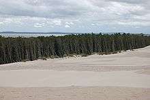
Łebsko seen from the dune
The Łeba River flows through Łebsko Lake just before it reaches the Baltic Sea at the town of Łeba. It is 16.4 km long and 7.6 km wide. Maximum depth is 6.3 m. With an area of 7,142 ha (71.42 km²), it is the largest Pomeranian lake. A 2.5 km (1.6 mi) broad spit including the 42 m (138 ft) high Łącka Góra dune separates it from the sea.
| Wikimedia Commons has media related to Łebsko Lake. |
This article is issued from Wikipedia - version of the 9/4/2015. The text is available under the Creative Commons Attribution/Share Alike but additional terms may apply for the media files.