Łapy
| Łapy | |||
|---|---|---|---|
|
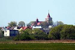
Łapy's skyline featuring St. Peter and Paul's church | |||
| |||
 Łapy | |||
| Coordinates: 52°59′N 22°53′E / 52.983°N 22.883°ECoordinates: 52°59′N 22°53′E / 52.983°N 22.883°E | |||
| Country |
| ||
| Voivodeship | Podlaskie | ||
| County | Białystok | ||
| Gmina | Łapy | ||
| Town charter | 7 January 1925 | ||
| Government | |||
| • Mayor | Wiktor Brzosko | ||
| Area | |||
| • Total | 12.14 km2 (4.69 sq mi) | ||
| Highest elevation | 130 m (430 ft) | ||
| Lowest elevation | 120 m (390 ft) | ||
| Population (2010) | |||
| • Total | 16,049 | ||
| • Density | 1,300/km2 (3,400/sq mi) | ||
| Postal code | 18-100 do 18-101 | ||
| Area code(s) | (+48) 85 | ||
| Website |
lapy | ||

Łapy [ˈwapɨ] is a town in north-eastern Poland, in Białystok County (powiat), Podlaskie Voivodeship; the administrative centre of the urban-rural gmina Łapy. It is situated in the North Podlasie Lowland, on the river Narew.
According to data from 31 December 2010,[1] the town had 16,049 inhabitants.
Situated here are the bankrupt Railway Fleet Repair Works, a dairy, and the sugar refinery closed in February 2008. Now, Łapy is a medical and educational centre for the region of the former Łapy county.
Location
The town of Łapy is located in north-eastern Poland. According to Kondracki's division of Poland into physico-geographical regions, the town of Łapy sits on North-Podlasie Plain, over the Upper Valley of Narew. The town of Łapy lies by the Narew river. The terrain is elevated here from 120 to 130 metres.
Included in Białystok agglomeration, the town is situated in the buffer zone of Narew National Park.
According to data from 1 January 2010,[2] the town area then was 12.14 km2.
Between 1954 and 1975 Łapy was the administrative centre of Łapy County of Białystok Voivodeship. Between 1975 and 1998 the voivodeship was smaller.
Residential areas
Presently Łapy comprises the following parts:
- Barwiki
- Bociany
- Goździki
- Leśniki
- Osse
- Wity
- Wygwizdowo
- Zięciuki
History
Foundation
The name 'Łapy' is of Masovian origin, and it initially represented a soubriquet of the kin, who founded the settlement on Narew. A legend links the foundation of the town with the nobleman Łappa of the Lubicz coat of arms, who settled down here during the 15th-century Masovian colonisation.
The first historical records of these lands come from the early 13th century. It is known that in 1375 Płonka Kościelna was an independent parish. Firstly Łapy was a backwater where the gentry cultivated patriotic traditions. Soon as a result of the village's development, new settlements emerged on the eastern and the western banks of the river Narew, which was a water trade route from Suraż to Gdańsk in 16th and 17th centuries, and after the WW II from Puszcza Białowieska to Tykocin; and at the east side of the high road from Suraż to Płonka.
Expansion
Following the expansion of the family, a series of backwaters were founded, including Rechy, Brusięta, Barwiki, Korczaki, Pluśniaki, Wągle, Wity, Zięciuki, Kosmyki, Łazie, Stryjce, Wojtysze. Some of those names disappeared replaced by others, such as: Goździki, Dębowizna, Bociany, Leśniki. After the Third Partition of Poland, Łapy lied in the Prussian Part, and in 1887, after the Tilsit Peace Treaty, it became a part of the Duchy of Warsaw, and later, in 1815, of The Kingdom of Poland. An important event for the future history of Łapy was Napoleonic army's marching through twice in 1812. In the 1820s the backwaters had 1000 inhabitants and 180 houses. In 1825, a fusion of six backwaters (Łapy-Barwiki, Łapy-Leśniki, Łapy-Zięciuki, Łapy-Wity, Łapy-Goździki, Łapy-Bociany) produced the farm settlement of Łapy.
Industrialisation
Łapy owe its development to the Warsaw – Saint Petersburg Mainline with a station here, opened on 15 December 1862, and to the French having built here the works for repairing steam locomotives and carriages the same year. That caused an influx of tradesmen and labourers not only from the nearby villages, but also from distant Polish locations and from The Russian Empire.
In the night of 22/23 January 1863, the railway station was captured by a group of railwaymen from the works and Władysław Cichorski Zameczek's insurgent detachment.
The repair works exist today as 'ZNTK Łapy S.A.' They played a decisive role in Łapy's urbanization, the town charter granted on 1 January 1925.
At the eve of World War II, the town population reached 8000 citizens. During the war operations, the town was 80% destroyed, and the entire local Jewish population was murdered.
Prominent people
- Józef Kosacki, the inventor of the first mine detector was born in Łapy. His device was a significant contribution to the Allies' victory in WW II.
Transport
Roads
There are two voivodeship roads crossing the town:
-
 Roszki-Wodźki – Łapy – Brańsk – Ciechanowiec
 -
 Łapy – Markowszczyzna
Furthermore, the national road ![]() runs 19 kilometres (12 miles) to the north, being upgraded to
runs 19 kilometres (12 miles) to the north, being upgraded to ![]() express-way.
express-way.
Railway
There are two railway routes going through the town:
- Warsaw – Saint Petersburg Mainline (Białystok – Warszawa)
- Łapy – Ostrołęka (partly out of order)
Łapy hosts a railway station for all kinds of trains, which is situated in the town centre; and a railway stop Łapy Osse for slow trains only, in the Osse quarter, 3 km (2 miles) from the centre.
Łapy's railway destinations are numerous: Bielsko-Biała, Warszawa, Suwałki, Białystok, Wrocław, Opole, Częstochowa, Kraków, Szczecin, Poznań.
Bus services
There are many small PKS bus stops and the main one – Łapy, next to the railway station building in the centre, from which local lines operate in the directions of Białystok, Zambrów, Siemiatycze, Bielsk Podlaski, etc.
Bike and foot trails
-
 Red bike trail; the ring route of Narew National Park
Choroszcz – Zawady – Baciuty – Dobrowoda – Turośń Dolna – Borowskie Michały – Suraż – Łapy – Płonka Kościelna – Stara Łupianka – Jeńki – Waniewo – Kurowo – Stare Jeżewo – Tykocin – Choroszcz
-
 Red foot trail of Włodzimierz Puchalski – 36 km
Łapy Osse – Gąsówka-Osse – Płonka Kościelna – Płonka-Strumianka – Stara Łupianka – Bokiny – Jeńki – Waniewo – Kurowo – Stare Jeżewo
-
 Railwaymen's green foot trail
Łapy Osse – Grochy – Turek – Pietkowo – Suraż
Economy
Until 2009, Łapy's economy was mainly based on the then functioning:
- sugar refinery, being one of the best in Poland and selling its sugar to inter alia Islamic countries and to the Middle East;
- and Railway Fleet Repair Works.
Unfortunately for the town, both of the works have been closed.
There are plans to create a subzone of Tarnobrzeg Special Economic Zone. A corresponding bill has been submitted at The Cabinet.[3]
The development of industrial economy in Łapy and its neighbourhood is hindered first of all by the close proximity of Narew National Park. On the other hand, the town has a potential for the tourism industry.
Tourism
Attractions
Historical buildings
- St. Archangel Michael's parish church complex in Płonka Kościelna:
- 1800 wooden chapel
- c. 1905 brick church
- c. 1905 fence and brick gate
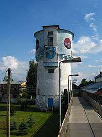
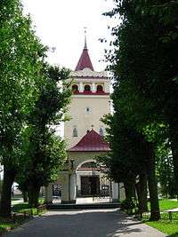
- The water tower in the complex of the railway station, built at the beginning of the 20th century
- 1920s Etkun's House in Spółdzielcza Street
- St. Peter and Paul's parish church complex:
- 1920-27 brick gate
- c. 1929 wooden presbytery
- c. 1930 brick vicarage
- 1920 chapel
- St. Adalbert's parish church complex in Uhowo
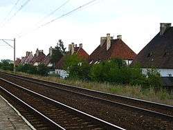
- Four wooden houses built in 1924 in the railwaymen's settlement Wygwizdowo
- 27 brick houses built in the 1930s in the railwaymen's settlement Osse
- Block group in Sikorskiego St. and Spółdzielcza St.
- Market square
Memorials
- The statue of Jan III Sobieski in the nearby village Płonka Kościelna
- A stone dedicated to LTC Stanisławo Nilski-Łapiński
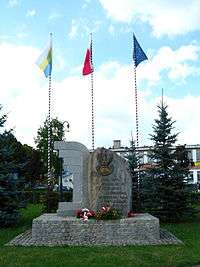
- The statue of Heroic Polish Children, dedicated to the children killed during the World War II
Graveyards
- Historical church graveyard in Płonka Kościelna
- Roman Catholic graveyard in Płonka Kościelna
- Orthodox graveyard in Osse
- Roman Catholic graveyard in Uhowo
- Jewish cemetery in Łapy
Nature
Sport clubs and organisations
- UKS 'Olimp' LO Łapy
- UKS 'Łapa' Łapy
Cultural organizations and associations
- Łapskie Towarzystwo Regionalne
Education
Kindergartens
- Council Kindergarten nr 1, ul. Polna 27
- Council Kindergarten nr 2, ul. Cmentarna 23
Primary schools
- Primary school, ul. Jana Matejki 10 (managed by 'Edukator' association from Łomża)
- Primary school nr 1, ul. Polna 9
- Primary school nr 2, ul. Piękna 17
- Primary school nr 3, ul. Letnia 1
Gymnasiums
- Gymnasium nr 1, ul. Matejki 19
- Gymnasium nr 2, ul. Letnia 1
High schools
- High School nr 1, ul. Bohaterów Westerplatte 10
- Vocational High Schools of Mechanics' Group, ul. Władysława Sikorskiego 68
- Vocational High School
- Basic Vocational School
- High School nr 2
- Specialised High School nr 2
- Postgraduate School
- High School for Adults
- High School for Adult Remedial Education
- Postgraduate School (extramural)
History literature concerning Łapy
- Bitwy i potyczki 1863-1864, oprac. Stanisław Zieliński, Raperswil 1913.
- Rocznik Statystyczny Królestwa Polskiego za 1913, Warszawa 1914.
- Skorowidz miejscowości Rzeczypospolitej Polskiej z oznaczeniem terytorialnie im właściwych władz i urzędów oraz urządzeń komunikacyjnych; Warszawa-Przemyśl 1933.
- Słownik geograficzny Królestwa Polskiego i innych krajów słowiańskich, Warszawa 1887.
- Księga adresowa Polski (wraz z W.M. Gdańskiem) dla handlu, przemysłu, rzemiosł i rolnictwa na 1930 r., Warszawa 1930.
- J. Beszta Borowski, Pół wieku zarazy 1944-200. Moje zapiski faktów i refleksji, Komorów 2002.
- S. Chankowski, Powstanie styczniowe w Augustowskiem, Warszawa 1972.
- A. Dobroński, Infrastruktura społeczna i ekonomiczna guberni łomżyńskiej i obwodu białostockiego (1866–1914), Rozprawy Uniwersytetu Warszawskiego, 197, Białystok 1979.
- Ł. Lubicz-Łapiński, Łapy i ich mieszkańcy. Zaścianki Łapińskich w XV-XVIII w., Białystok 2004.
- S. Łaniec, Partyzanci żelaznych dróg w roku 1863, Warszawa 1974.
- M. Olechnowicz, Z przeszłości Łap i okolic, z. 1, Łapy 1999.
- J. Szumski, Łapy w latach 1862-1914, Białostocczyzna”, nr 1, 1997.
- P. Sobieszczak, Poświętne wczoraj i dziś. Rys historyczny parafii i gminy do końca XX wieku., Łapy 2008.
See also
- Gmina Łapy
- Powiat łapski
- Łapy Osse
- Łapy Railway Station
References
- ↑ Ludność. Stan i struktura w przekroju terytorialnym (Stan w dniu 31 XII 2010 r.) (in Polish). Warszawa: Główny Urząd Statystyczny. 2011-06-10. ISSN 1734-6118.
- ↑ Powierzchnia i ludność w przekroju terytorialnym w 2010 r. (in Polish). Warszawa: Główny Urząd Statystyczny. 2010-08-20. ISSN 1505-5507.
- ↑ "Łapy Town and Gmina Website" (in Polish).