Čaka
| Čaka | |
| Village | |
 | |
| Country | Slovakia |
|---|---|
| Region | Nitra |
| District | Levice |
| Elevation | 188 m (617 ft) |
| Coordinates | SK 48°02′30″N 18°28′25″E / 48.04167°N 18.47361°ECoordinates: SK 48°02′30″N 18°28′25″E / 48.04167°N 18.47361°E |
| Area | 9.07 km2 (4 sq mi) |
| Population | 760 (2013-12-31) |
| Density | 84/km2 (218/sq mi) |
| First mentioned | 1287 |
| Postal code | 935 68 |
| Area code | +421-36 |
| Car plate | LV |
  Location of Čaka in Slovakia | |
  Location of Čaka in the Nitra Region | |
| Statistics: MOŠ/MIS | |
| Website: | |
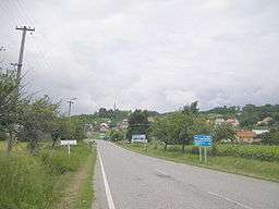
Čaka (Hungarian: Cseke) is a village and municipality in the Levice District in the Nitra Region of south-west Slovakia.
History
In historical records the village was first mentioned in 1287.
Geography
The village lies at an altitude of 188 metres and covers an area of 9.069 km². It has a population of about 830 people.
Facilities
The village has a public library a gym and a football pitch.
Genealogical resources
The records for genealogical research are available at the state archive "Statny Archiv in Nitra, Slovakia"
- Roman Catholic church records (births/marriages/deaths): 1654-1895 (parish A)
- Lutheran church records (births/marriages/deaths): 1785-1896 (parish B)
- Reformated church records (births/marriages/deaths): 1784-1903 (parish B)
See also
External links
This article is issued from Wikipedia - version of the 3/22/2016. The text is available under the Creative Commons Attribution/Share Alike but additional terms may apply for the media files.