Únehle
| Únehle | |||
|---|---|---|---|
| Municipality | |||
 | |||
| |||
 Únehle | |||
| Coordinates: 49°47′24″N 13°1′13″E / 49.79000°N 13.02028°ECoordinates: 49°47′24″N 13°1′13″E / 49.79000°N 13.02028°E | |||
| Country |
| ||
| Region | Plzeň | ||
| District | Tachov | ||
| Area | |||
| • Total | 6.06 km2 (2.34 sq mi) | ||
| Elevation | 449 m (1,473 ft) | ||
| Population (2008) | |||
| • Total | 134 | ||
| • Density | 22/km2 (57/sq mi) | ||
| Postal code | 349 01 | ||


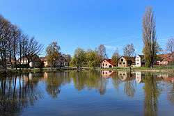
Únehle is a village and municipality (obec) in Tachov District in the Plzeň Region of the Czech Republic.
The municipality covers an area of 6.06 square kilometres (2.34 sq mi), and has a population of 134 (as at 3 July 2008).
Únehle lies approximately 30 kilometres (19 mi) east of Tachov, 26 km (16 mi) west of Plzeň, and 106 km (66 mi) west of Prague.
Gallery
 Bus stop
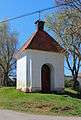 Small chapel
 Playground
References
| Wikimedia Commons has media related to Únehle. |
| Wikimedia Commons has media related to Únehle. |
This article is issued from Wikipedia - version of the 4/7/2016. The text is available under the Creative Commons Attribution/Share Alike but additional terms may apply for the media files.