Îlet à Cabrit
| Native name: <span class="nickname" ">Petite Martinique | |
|---|---|
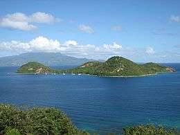 Îlet à Cabrit view from Terre-de-Haut Island. | |
 | |
| Geography | |
| Location | Caribbean sea |
| Coordinates | 15°52′30″N 61°35′40″W / 15.87500°N 61.59444°WCoordinates: 15°52′30″N 61°35′40″W / 15.87500°N 61.59444°W |
| Archipelago | Îles des Saintes |
| Total islands | 9 |
| Major islands | Terre-de-Bas Island |
| Area | 0.45 km2 (0.17 sq mi) |
| Highest elevation | 90 m (300 ft) |
| Highest point | Morne Joséphine |
| Administration | |
| Overseas department | Guadeloupe |
| Canton | les Saintes |
| commune | Terre-de-Haut |
| Mayor | Louis Molinié |
| Demographics | |
| Population | uninhabited |
Îlet à Cabrit (officially in French: Îlet à Cabrit des Saintes (literally: Goat island of les Saintes)) is an island in the Îles des Saintes archipelago, in the Lesser Antilles. It belongs to the commune (municipality) of Terre-de-Haut into the French department of Guadeloupe.
Geography
Îlet to Cabrit is located, at 1 km (0.62 mi) at the northwest of Terre-de-Haut Island, closing partially the Bay of les Saintes.
The island is approximately 1.2 km (0.75 mi) from east to west and 750 m (0.47 mi) from north to south. Its highest mount up to 90 m (300 ft), Morne Joséphine hill. it contains three headlands, Pointe à Cabrit on the West, Pointe Sable in the South and Pointe Bombarde in the East, which frame three coves: Anse sous le vent in the southwest, Anse du Bananier in the southeast and Anse du Petit Etang in the North.
By its localization, Îlet à Cabrit creates two passages into the Bay of les Saintes, la Baleine passage to the East and Pain de Sucre passage in the South, which constitute both access roads to the harbours of Mouillage and Fond-du-Curé.[1]
History
The strategic position of Petite Martinique (former name of Îlet à Cabrit) always served of sentinel's place. In 1777, France built, at the top of Morne de la Reine hill (Former name of Morne Josephine hill), a fortification named Fort de la Reine renamed later Fort Joséphine. It formed then a defensive system with the Fort Napoléon and the numerous battery of the archipelago.
The British, who occupied les Saintes in 1809, kept Fort Joséphine and added water butt to it. After the return of les Saintes under French dominion, Fort Joséphine became a penitentiary from 1851, but it was ravaged by a hurricane, on September 6, 1865. It continued however to welcome convicts on the way towards Îles du Salut, in French Guiana until 1902.
In 1871, Îlet à Cabrit became a place of quarantine: a lazaretto, was opened instead of the penitentiary.
External links
| Wikimedia Commons has media related to Ilet à Cabrit. |
Notes and references
- Péron, Patrick (2003), ASPP (Association Saintoise de Protection du Patrimoine), ed., Petite histoire de Terre de Haut: île française d'Amérique, pp. 18–24