Água Retorta
| Água Retorta | |
| Civil Parish | |
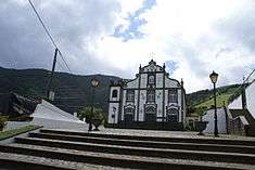
 A partial panorama of Água Retorta, looking towards the Church of Nossa Senhora da Penha da França | |
| Official name: Freguesia da Água Retorta | |
| Name origin: Portuguese for turning water | |
| Country | |
|---|---|
| Autonomous Region | |
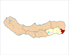
| Island | São Miguel |
| Municipality | Povoação |
| Localities | Água Retorta, Fajã do Calhau, Lomba das Fagundas |
| Center | Água Retorta |
| - elevation | 290 m (951 ft) |
| - coordinates | 37°45′44″N 25°9′29″W / 37.76222°N 25.15806°WCoordinates: 37°45′44″N 25°9′29″W / 37.76222°N 25.15806°W |
| Highest point | Tronqueira |
| - elevation | 898 m (2,946 ft) |
| - coordinates | 37°47′9″N 25°10′47″W / 37.78583°N 25.17972°W |
| Lowest point | Sea Level |
| - location | Atlantic Ocean |
| Area | 12.55 km2 (5 sq mi) |
| - urban | .20 km2 (0 sq mi) |
| Population | 489 (2011) |
| Density | 39/km2 (101/sq mi) |
| Settlement | 15th century |
| - Parish | 17th century |
| - Civil Parish | 3 July 1839 |
| LAU | Junta Freguesia |
| - location | Rua Direita |
| President Junta | Sandra Cabral Agostinho Carreiro (PS) |
| President Assembleia | Marisa Isabel Cabral Medeiros (PS) |
| Timezone | Azores (UTC-1) |
| - summer (DST) | Azores (UTC0) |
| Postal Zone | 9650-018 |
| Area Code & Prefix | (+351) 292 XXX-XXXX |
| Patron Saint | Nossa Senhora da Penha de França |
 | |
| Wikimedia Commons: Água Retorta (Povoação) | |
| Website: http://freguesiaaguaretorta.com/ | |
Água Retorta is a civil parish in the municipality of Povoação, on the island of São Miguel in the Portuguese archipelago of the Azores. The population in 2011 was 489,[1] in an area of 12.55 km².[2] Situated along the southeast coast, it is the smallest and most eastern parish in the municipality.
History
The early settlement of Água Retorta, which had its origin with the settlement of Faial da Terra, occurred with the reestablishment of colonists from old Povoação.[3] Água Retorta became important due to the abundance of farms that existed in this territory. The place name, as Gaspar Frutuoso wrote, was inspired by a ravine "that twisted and turned", that by the 16th century developed into a land of many farms.[3] His description in Saudades da Terra: From here progresses the lands of Nordeste, all in land of high cliffs, where two lengths below is the beach, called Água Retorta, because the [the water] twists and turns.[3] Paraphrasing Gaspar Frutuoso, Urbano de Mendonça Dias affirmed that the name was derived from the twists the ravine made, as it descended to rocks in the sea.[3]
Friar Agostinho Montalverne identified the parish as falling within the jurisdiction of the local authority of Faial da Terra, and clergy of the ecumenical parish of Nossa Senhora da Graça.[3] At that time, its vicar indicated the existence of 103 homes in the village, a population of 74, as well as a small hermitage dedicated to Nossa Senhora da Penha de França. This hermitage was founded by Pedro Barbosa da Silva, and constructed in 1871.[3] In addition to this chapel, there existed another temple to the invocation of Nossa Senhora das Mercês, situated in Fajã do Calhau, on land that pertained to D. Ermelinda Pacheco Gago da Câmara, but which was destroyed during a storm in 1875.[3]
Even by the 17th century, the citizenry of Água Retorta were ambitious to become an independent ecclesiastical parish, a fact that occurred by the end of that decade.[3]
There is another location, Labaçal, important in the history of Água Retorta. It is situated within the vicinity of the parish, an area of approximately 500 alqueires of thicket, 400 metres (1,300 ft) above sea level.[3]
On 3 July 1839, an official law 161 (dated 10 July 1839), decreed by Queen Maria II, elevated the Água Retorta to a civil parish, as well as the smaller hamlets Terra Chã, Lomba das Fagundas and Fajã do Calhau.[3]
Geography
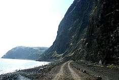
Água Retorta is located along the southeast corner of the island of São Miguel, within the municipality of Povoação, east of the municipality of Vila Franca do Campo, west of Nordeste, and south of Ribeira Grande. The community is connected by the Regional E.R.1-1ª Roadway directly to town of Nordeste and Faial da Terra, and through the mountains and valleys to the regional center of Ponta Delgada (some 75 kilometres (47 mi) away).
It consists of several smaller localities, along with the main village of Água Retorta: Terra Chã, Lomba das Fagundas and Fajã do Calhau.[3]
After a certain time, the population of the parish began to emigrate to America, in search of better conditions. From the 1960 census, there were 1253 residents in the parish.[3] Between 1960 and 1970 the population had decreased by 35%, the highest decrease in population on the island during that period.[3] By 1981, there were 617 inhabitants (of which 183 families) residing in 378 homes, within the parish.[3] By 2001, the parish counted 497 residents.[3]
Architecture
Civic
- Musical Society of Nossa Senhora da Penha da França (Portuguese: Sede da Sociedade Musical de Nossa Senhora da Penha da França), founded on 20 May 1947, by Duarte Raposo do Couto Resendes, Luís Pereira and José Raposo Carreiro, as a centre for musical study and recreation; its headquarters was constructed in 1962.
Religious
There are four teatros or impérios dedicated to the Cult of the Holy Spirit within the parish: three in Terra Chã and another in Lomba das Fagundas. The population continues to maintain the faithful tradition and devotion, with their annual feasts.
- Church of Nossa Senhora da Penha de França (Portuguese: Igreja de Nossa Senhora da Penha de França), constructed between 1871 and 1885, with the belltower an example of the original hermitage erected by Captain Pedro Barbosa da Silva, in the 17th century.[4] The church is constructed of basalt and masonry, painted in white, with sculpted stone around the doorways, windows and belfry, in the Mannerist style typical of other Micalense churches.[4]
References
- Notes
- ↑ Instituto Nacional de Estatística
- ↑ Eurostat Archived September 6, 2014, at the Wayback Machine.
- 1 2 3 4 5 6 7 8 9 10 11 12 13 14 15 Junta Freguesia, ed. (2010), Água Retorta (in Portuguese), Povoação (Azores), Portugal: Junta Freguesia de Água Retorta, retrieved 5 December 2012
- 1 2 Noé, Paula (2012), SIPA, ed., Igreja Paroquial de Água Retorta/Igreja de Nossa Senhora da Penha de França (PT072104010007) (in Portuguese), Lisbon, Portugal: SIPA – Sistema de Informação para o Património Arquitectónico, retrieved 6 May 2012
- Sources
- Lameiras, Goretti; Fontiela, J.; Borges, P.; Calado, H.; Vieira, O.; Rangel, B.; Gallagher, A. (2009). "Coastal Hazards of Fajã do Calhau (São Miguel, Azores): A First Approach" (PDF). Journal of Coastal Research. West Palm Beach, Florida: The Coastal Education and Research Foundation (56): 827–831.