Sunset Hill, Spokane, Washington
| Sunset Hill | |
|---|---|
| Neighborhood of Spokane | |
|
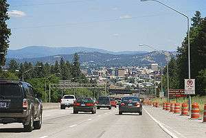
I-90 as it descends Sunset Hill into Spokane | |
| Country | United States |
| State | Washington |
| County | Spokane County |
| City | Spokane |
Sunset Hill is a neighborhood located west of downtown Spokane, Washington, and just east of the West Plains. Sunset Hill is a region with a mixture of poorly zoned areas, subdivisions, and old neighborhoods. Aside from being split in half by I-90 and the Sunset Highway, Sunset Hill sees little traffic due to the lack of thru-streets and limited exits to arterial roads.
North-side Sunset Hill homes were built in the 60's and early 70's. Upper level South-side Sunset Hill homes were built from 1970, to the mid-80's. Both have subdivisions with many Frank Lloyd Wright style homes as well as traditional homes that have been built in the adjoining areas since 2001. Many homes on both sides of Sunset Hill on the higher levels, have spectacular views of the city and are up to 500 ft higher in elevation than downtown Spokane.
Geography
Sunset Hill is located where the Columbia Plateau descends into the Spokane Valley and Latah Valley. Most of the Plateau slopes downwards towards the Columbia River to the South and West of Sunset Hill. Due to Latah Creek and the Spokane River cutting through the plateau, Sunset Hill slopes downward towards the East, losing 500 feet of elevation. Along most of the east side of the hill the drop is rather abrupt, cut thru the basalt by the rivers Spokane and Latah. Two creeks flow down the hill, allowing for a more gentle slope. Garden Springs Creek begins atop the hill and flows down through the Finch Arboretum, creek is straddled by the two main thoroughfares going up the hill, I-90 on the South and Sunset Highway on the North. Further North, Indian Canyon creek cuts a deep and compact canyon into the basalt hillside on its way past Indian Canyon Golf Course before reaching Latah Creek at its confluence with the Spokane River. North of Indian Canyon lie vast cemeteries and Palisades Park, a large nature reserve along the top of the hill. Sunset Hill is divided into two of the city's 27 official neighborhoods. North of I-90 is the West Hills Neighborhood while to the South is the Thorpe/Grandview Neighborhood. Latah Creek is the eastern boundary of the hill, though the lower part of its terraced valley is technically in the Latah Valley Neighborhood also known as Vinegar Flats.[1] U.S. Route 195 and the Burlington Northern railroad tracks serve as the official Eastern boundary of the Neighborhood south of I-90.
References
Coordinates: 47°38′57.2″N 117°26′58.8″W / 47.649222°N 117.449667°W