South Suicide Peak
| South Suicide Peak | |
|---|---|
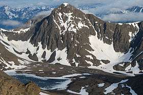 South Suicide Peak, as seen from nearby Ptarmigan Peak | |
| Highest point | |
| Elevation | 5,005 ft (1,526 m) |
| Coordinates | 61°01′47″N 149°34′29″W / 61.02972°N 149.57472°WCoordinates: 61°01′47″N 149°34′29″W / 61.02972°N 149.57472°W |
| Geography | |
 South Suicide Peak | |
| Parent range | Chugach Mountains |
| Climbing | |
| Easiest route | Most often climbed via Hauser's Gully |
South Suicide Peak is a 5,005-foot (1,526 m) mountain in the U.S. state of Alaska, located in Chugach State Park. The peak is notable for its graceful pyramidal shape and symmetry with nearby North Suicide Peak, and as the tallest mountain rising from the North side of Cook Inlet's Turnagain Arm.
Location
South Suicide Peak is located on the southern edge of Chugach State Park, in Alaska, and is positioned between North Suicide Peak, Indianhouse Mountain, Rabbit Lake, and McHugh Peak.
Outdoor Recreation and Climbing Routes
Due to its location near Anchorage, Alaska and ease of access from multiple trailheads, South Suicide is a relatively popular climbing destination. It is considered a non-technical, but rigorous, one-day climb when free of snow.
South Suicide Peak is most often climbed via the following routes.
- Via Hauser's gully on the northern face, which ascends steeply from the moraines between North and South Suicide Peaks, adjacent to Rabbit Lake
- Via the Windy Gap pass between North Suicide Peak and South Suicide Peak
- From the South side and ridge via the Falls Creek trailhead[1][2]
- Via the western ridge, accessed either from Rainbow Peak or from the upper McHugh Creek trail
References
- ↑ Shepherd, Shane; Wozniak, Owen (1975). 50 Hikes in Alaska's Chugach State Park. Seattle, WA: The Mountaineers Books. ISBN 0-89886-765-7.
- ↑ "Anchorage Press Article "Toward Higher Ground: Exploring South Suicide Peak"". Retrieved December 5, 2012.
External links
- Summit Post's page on South Suicide Peak, which includes more detailed information about routes and terrain