Sognesjøen
| Sognesjøen | |
|---|---|
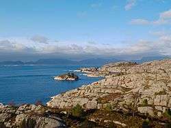 View of the strait (from Gulen) | |
 | |
| Location | Sogn og Fjordane, Norway |
| Coordinates | 61°1′N 4°51′E / 61.017°N 4.850°ECoordinates: 61°1′N 4°51′E / 61.017°N 4.850°E |
| Type | Strait |
| Primary inflows | Sognefjorden |
| Primary outflows | North Sea |
| Basin countries | Norway |
| Max. length | 35 kilometres (22 mi) |
| Max. depth | 1,300 metres (4,300 ft) |
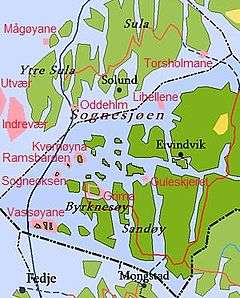
Sognesjøen is a strait in Sogn og Fjordane county, Norway. The strait is the outermost part of the large Sognefjorden. It runs along the border between Solund and Gulen municipalities. The 35-kilometre (22 mi) long strait begins around the village of Rutledal on the mainland of Gulen at the mouth of the Sognefjorden. The strait then flows in a southwesterly direction into the North Sea, just north of the island municipality of Fedje (in Hordaland county). The Sognesjøen is surrounded by many large and small islands. The islands of Sula, Steinsundøyna, Ytre Sula lie along the northern side of the strait. The mainland and the islands of Hiserøyna, Hille, Kversøyna, and Byrknesøyna lie along the southern side of the strait.[1]
References
- ↑ Store norske leksikon. "Sognesjøen" (in Norwegian). Retrieved 2013-12-16.
This article is issued from Wikipedia - version of the 3/16/2014. The text is available under the Creative Commons Attribution/Share Alike but additional terms may apply for the media files.