Mount Islip
| Mount Islip | |
|---|---|
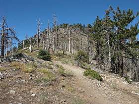 Mount Islip from the trail to the top | |
| Highest point | |
| Elevation | 8,250 ft (2,515 m) NAVD 88[1] |
| Prominence | 662 ft (202 m) |
| Listing | Hundred Peaks Section[2] |
| Coordinates | 34°20′42″N 117°50′24″W / 34.345009297°N 117.839936208°WCoordinates: 34°20′42″N 117°50′24″W / 34.345009297°N 117.839936208°W [1] |
| Geography | |
| Location | Los Angeles County, California, U.S. |
| Parent range | San Gabriel Mountains |
| Topo map | USGS Crystal Lake |
| Climbing | |
| Easiest route | Trail hike, class 1[3] |
Mount Islip (/ˈaɪslɪp/ EYE-slip) is a 8,250-foot (2,515 m) peak in the Angeles National Forest. On a clear day the sharp, high peak provides impressive views of the Mojave Desert, the Los Angeles Basin, Santa Catalina Island, and San Clemente Island.[4]
A trailhead for climbing Mount Islip is located at Islip Saddle, along the Angeles Crest Highway, approximately 53 miles (85 km) northeast of downtown Los Angeles. Another trailhead is at the Crystal Lake Recreation Area, north of Azusa.

Mount Islip from the Pacific Crest Trail
References
- 1 2 "Crystal Lake H 7A". NGS data sheet. U.S. National Geodetic Survey. Retrieved 2009-08-10.
- ↑ "Mount Islip". Hundred Peaks Section List. Angeles Chapter, Sierra Club. Retrieved 2009-08-11.
- ↑ "Mount Islip". SummitPost.org. Retrieved 2011-05-07.
- ↑ "Islip Saddle to Little Jimmy and Mount Islip". U.S. Forest Service. Archived from the original on 2009-08-14. Retrieved 2009-08-11.
External links
- "Mount Islip". Geographic Names Information System. United States Geological Survey.
- "Mount Islip, California". Peakbagger.com. Retrieved 2009-08-12.
This article is issued from Wikipedia - version of the 9/10/2016. The text is available under the Creative Commons Attribution/Share Alike but additional terms may apply for the media files.