List of bridges on the National Register of Historic Places in Utah
This is a list of bridges and tunnels on the National Register of Historic Places in the U.S. state of Utah.[1]
| Name |
Image |
Built |
Listed |
Location |
County |
Type |
|---|
| Cable Creek Bridge |
 |
1932 |
1996-02-16 |
Floor of the Valley Road, Zion National Park
37°16′13″N 112°56′19″W / 37.27028°N 112.93861°W / 37.27028; -112.93861 (Cable Creek Bridge) |
Washington |
NPS Rustic |
| Dewey Bridge |
 |
1916
destroyed 2008 |
1984-07-12 |
old SR-128 over Colorado River, Dewey
38°48′43″N 109°18′9″W / 38.81194°N 109.30250°W / 38.81194; -109.30250 (Dewey Bridge) |
Grand |
|
| Hurricane-LaVerkin Bridge |
 |
1908 |
1995-04-14 |
old SR-9 over Virgin River, between Hurricane and La Verkin
37°11′22″N 113°16′13″W / 37.18944°N 113.27028°W / 37.18944; -113.27028 (Hurricane-LaVerkin Bridge) |
Washington |
|
| Lincoln Highway Bridge |
.jpg) |
1900 |
1975-05-21 |
old Lincoln Highway over Government Creek, Dugway Proving Ground
40°10′58″N 112°55′23″W / 40.18278°N 112.92306°W / 40.18278; -112.92306 (Lincoln Highway Bridge) |
Tooele |
|
| Murphy Trail and Bridge |
|
1917 |
1988-10-07 |
Sidehill viaduct on Murphy Trail descending from the Island in the Sky district, Canyonlands National Park
38°20′30″N 109°52′30″W / 38.34167°N 109.87500°W / 38.34167; -109.87500 (Murphy Trail and Bridge) |
San Juan |
|
| Rockville Bridge |
 |
1924 |
1995-08-04 |
Bridge Road over Virgin River, Rockville
37°9′30″N 113°2′16″W / 37.15833°N 113.03778°W / 37.15833; -113.03778 (Rockville Bridge) |
Washington |
|
| San Rafael Bridge |
 |
1935, 1937 |
1996-06-03 |
Buckhorn Draw Road over San Rafael River, southeast of Castle Dale
39°4′52″N 110°39′49″W / 39.08111°N 110.66361°W / 39.08111; -110.66361 (San Rafael Bridge) |
Emery |
|
| Southern Pacific Railroad: Ogden-Lucin Cut-Off Trestle |
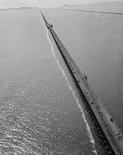 |
1902–1904 |
1972-04-14 |
Lucin Cutoff over Great Salt Lake, west of Ogden
41°12′N 112°30′W / 41.200°N 112.500°W / 41.200; -112.500 (Southern Pacific Railroad: Ogden-Lucin Cut-Off Trestle) |
Box Elder |
|
| Weber River Railroad Bridge |
 |
1897 |
2015-04-06 |
0.5 miles (0.80 km) west of Union Station along Exchange Rd.
41°13′N 111°59′W / 41.217°N 111.983°W / 41.217; -111.983 (Weber River Railroad Bridge) |
Weber |
|
| Zion-Mount Carmel Highway |
 |
1930 |
1987-07-07 |
SR-9 through Zion National Park
bridges over North Fork Virgin River, Pine Creek (twice), Co-op Creek[2]
two tunnels, including the Zion-Mount Carmel Tunnel
37°13′N 112°56′W / 37.217°N 112.933°W / 37.217; -112.933 (Zion-Mount Carmel Highway) |
Washington |
|
References