Hardbakke
| Hardbakke | |
|---|---|
| Village | |
|
View of Hardbakke (looking southwest) | |
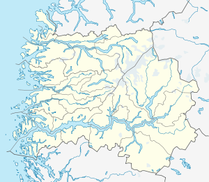 Hardbakke  Hardbakke Location in Sogn og Fjordane county | |
| Coordinates: 61°04′16″N 04°50′13″E / 61.07111°N 4.83694°ECoordinates: 61°04′16″N 04°50′13″E / 61.07111°N 4.83694°E | |
| Country | Norway |
| Region | Western Norway |
| County | Sogn og Fjordane |
| District | Sogn |
| Municipality | Solund |
| Area[1] | |
| • Total | 0.26 km2 (0.10 sq mi) |
| Elevation[2] | 3 m (10 ft) |
| Population (2013)[1] | |
| • Total | 295 |
| • Density | 1,135/km2 (2,940/sq mi) |
| Time zone | CET (UTC+01:00) |
| • Summer (DST) | CEST (UTC+02:00) |
| Post Code | 6924 Hardbakke |
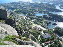
Hardbakke (English: "Hard Hill") is the administrative centre of the municipality of Solund in Sogn og Fjordane county, Norway. The village is located on the west side of the island of Sula, just across the strait from the island of Steinsundøyna. Hardbakke is located about halfway between the islet of Holmebåen and the village of Losnegard, the western- and eastern-most points in the municipality. The 0.26-square-kilometre (64-acre) village has a population (2013) of 295, giving the village a population density of 1,135 inhabitants per square kilometre (2,940/sq mi).[1] Hardbakke has an elementary school and a secondary school, as well as Solund Church.[3]
References
- 1 2 3 Statistisk sentralbyrå (1 January 2013). "Urban settlements. Population and area, by municipality.".
- ↑ "Hardbakke" (in Norwegian). yr.no. Retrieved 2010-08-12.
- ↑ Store norske leksikon. "Hardbakke" (in Norwegian). Retrieved 2010-08-12.
This article is issued from Wikipedia - version of the 8/1/2016. The text is available under the Creative Commons Attribution/Share Alike but additional terms may apply for the media files.