Geretsried
| Geretsried | ||
|---|---|---|
| ||
 Geretsried | ||
Location of Geretsried within Bad Tölz-Wolfratshausen district  | ||
| Coordinates: 47°52′N 11°28′E / 47.867°N 11.467°ECoordinates: 47°52′N 11°28′E / 47.867°N 11.467°E | ||
| Country | Germany | |
| State | Bavaria | |
| Admin. region | Upper Bavaria | |
| District | Bad Tölz-Wolfratshausen | |
| Government | ||
| • Mayor | Mr. Michael Müller | |
| Area | ||
| • Total | 24.65 km2 (9.52 sq mi) | |
| Population (2015-12-31)[1] | ||
| • Total | 24,392 | |
| • Density | 990/km2 (2,600/sq mi) | |
| Time zone | CET/CEST (UTC+1/+2) | |
| Postal codes | 82538 | |
| Dialling codes | 08171 | |
| Vehicle registration | TÖL | |
| Website | www.geretsried.de | |

Geretsried (Central Bavarian: Geretsriad) is a town in the district Bad Tölz-Wolfratshausen, located in Bavaria, Germany. The town is the most populated town in the district, with 23,219 inhabitants as of 31 December 2012.
History
Geretsried was first mentioned in the year 1083. In the early years it served a little more than a group of farms along the postal route between Munich and Innsbruck. It belonged to the city of Wolfratshausen.
In 1937 two munitions factories were built: "Dynamit Aktien Gesellschaft" and "Deutsche Sprengchemie" in the boroughs of what is today Gartenberg and Stein. Towards the end of the war, these factories employed slave and foreign labourers. Today, the remains of storage bunkers, administrative buildings, and other remains are scattered throughout the town. In May 1945 the American air force bombed the factories.
In 1946, the empty bunkers and buildings were used to house German refugees from former ethnic German areas in Eastern Europe. In 1949, the citizens began to organize themselves and on April 1, 1950 the community of Geretsried came into being. On June 27, 1970, Geretsried got city rights.
Gallery
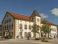 Geretsried, townhall
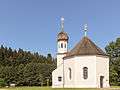 Geretsried, church: die Sankt Nikolaus Kirche
Geography
Geretsried lies on the Isar River and includes the communities of Gartenberg, Gelting, and Stein. The Bundestrasse (federal highway) 11 runs by the city. Distance to Munich is approximately 35 kilometers.
Politics
The town's new Mayor is Mr. Michael Müller. on 30 March 2014, he was elected as Mayor of Geretsried town.
Coat of arms
The cogwheel in the coat of arms symbolizes the local industry, the river symbolizes the Isar and the Conifer symbolizes the nature.
Transport
The town belongs to the Munich public transportation zone. Regional buses connect the town to Wolfratshausen and Bad Tölz. An extension of the Munich S-Bahn line S7 is planned from Wolfratshausen to Geretsried.[2]
Personalities
- Edmund Nick (1891-1974), composer, conductor and music writer
- Heinz Schneider (1921-2003), mayor from 1968 to 1986
References
External links
![]() Media related to Geretsried at Wikimedia Commons
Media related to Geretsried at Wikimedia Commons
Towns and municipalities in Bad Tölz-Wolfratshausen | ||
|---|---|---|