Gauss Peninsula
| Gauss Halvø | |
|---|---|
 Gauss Peninsula | |
| Geography | |
| Location | East Greenland |
| Coordinates | 73°30′N 23°10′W / 73.500°N 23.167°WCoordinates: 73°30′N 23°10′W / 73.500°N 23.167°W |
| Adjacent bodies of water | |
| Length | 80 km (50 mi) |
| Width | 30 km (19 mi) |
| Highest elevation | 609 m (1,998 ft) |
| Administration | |
|
Greenland (Denmark) | |
| Zone | NE Greenland National Park |
| Demographics | |
| Population | Uninhabited |
Gauss Peninsula (Danish: Gauss Halvø) is a peninsula in eastern Greenland. Administratively this peninsula is part of the Northeast Greenland National Park zone.
Geography
The Gauss Peninsula is located between the Muskox Fjord (Moskusokse Fjord) and Kaiser Franz Joseph Fjord with the Nordfjord at its western end and the Foster Bay of the Greenland Sea shore on its southeastern side.[1]
The peninsula is mountainous, with the Hjelm Range (Hjelmbjergene) located on the southern coast and the Giesecke Range (Giesecke Bjerge) located in the eastern part of the peninsula. Hold with Hope peninsula is located further to the east, beyond the Badland Valley (Badlanddal).[2]
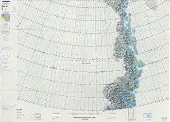 Map of Northeastern Greenland. |
History
The second German North Polar Expedition 1869–70 originally gave the name Cap Gauss to a point on the south side of this peninsula, but A.G. Nathorst’s 1899 expedition was unable to determine the position because of the rounding of the coast and applied the name Gauss Halfö to the peninsula as a whole. It is named after German mathematician Carl Friedrich Gauss.
References
- ↑ "Gauss Halvø". Mapcarta. Retrieved 20 April 2016.
- ↑ "Catalogue of place names in northern East Greenland" (PDF). Geological Survey of Denmark. Retrieved 18 June 2016.