Foum Gleita Dam
| Foum Gleita Dam | |
|---|---|
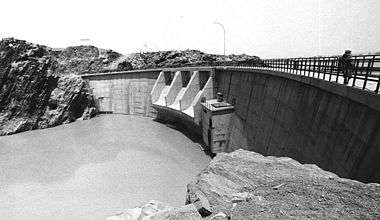 Downstream face of the arch dam | |
 Location of Foum Gleita Dam in Mauritania | |
| Country | Mauritania |
| Location | Foum Gleita |
| Coordinates | 16°09′27.18″N 12°39′55.41″W / 16.1575500°N 12.6653917°WCoordinates: 16°09′27.18″N 12°39′55.41″W / 16.1575500°N 12.6653917°W |
| Purpose | Irrigation |
| Status | Operational |
| Opening date | 1988 |
| Dam and spillways | |
| Type of dam | Arch |
| Impounds | Gorgol River |
| Height | 38 m (125 ft) |
| Reservoir | |
| Total capacity | 500,000,000 m3 (410,000 acre·ft) |
The Foum Gleita Dam is an arch dam on the Gorgol River near Foum Gleita in the Gorgol Region of Mauritania. The dam was completed in 1988 with the primary purpose of supplying water for the irrigation of up to 4,000 ha (9,900 acres) of crops.[1][2]
References
- ↑ "Dams in Africa". UN FAO. Retrieved 25 March 2014.
- ↑ "Deplacements De Popuution Autour D'un Barrage En Zone Saheuenne Le Cas De Foum Gleita" (PDF) (in French). ORSTOM. 1989. Retrieved 25 March 2014.
This article is issued from Wikipedia - version of the 8/3/2016. The text is available under the Creative Commons Attribution/Share Alike but additional terms may apply for the media files.