Cumberland Falls State Resort Park
| Cumberland Falls State Resort Park | |
|---|---|
|
Cumberland Falls | |
 Location in Kentucky | |
| Type | Kentucky state park |
| Location | McCreary County & Whitley County, Kentucky, United States |
| Nearest city | Corbin, Kentucky |
| Coordinates | 36°50′27″N 84°19′58″W / 36.84083°N 84.33278°WCoordinates: 36°50′27″N 84°19′58″W / 36.84083°N 84.33278°W |
| Area | 1,657 acres (671 ha) |
| Elevation | 1,073 feet (327 m) [1] |
| Established | August 21, 1931[2] |
| Operated by | Kentucky Department of Parks |
| Visitors | 750,000+ (in 2009) |
| Status | Open year-round |
| Official website | |
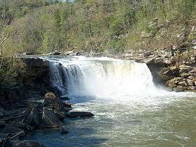

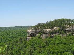
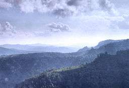
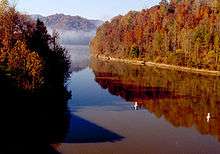
Cumberland Falls State Resort Park is a park located just southwest of Corbin, Kentucky and is contained entirely within the Daniel Boone National Forest.[3] The park encompasses 1,657 acres (671 ha) and is named for its major feature, 68-foot-tall (21 m) Cumberland Falls. The falls are one of the few places in the western hemisphere where a moonbow can frequently be seen on nights with a full moon.[2] The park is also the home of 44-foot (13 m) Eagle Falls.
History
After the discussion of building an hydroelectric power plant above the falls in 1927, Kentucky native T. Coleman du Pont offered to buy the falls and surrounding acreage in order to create a state park. Although he died before he could purchase the land, his wife purchased the falls and the 593 acres (240 ha) surrounding it for $400,000 on March 10, 1930, after the Kentucky General Assembly (legislature) approved the creation of the state park. Cumberland Falls was dedicated as a state park at 1:30 p.m. on August 21, 1931.[2]
Following a $2 million renovation project in 2006, the park received an upgraded rating from two diamonds to three diamonds from the American Automobile Association (AAA) in 2007. Kentucky Dam Village State Resort Park also received the upgraded rating. The two facilities were the first state resort parks to achieve the three-diamond rating following AAA's revision of its rating system in 2001.[4]
Amenities and recreation
- Dupont Lodge - 51 guest rooms
- Multiple modern one and two-bedroom
- Campground with 50 campsites with utilities
- Riverview Restaurant
- Visitor's center
- Interpretive center
- Mountain biking
- Hiking - approximately 20 miles of trails
- Fishing in Cumberland River
- Horseback rides
- White water rafting and canoeing on Cumberland River[5]
Events
- Backpacking 101 - (Several times a year)
- Native American Weekend - (March)
- Overnight Canoe Adventures - (April, May, October)
- Nature Photography Weekend - (April)
- Birding and Wildflower Weekend - (May)
- Kentucky Hills Craft Festival - (September)
- Moonbow Trail Trek - (November)
References
- ↑ "Cumberland Falls State Park". Geographic Names Information System. United States Geological Survey.
- 1 2 3 "History". Cumberland Falls State Resort Park. Kentucky Department of Parks. Archived from the original on 2015-06-04. Retrieved September 28, 2013.
- ↑ Kleber, John E., ed. (1992). "Parks, State". The Kentucky Encyclopedia. Associate editors: Thomas D. Clark, Lowell H. Harrison, and James C. Klotter. Lexington, Kentucky: The University Press of Kentucky. ISBN 0-8131-1772-0.
- ↑ "Diamonds in the Rough". The Times-Tribune. Corbin, Ky. 2007-03-27. Retrieved 2007-03-29.
- ↑ "Things to do". Cumberland Falls State Resort Park. Kentucky Department of Parks. Retrieved September 28, 2013.
External links
 Cumberland Falls State Resort Park travel guide from Wikivoyage
- Cumberland Falls State Resort Park Kentucky Department of Parks
- Cumberland Falls State Resort Park at American Byways