Brantingham
| Brantingham | |
 Brantingham |
|
| Population | 370 (2011 census)[1] |
|---|---|
| OS grid reference | SE940295 |
| – London | 155 mi (249 km) S |
| Civil parish | Brantingham |
| Unitary authority | East Riding of Yorkshire |
| Ceremonial county | East Riding of Yorkshire |
| Region | Yorkshire and the Humber |
| Country | England |
| Sovereign state | United Kingdom |
| Post town | BROUGH |
| Postcode district | HU15 |
| Dialling code | 01482 |
| Police | Humberside |
| Fire | Humberside |
| Ambulance | Yorkshire |
| EU Parliament | Yorkshire and the Humber |
| UK Parliament | Haltemprice and Howden |
Coordinates: 53°45′13″N 0°34′32″W / 53.753653°N 0.575488°W
Brantingham is a village and civil parish in the East Riding of Yorkshire, England. It is situated about 2 miles (3 km) north of Brough, and 12 miles (19 km) west of Kingston upon Hull. It lies to the north of the A63 road. According to the 2011 UK Census, Brantingham parish had a population of 370,[1] a decrease on the 2001 UK census figure of 410.[2]
The noble family of Brantingham (or de Brantingham), which included Ralph de Brantingham, King's Chamberlain to King Edward III, and Thomas de Brantingham, Lord Treasurer under the same king and later Bishop of Exeter, originally came from the village. In 1333, Lewis de Beaumont, a French-born Bishop of Durham described by a chronicler as "semi-literate, avaricious, and fitfully prodigal", died in the village. He had played some part in defending North-East England from Scottish incursions.[3]
The church dedicated to All Saints was designated a Grade II* listed building in 1966 and is now recorded in the National Heritage List for England, maintained by Historic England.[4]
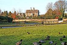
The village has one pub, the Triton, and a duckpond.
The Triton Inn was formerly a coaching inn on the road west from Hull to Brantingham, then being an important staging post on the road between Welton and South Cave. At that time the present inn was called The Tiger and had a wheelwrights and an agricultural engineer (a Mr Watson) in the yard at the front. The pub changed its name to the Wounded Tiger in the 1850s, but took its present name in the 1860s after the triton in the family crest of the Sykes family, who bought nearby Brantingham Thorpe. They owned the pub and another Triton Inn on their Sledmere estate just north of Driffield, also in the East Riding of Yorkshire.
The site of Brantingham Roman villa is found at the other end of the long lane leading south-east from the village, known as Brantingham Outgang. This villa would have been closely associated with the Roman town at Petuaria Civitas Parisiorum (Brough-on-Humber) until it burnt down some time in the mid-4th century. In what is nowadays a flat, gated area located next to a large wood overlooking the main road running between South Cave and Elloughton, traces of the villa (in the form of mosaic floors and hypocaust heated rooms) were first discovered in late September 1941 (in what had been a working quarry since the Middle Ages and into the 1980s). As a result of the quarrying there is now no trace today, but an aerial survey made during the war confirmed the presence of Roman buildings associated with the villa on the other side of the modern road. This Roman site attracted later notoriety in 1948, when a team of archaeologists from the Hull & East Riding museum prepared the first of a group of mosaic pavements found at the villa site during the war, for removal. Overnight it was stolen and although the rest were safely recovered to the museum and are on display to this day, the missing first one has never been found. Neither has it ever been established exactly how it was stolen. This art theft was later taken by the historical novelist Clive Ashman as the basis for his novel MOSAIC – the Pavement that Walked (Voreda Books) which provides a fictionalised account of both the 1941 discoveries, police investigations into the 1948 theft, and the original fate of the Roman villa. Today, only a full-colour reconstruction scale drawing taken by the mosaic expert David Neal from black-and-white photographs of the time survives to show what the stolen mosaic would have originally looked like.
In the 1950s the village gave its name to HMS Brantingham, a Ham class minesweeper.
Brantingham is on the major 155 bus route between Hull and South Cave, Goole and Howden, and is the last village west within the Hull telephone area.
The village has significant historic houses, including Brantingham Hall and Brantingham House which overlook the duck pond in the centre of the village.
Brantingham is situated on the western flank of the southern end of the Yorkshire Wolds, its surrounding area having a different character to the east from that to the west. The west, towards the Vale of York, is flat. To the east are hills of the Yorkshire Wolds. A local landmark is Spout Hill, named after an old water spout located at the bottom. The road from this spout leads steeply upwards to a height of approximately 330 feet (101 m), with a westerly aspect towards the Vale of York. The road then degrades to a bridleway leading to Riplingham, Elloughton and Welton. Two-thirds of the way up Spout Hill is another path that leads south, through the woods to Elloughton.
The Yorkshire Wolds Way National Trail, a long distance footpath passes through the village.
References
- 1 2 "Key Figures for 2011 Census: Key Statistics: Area: Brantingham CP (Parish)". Neighbourhood Statistics. Office for National Statistics. Retrieved 3 February 2013.
- ↑ "2001 Census: Key Statistics: Parish Headcounts: Area: Brantingham CP (Parish)". Neighbourhood Statistics. Office for National Statistics. Retrieved 14 May 2008.
- ↑ Fraser, C. M. (2004). "Beaumont, Louis de (d. 1333)". Oxford Dictionary of National Biography. Oxford, UK: Oxford University Press. Retrieved 24 February 2016.
- ↑ Historic England. "Church of All Saints (1103351)". National Heritage List for England. Retrieved 18 August 2013.
Further reading
- Brantingham Roman Villa: discoveries in 1962 - J. Liversedge; D.J. Smith and I.M. Stead. “Britannia - A Journal of Romano-British and kindred studies” Volume 4, 1973.
- Roman Mosaics in Britain: An Introduction to their schemes and a catalogue of paintings - D.S. Neal 1981.
- Brading, Brantingham and York: a new look at some fourth-century mosaics - R. Ling “Britannia - A Journal of Romano-British and kindred studies” Volume 22, 1991.
- Roman Humberside (2nd edn.) Humberside County Council Archaeology Unit: B. Sitch and A. Williams 1992.
- Roman Mosaics of Britain: Volume I: Northern Britain incorporating the Midlands & East Anglia: - D.S. Neal & S.R. Cosh ‘Society of Antiquaries of London’ 2002 Illuminata Publishers.
- The Roman Mosaics at Hull D.S. Smith (3rd edition) 2005, M. Foreman and D. Crowther Hull & East Riding Museums & Art Gallery.
- Mosaic (Voreda Books) Clive Ashman ISBN 978-0-9556398-0-7
- Gazetteer — A–Z of Towns Villages and Hamlets. East Riding of Yorkshire Council. 2006. p. 4.
External links
 Media related to Brantingham at Wikimedia Commons
- Brantingham in the Domesday Book
- "A Brantingham and Elloughton Walk",