Anton Dohrn Seamount
| Anton Dohrn Seamount | |
|---|---|
 | |
| Summit depth | 600 metres |
| Height | 1,500 m |
| Location | |
| Location | North Atlantic Ocean |
| Coordinates | 57°30′N 11°00′W / 57.500°N 11.000°WCoordinates: 57°30′N 11°00′W / 57.500°N 11.000°W |
| Country | United Kingdom (EEZ) |
| Geology | |
| Type | Guyot |
| Last eruption | ~40 million years |
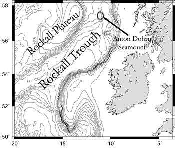
The Anton Dohrn Seamount is a guyot in the Rockall Trough in the northeast Atlantic. It was named after the German fishery research vessel which discovered it at the end of the 1950s which, in turn, had been named after the 19th-century biologist Anton Dohrn.
The feature rises from approximately 2,100 metres to 600 metres below sea level and has a sedimentary layer approximately 100 metres thick. It arose through episodic volcanic activity between 70 and 40 million years ago.[1]
Around the base of the seamount is a slight "moat" where the sea-bottom is at a lower depth than the surrounding terrain.
Releasing their findings in August 2016, the Deep Links project team, a collaboration between Plymouth University, the University of Oxford, the Joint Nature Conservation Committee and the British Geological Survey, spent six weeks at sea onboard the RSS James Cook deploying robot submersibles to film, photograph and collect samples from an exceptionally diverse coral reef environment now revealed on the top of the plateau-like seamount.
References
- ↑ O'Connor, Stofferes, Wijbrans, Shannon and Morrissey (2000). Evidence from episodic seamount volcanism for pulsing of the Iceland plume in the past 70 Myr Archived April 11, 2007, at the Wayback Machine., Nature 408, 954-958.
External links
- WWF report on seamounts of the Northeast Atlantic (PDF)
- BBC webpage report on the 2016 report on coral reef habitat